Slovenščina:
Slap Čedca na koncu Makekove Kočne pri Zgornjem Jezerskem pada čez navpično amfiteatralno steno iz neplastnega triasnega dolomita. Zaradi pretrtosti kamnine se je ta drobila, ostrorobi delci in dolomitna moka pa so se kasneje sprijeli v trdno brečo. Značilno rjavo-rdečo barvo, zaradi katere se odlom vidi že od daleč, ji dajejo železove spojine. Iz neplastnega dolomita so tudi pobočja levo in desno od Čedce. Ob desni strani odlomne stene je sivo zeleni pas, ki je nastal zaradi vložkov sivkastega peščenjaka. Gore nad stopnjo, čez katero pada tudi slap, pa so iz skladnatega ali plastovitega zgodnjetriasnega dachsteinskega apnenca.
Gore nad in ob slapu - The mountains above and beside the waterfall area
Čedca je nastala tako, da se je ob navpičnem prelomu odlomil več kakor sto metrov visok del gore, nastala je stena, za njo pa slap. Prepredenost Grintavcev s prelomi, lega skladov na tem delu in umik ledenika so omogočili nastanek slapu v bližnji geološki preteklosti.
Slap napaja snežnica iz krnice med Kočno in Velikim kupom. Ustje je široko in koritasto, kar priča o nekdanjem močnejšem ledeniškem odtoku. Slap je enopramenski, v zgornjem delu prostopadajoč in ne prav vodnat. To omogoča, da lahko pozimi zamrzne, v sušnem obdobju pa lahko presahne. Njegova posebnost je bila do nedavnega njegova višina. Slap je namreč prvih 70 metrov prosto padal, nadaljnjih 60 pa je drsel ob steni. S tem je bila Čedca s 130 metri najvišji slovenski slap.
Mesto podora nekoč (levo) in danes (desno) - The area of the rockfall in the past (left) and present (right)
Kakor hitro je slap Čedca nastal, prav tako naglo je potekala njegova preobrazba. Zgodba iz preteklosti se je tako konec maja 2008 ponovila. Voda je med številnimi nalivi in zimskimi zmrzalmi počasi zrahljala kameninske sklade stopnje, čez katero je slap padal. Posledica je bila vrsta podorov, ob katerih se je ves zgornji del stopnje podrl in zgrmel na melišče pod slapom. Slap je ostal, voda še vedno teče čez kamnito stopnjo. Vendar pa se je njegova višina močno znižala. Glede na velikost podora je šlo za manjši podor, sprožilo se je nekaj tisoč kubičnih metrov kamenine.
Podori so pobočni procesi, plazovi, kjer gre za gibanje prsti, skal in organskega materiala proti nižjim predelom. Pri skalnih podorih gre za odlom dela trdne kamnine od strmega pobočja, gmota pa se premika večinoma v obliki prostega pada, prihaja pa tudi do odbijanja od tal in kotaljenja. Gradivo se torej premešča zaradi gravitacije in delovanja vode. Največkrat gre za geomorfološke procese, kot je rečno spodjedanje pobočja, denudacijo, odnašanje prepereline in razkrivanje kamnine, zlasti ob ciklu zamrzovanja in odtajevanja. V tekočem stanju, med poznojesenskimi deževji, voda vstopi v mnoge luknjice, zareze in razpoke znotraj kamnine. Ko temperatura pade pod 0°C voda zmrzne, njena prostornina se poveča za okoli 10 odstotkov. Posledica tega procesa je, da se razpoke v kamnini razširijo. Ko se led stali, lahko voda prodira globlje v te razširjene razpoke, kjer kasneje zopet zmrzne. Celo najmočnejše skale niso kos tej sili, širjenje razpok pa poteka počasi, a vztrajno. Tudi človekove aktivnosti, kot so rudarjenje, gradnja in izkopavanje, lahko povzročijo podor. Velikokrat so sprožilec tudi potresi.
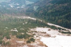
Pogled proti dolini nekoč in danes - The view of the valley in the past and present
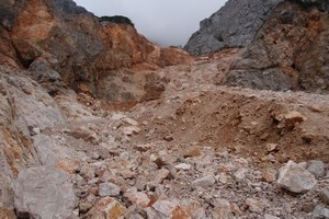
Stena, preko katere v globino pada Čedca, je prepredena s številnimi prelomi, ki potekajo v različnih smereh. Večina prelomov je med seboj vzporedna v smeri doline, prelomne ploskve pa visijo proti jugozahodu. Enako dobro kot vertikalni so vidni tudi prečni prelomi. Ob dveh je nastala tudi osrednja zajeda v slapu. V preteklosti sta bili zajedi dve, ki pa sta se sčasoma povezali v eno večjo. Ta večja zajeda je rasla in je bila tudi vzrok za oslabitev stabilnosti sklada kamnine nad njo. Leta 2008 se je ta kamnina odtrgala in zgrmela v dolino.
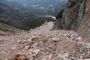
S podorom je pod slapom nastal ogromen meliščni vršaj, ki je zasul majhen tolmun slapa z ogromno količino kamenja in skal. Tudi znameniti slikoviti gozdiček macesnov nad slapom je zdaj manjši za četrtino, saj ga je toliko zgrmelo v dolino med podorom. Podor je ustvaril pravi blatni drobirski tok. Skale, mehka tektonska breča, peščenjak, melj, voda in sneg so se pomešali med seboj in začeli potovati po hudourniški strugi. Blatni tok pa ni imel veliko zagona. Največje odtrgane skale so se zakotalile proti dolini vse do sotočja levega pritoka Čedce pod slapom, drobirski tok pa je »manjše« skale, ki jih je nosil, odlagal ob strani.
Številni prelomi v steni podora - Numerous faults in the cliff face where the rockfall took place
Opis poti: Mesto podora se lepo vidi že malo pod predlaganim parkiriščem. Od njega nadaljujte naravnost po makadamski cesti v smeri Malega vrha. Pridete do odcepa poti na levi strani, tu vam tudi tablica pove, kam bo treba zaviti. Ko pred seboj zagledate široko reko drobirja, lahko odgovorite še na zadnje vprašanje in se vrnete na izhodišče. Ni vam treba hoditi dalje v smeri slapu. Če se za slednje vseeno odločite, zavijete desno in se po gozdu vzpnete do kolovoza, kateremu sledite do odcepa dobro vidne stezice na levi strani. Tu lahko stopite še nekaj metrov do gozdne meje in najdete mesto, kjer se najlepše vidi podor in slap skozi drevje in ruševje. Hoja od te točke naprej je lahko nevarna. Steza sicer teče med ruševjem, proč od drobirskega toka, vendar bi lahko ob morebitnem novem podoru kamenje letelo tudi na ta del poti. To kažejo posamezni kosi kamenine na tleh. Če bi se vseeno odločili (na lastno odgovornost seveda), da se podoru približate, pa niti ne razmišljajte, da bi šli dlje od mesta, kjer je steze konec. Hoja naprej ne le, da ni dovoljena, temveč je tudi smrtno nevarna. Ne gre zgolj za nevarnost novega podora (da se bo to zagotovo zgodilo kažejo primeri iz preteklosti, pa tudi ogromni kamniti bloki desno od slapu), temveč tudi nevarnost zaradi stalno padajočega kamenja, nestabilnosti kamenine in njenega premikanja na samem področju melišča.
Prosim, da na svoji poti ne puščate odpadkov in vse pustite tako, kot je bilo ob vašem prihodu.
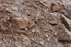
Prelomi od blizu - Faults in close-up
Vprašanja:
1. Opazujte okolico ob vzponu po makadamski cesti (med točkama A1 in A2). Če opazite primere erozije, jih opišite. Ali je ob cesti mogoče opaziti ostanke podorov oziroma odlomov kamenine iz preteklosti?
2. Od točke A2 se napotite v smeri, ki jo označuje tablica. Ko boste prehodili nekaj deset metrov se ustavite. Pred seboj boste videli posredne posledice podora. Opišite jih in skušajte določiti, zakaj je do njih prišlo.
3. Malo pod točko A1 ali na točki A5 ocenite, za koliko se je višina slapu po podoru znižala (upoštevajte zgolj del, kjer voda prosto pada). Čeprav ne bi smelo biti težav, bo uporaba daljnogleda za lažje opazovanje slapu in podora iz daljave vsekakor koristna.
4. Če se boste slikali s pogledom na mesto podora in slap Čedco, lahko sliko neobvezno pripnete v log.
Odgovore pošljite preko geocaching profila. Potem lahko logirate svojo najdbo. Če se je pri odgovorih kje zataknilo, vas bom obvestil.
Slap Čedca - The Čedca Waterfall
English:
The Čedca waterfall, located in the valley head of Makekova Kočna at Zgornje Jezersko, falls over a vertical amphitheatre-like face consisting of non-stratified Triassic dolomite. Grinding caused the rock to break down, while sharp-edge fragments and fine-grained dolomite flour were later cemented together into hard breccia. The typical brown-reddish colour, seen at the break from afar, is given to the rock by iron compounds. The same triassic dolomite forms the slopes to the left and to the right of the Čedca waterfall. To the right of the broken face there is a greyish green strip of grey sandstone. The mountains above the waterfall area are from stratified or layered early-Triassic Dachstein limestone.
The water fills the cracks and the ice widens them
The Čedca waterfall was formed after a more than 100-metre part of the mountain broke off vertically. Frequent faults in the Grintavci mountain region, the location of layers in this area and the glacier retreat made it possible for the waterfall to be formed in recent geological past.
The waterfall is filled with meltwater from the cirque between Kočna and Veliki kup mountains. Its outlet is wide and resembling a river bed, which is proof of a previous larger glacier water flow. The waterfall is single, with a free fall in its upper area, and not very watery. This makes it possible to freeze in winter, while in a dry season it can dry up. Its distinctive feature until very recently was its height. In the upper 70 metres it was falling freely, while in the lower 60 metres it was falling along the rock face. The Čedca waterfall was, with its 130 metres, the highest Slovenian waterfall.
Led skalo zdrobi - The ice breaks the rock
Equally rapidly as the Čedca waterfall was formed, it was also transformed. Thus, the story from its past repeated in the end of May 2008. During several downpours and winter frosts, the water passing through the rock over which the waterfall was falling caused the material to become unstable. As a consequence, there was a series of rockfalls during which the entire upper part of the cliff broke off and fell onto the scree under the waterfall. The waterfall remained there and its waters still flow over the rock cliff, but its height changed considerably. The rockfall was considered to be a minor one with several thousand cubic metres of rock detaching and falling off the cliff.
Rockfalls are processes that develop on sloped surfaces, involving downward mass movement of soil, rocks and organic material. In a rockfall, a part of the rock breaks off a cliff face and moves mostly by falling freely, bouncing and tumbling. The material therefore moves because of gravity and water activity. These processes are mostly geomorphological, for example slope erosion by a river flow, denudation, eluvial deposits removal and rock exposure, especially during freeze-thaw cycles. During late-autumn rain periods, flowing water enters little holes, joints and cracks inside the rock. When the temperature falls below zero degrees Celsius the water freezes and its volume increases by about ten percent. The consequence of this process is that the walls of the joints are strained and widened. When the ice melts the water passes deeper and later freezes again. Not even the hardest rocks can resist this force; the cracks are widened slowly but persistently. Human activity like mining, construction works and digging can also cause rockfalls. Earthquakes can be another trigger of rockfalls.
Drobirski tok - Muddy debris flow
The rock face over which the Čedca waterfall flows is full of faults that run in several directions. The majority of faults are parallel to the valley while the fault planes hang towards south-west. Both vertical and horizontal faults are visible. Along two of them the central indentation in the waterfall was formed. In the past there were two indentations, but gradually they were connected into a single large one. This indentation grew and was also the reason for the weakened stability of the rock above. In 2008 this rock detached and hurtled down into the valley.
On the scree under the waterfall, the rockfall created an enormous fan which filled the small pool of the waterfall with stones and rocks. Above the waterfall there is also a renowned larch wood, which is now smaller by a quarter due to the rockfall. The rockfall created a muddy debris flow. Rocks, soft tectonic breccia, sandstone, silt, water and snow were mixed into the flow and started to move along the stream bed. However, the flow did not have much force. The largest detached rocks reached as far as the left tributary stream of Čedca, while the debris flow deposited smaller rocks to its sides.
Izhodišče in mesto, kjer se začne steza - The starting point and the area where the path starts
Access description: The area of the rockfall is visible already before the suggested parking place. Continue walking on the dirt road in the direction of the Mali vrh mountain. When you reach the fork on the left side of the road there is a signpost telling you where to turn. When you see a wide river of debris you can answer the last question and return to the starting point. You don't need to walk further towards the waterfall. Nonetheless, if you decide to do so, turn right and go up the wood till the dirt road and follow the road until you find a well-trodden path on the left side. Here you can go further until the tree line from where you have the best view of the rockfall and the waterfall through the trees and mugho pines. Walking beyond this point can be dangerous. The path goes through the pines, away from the debris flow, but a new rockfall could cause rocks to fall on this part of the path – you can see individual rocks on the floor. If you decide to approach further (at your own risk!), you should NOT walk beyond the spot where the path ends. Walking there is not allowed and, what is more, it is extremely dangerous. Not only is there a possibility of a new rockfall (it is certain to happen, judging from past events as well as from huge rock blocks to the right of the waterfall), but there is a constant danger because of falling stones, unstable rock and its movement on the scree slope.
Please do not dispose of garbage. Leave everything as it was at your arrival.
Opozorilo, da dostop do slapu ni dovoljen, in bloki, ki desno od slapu čakajo, da zgrmijo v dolino –
The no-access warning sign; rock blocks to the right of the waterfall, on the verge of hurtling into the valley
Questions:
1) Observe the surroundings while going up the dirt road (between points A1 and A2). If you see erosion areas, describe them. Is it possible to see leftovers of previous rockfalls?
2) From point A2 follow the direction of the signpost. Stop after having walked several ten metres. In front you will see indirect consequences of the rockfall. Describe them and try to determine their cause.
3) A bit below the point A1 or at the point A5, try to estimate for how much the height of the waterfall was lowered after the rockfall (just the upper part where the water falls freely). Though you should have no problem doing this, binoculars will help you watch the area of the waterfall and the rockfall from a distance.
4) If you take a photo with the view of the rockfall and the Čedca waterfall, you can optionally paste it to your log.
Please send your answers via geocaching profile. After that you can log your find. If there is a problem with the answers, I will contact you.