Kåsjön - en sprickdalssjö formad av jordens krafter
English description below...
Om sprickdalssjöar och hur Kåsjön skapades:
Kåsjön är en sprickdalssjö, en av de större i Sverige. Dess storlek som sprickdalssjö och dess höjd, 109,2 meter över nuvarande havsnivå, gör Kåsjön unik i regionen. I slutet av den senaste istiden (Weichsel-istiden) nådde havet som högst 120 meter över nuvarande havsnivå, vilket betyder att havet bara fyllde sprickdalen under en kort tid. Sjön förblev näringsfattig.
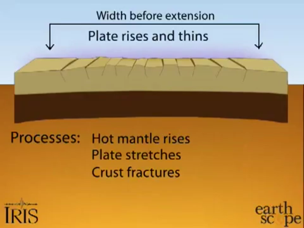
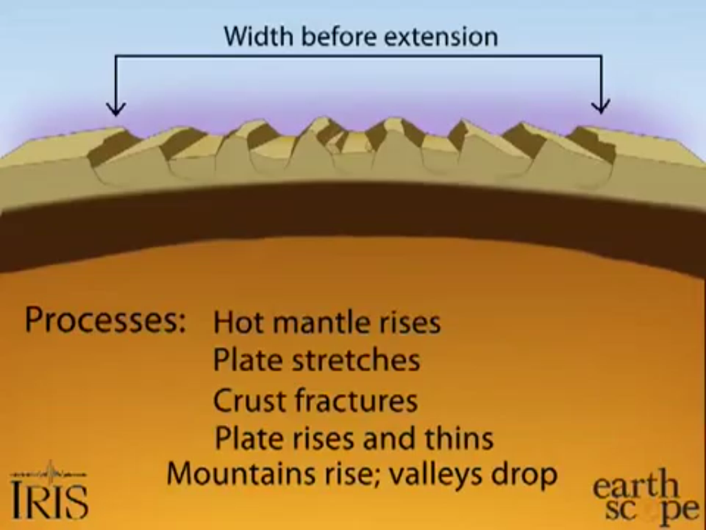
Hur uppkom en sprickdalssjö? Den skapades av kraftiga rörelser i jordskorpan för 40-50 millioner år sedan. Dessa rörelser orsakades av att den varma manteln rörde sig uppåt och sträckte ut jordskorpan. Den gav samtidigt jordskorpan sprickor. Detta gjorde jordskorpan veckad. Desto mer jordskorpan trycktes upp av den varma manteln, desto mer sträcktes den ut, desto större sprickdalar bildades. I Kåsjöområdet och landskapet runt omkring ser man inte bara bevis på detta i sjön, utan i hela landskapet, som är veckat. Vecken brukar gå i en mer eller mindre tydlig riktning. Partille är inget undantag. Dessa sprickdalar vidgades och fördjupades sedan av erosion och vittring. Sprickdalssjöar blidas när dessa sprickdalar fylls med vatten.
Landskapet kring Kåsjön har även formats av den senaste istiden, som
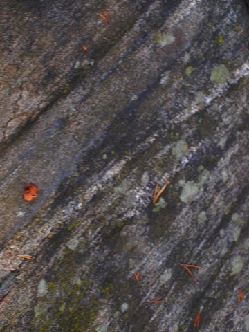
hade sin början för ca 110 000 år sedan. Denna istid pågick under ca 100 000 år och slutade alltså för ca 10 000 år sedan. Isens framfart syns tydligt på berghällarna kring Kåsjön, man kan bl.a. se isräfflor och rundhällar. Dessa bildades under isens framfart över berghällarna. Vid denna EarthCachens koordinater finns en häll med tydliga isräfflor. Dessa skapades då isen skrapade loss sten och sand, som den sedan drog med sig. Isens rörelse lämnade sedan sina spår på berghällarna, dessa syns än idag. Rundhällar skapades när isen gled över berghällar med finare sedimentkorn, som polerade hällarna runda.
Sprickdalssjöar är ofta näringsfattiga, oligotrofa. Kåsjön är inget undantag, något man kan se på vattnets klarhet. De västra delarna är dock rikare på näring än de östra tack vare tillflöden av näring från närliggande bergs- och mossmarker.
Om sjön:
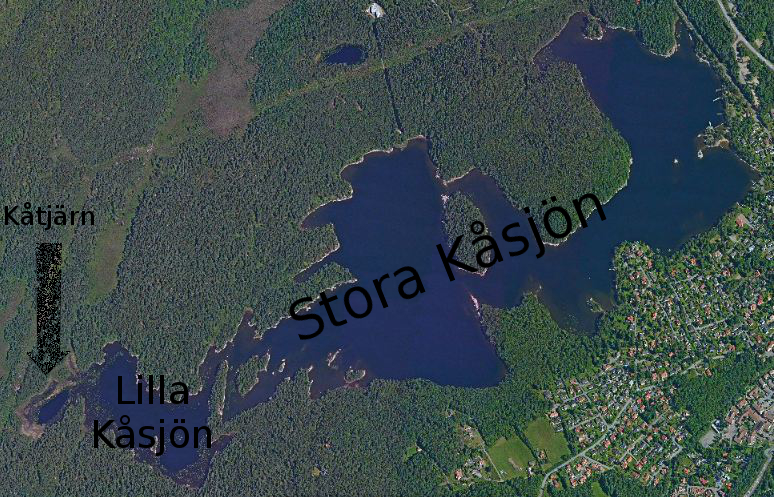
Kåsjön är en sprickdalssjö belägen i södra Partille, med utlopp i Säveån och Göta Älv. Ytan är 1,03 km², med ett maxdjup på 32 meter och en volym på ca 7,7 milliarder liter vatten, eller 7 700 000 kubikmeter. Sjön är delad i tre delar, Lilla och Stora Kåsjön som avgränsas med en grund tröskel vid Spängerna i väst. Kåtjärn är den tredje delen av sjön och ligger längst åt väst. Kåsjön är mest känd som en bra badsjö, med goda fiskemöjligheter (med fiskekort). I sjön finns bland annat gädda, mört, abborre och ål. Partilles dricksvatten tas ifrån Kåsjön, som är en ren sjö tack vare sitt höga läge. Med en vattenyta på 109,2 meter över nuvarande havsnivå når inte så mycket föroreningar upp till sjön.
Runt sjön finns mest barrskog. Det finns både sandstränder och steniga stränder, klipphällar och sankmark. Är man intresserad så finns en hel serie traditionella geocacher runt sjön, utefter stigen Kåsjörundan.
Kåsjön har fått sitt namn efter en man som hette Kåre. Han bosatte sig tillsammans med sin familj vid den östra sidan av sjön och de levde på fisken i sjön, odlingar och jakt under tidigt 1500-tal. Kåsjön är helt enkelt en nutida förkortning av Kåres sjö.
Om platsen:
EarthCachens koordinater leder till en berghäll som är nödvändig att titta lite närmare på för att kunna besvara frågorna. En av frågorna kräver också att du går till berghällen på södra sidan av udden (se waypoint "steg 2"). Platsen ligger vid en av
Kåsjöns badplatser. I närheten finns bryggor, hopptorn, en sandstrand, en stenigare strand och en kiosk som är öppen på sommaren. På vintern kan man åka skridskor, när isen är tjock nog. Hund är inte tillåten på denna badplats mellan maj och septemer.
Att ta sig till EarthCachen och logga den:
Om man tar sig hit med bil så går det att parkera på någon av parkeringarna (se waypoints). Man kan även ta buss till stationen Kåsjön (se waypoins). Parkering 1 är ibland stängd, då är parkering 2 ett bra alternativ.
För att logga denna EarthCache behöver du besvara nedanstående frågor. Om du vill kan du även ta en bild på dig själv och din GPS med Kåsjön bakom dig och bifoga i din logg. Det är alltid roligt med fotologgar! Det finns ingen fysisk burk vid koordinaterna. Några av frågorna kan vara svåra att besvara om det ligger snö på marken.
Fråga 1: Gå till norra och södra sidan av udden (se waypoint), jämför berghällarna. Isen har påverkat dessa på olika sätt. Beskriv skillnaden och dina funderingar kring hur istiden påverkat dessa berghällar.
Fråga 2: Ställ dig vid EarthCachens koordinater, i riktning mot hopptornet. I vilken riktning går isräfflorna på berghällen? Svara i grader.
Fråga 3: Sprickbildningen går i en mer eller mindre tydlig riktning genom landskapet. Denna riktning syns tydligt även på omkringliggande sjöar, berg och dalar. Vilken är riktningen?
Fråga 4: Av vilken bergart består berghällen du står på?
Svaren skall skickas till kajoluan@gmail.com, du behöver inte vänta på svar. Jag kommer kontakta dig vid fel svar och även ta bort loggen. Svar på frågorna i loggen kommer också att tas bort.
Kåsjön - a rift valley lake formed by the earth's forces
About rift valley lakes and how Kåsjön was created:
Kåsjön (sjö=lake) is a rift valley lake, actually one of the bigger ones. Its size and its height of 109,2 meters above current sea level makes it rather unique in this region. During the end of the latest ice age (Weichsel ice age - also called Devensian in the UK) the sea reached 120 meters above current sea level, filling the rift valley for a geoloically short period of time. The lake became oligotrophic, meaning low on nutrients.
How is a rift valley lake created? These lakes are created by powerful movements in the earth's crust 40-50 million years ago. These movements were caused by the hot mantle rising upwards, streaching the crust and making it crack. This created basin and range formations. The more the hot mantle moved opwards, the more the crust streched and the bigger the formations became. In the area around Kåsjön you can see proof of this kind of landscape, not only in the lake, but in the whole area. The ranges ususally stretch in a more or less obvious direction. Partille is no exception. Over the years these rift valleys became wider and deeper due to erosion and weathering. Some rift valleys became rift valley lakes. These are created when a rift valley is filled with water (See more in pictures in swedish description).
The landscape around Kåsjön has also been influenced by the latest ice age that existed 110 000 to 10 000 years ago. The path of the ice is clearly visable on rock faces, as the one at this EarthCache's coordinates. Here glacial striations were created when the heavy ice slid over the rock faces. The ice tore the surface with stones and sand, leaving their marks as glacial striations. Glacial pavements were formed when finer grains of sediment polished the rock face. These formations usually come hand in hand, glacial pavements usually have glacial striations.
Rift valley lakes are usually low on nutrients, they are oligotrophic. Kåsjön is no exception and that is something you can see at the water's clearness. The western parts of Kåsjön are less oligotrophic due to water coming from the mountain and moss lands.
About the lake:
Kåsjön is a rift valley lake situated in southern Partille, with outlets in Säveån (å=stream). The surface area of Kåsjön is 1,03 km², and it contains 7,7 billion litres of water, or 7 700 000 cubic metres and it has a maximum depth of 32 metres. The lake is divided into three parts: Stora Kåsjön, Lilla Kåsjön and Kåtjärn. Stora Kåsjön and Lilla Kåsjön are separated in the west by a shallow threshold, at Spängerna. Kåtjärn lies furthest to the west. Kåsjön is known for being a good lake to take a swim in. You can also fish in Kåsjön, if you buy a fishing license. In the lake you may find pike, bass, eel and roach. Partille's drinking water is taken from this lake. Due to its height, not much pollution finds its way to Kåsjön.
Around the lake there is a lot of coniferous forest. You can also find sand beaches, rocky beaches, cliffs, and swamps. If you are interested, there is a whole trail of traditional geocaches around the lake, following the tail Kåsjörundan.
The lake is named after a man named Kåre who lived with his family in the eastern part of Kåsjön in the beginning of the 16th century. They lived on fishing, hunting and farming. Kåsjön is simply a modern shortening of Kåres Lake.
About the place: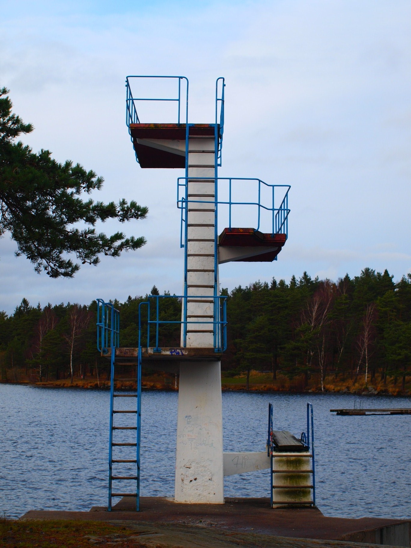
At the coordinates you'll find a rock face that is crucial to study closer for you to be able to answer some of the questions. On the coordinates for rock face two, you will find the answer to one of the questions. Here you'll also find a good place to take a swim, you have a sand beach and a rocky beach. You can also find some jetties, a jumping tower and a kiosk (open summer time only). Dogs are not allowed on this beach between may and september.
How to go to the EarthCache and log it:
You can park your car at one of the two parking lots. Parking lot 1 is sometimes closed, then parking lot 2 may be the best alternative (waypoints exist). If you want to use the bus, there is a bus station nearby named Kåsjön (waypoint exist)
To log the cache you have to send me the answers to the following questions. If you'd like you can also take a photo of yourself with Kåsjön behind you, and attach it to you log. This is not mandatory but it's always fun with foto logs. Some of the questions maybe difficult to answer if there is snow on the ground.
Question 1: What is the difference between the northern and southern rock face? Describe the difference and your thoughts about how the ice age shaped them.
Question 2: Standing at the coordinates, facing the jumping tower, what bearing are the glacial striations going? Answer in degrees
Question 3: In what direction are the rift valleys stretching? If you can't see it, you can try using satellite maps
Question 4: What type of rock are you standing on?
Send the answers to me at kajoluan@gmail.com. No need to wait for permission, I will contact you if something is wrong. Logs will be deleted if I get the wrong answer or no answer at all. Answers in the log will also be deleted.