Credits: Polish Geological Institute // Państwowy Instytut Geologiczny - Państwowy Instytut Badawczy
[PL]
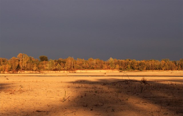
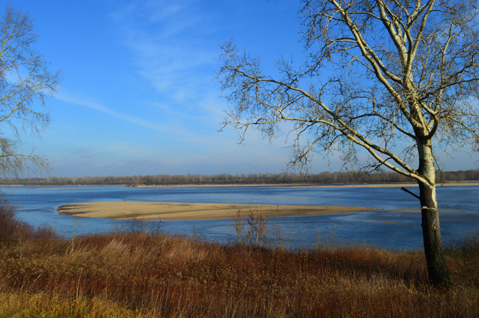
Poziom wody w Wiśle w roku 2012 jest rekordowo niski. Najniższy od połowy XVIII wieku, czyli od początku historii pomiarów hydrologicznych. Pod koordynatami tego earthcachea Wisła potrafi osiągać szerkość blisko kilometra. Obecnie - jesień 2012 - prawie 2/3 jej dna, w tym środek rzeki, są odsłonięte. Ciężkość terenu tego earthcachea wynosi "5" tylko i wyłącznie z racji nieosiągalności koordynatów podczas wyższego poziomu wody. Być może kolejny sezon umożliwiający zaliczenie tego EC nadejdzie za... kilka lub kilkadziesiąt lat? Tym samym The sands of the Vistula jest swojego rodzaju rarytasem.
Odsłonięcie dna ukazało piękny piach, którego nie powstydziłaby się niejedna bałtycka plaża. Jego inność można zauważyć już po kilku krokach spaceru po tutejszym dnie. Piach pod obuwiem sportowym lub górskim... skrzypi pod nogami podobnie jak śnieg zimą. Dzieje się tak za sprawą pewnego obficie tu występującego minerału (uwaga, to jedno z zadań!). Jego nazwa w starogermańskim oznacza zgrzyt, w starosłowiańskim twardy.
Skąd pochodzi piasek Wisły? Na to pytanie trudno dać jednoznaczną odpowiedź. Z jednej strony Wisła ma swoje źródła na zboczach Baraniej Góry, lecz wspomniany minerał transportowany jest jej dopływami również z Tatr. Ogólnie można więc powiedzieć, że częściowo pochodzi on z Karpat. Z drugiej strony środkowy i dolny bieg Wisły przechodzi przez tereny, gdzie nastąpiła akumulacja materiałów osadowych, naniesionych tu ze Skandynawii podczas ostatniego zlodowacenia. Piękno największej polskiej rzeki podkreśla więc swojego rodzaju paradoks: płynąca z południa na północ rzeka transportuje piach, który częściowo przybył z północy na południe.
Wiślane ławice piasku wędrują z prądem około 70 cm na dzień. O tym, jak potężne ilości materiału transportuje Wisła świadczy fakt, że w rejonie samej Warszawy wydobywa się około 1.400.000 ton piasku rocznie. Fakt ten jest poważnym zagrożeniem dla pięknych wysp, które można podziwiać w okolicy tego earthcachea. Ponieważ są one miejscem lęgowym ptaków siewkowatych wstęp na nie jest zabroniony.
 Vistuals riverbed in autumn 2012 & spring 2013 / photos & backgroundphoto: Hanbei
Odpowiedzi proszę wysyłać na mój profil GC. Nie trzeba czekać na odpowiedź, można od razu logować. Jeśli odpowiedź będzie niepoprawna, zgłoszę się sam. Pamiętajcie proszę, że logi bez podesłanych odpowiedzi będą kasowane.
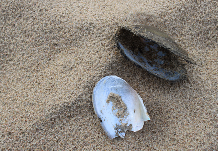 Anodonta anatina: jedno z twoich zadań / Anodonta anatina: one of your tasks / photo by Hanbei
ZADANIA:
- Pod koordynatami earthcachea stoisz na dnie Wisły. Jakiej wielkości są widoczne tu ziarnka piasku (mm)?
- Pewien minerał rzuca się szczególnie w oczy - jest odpowiedzialny za wspomniane skrzypienie - podaj jego geologiczną nazwę oraz jakiego jest koloru?
- Spacerując po piasku bez trudu natrafisz na muszle małży i ślimaków. Poszukaj gatunku Anodonta anatina (zdjęcie): jakiej wielkości są napotykane tu egzemplarze?
- Zakładając, że okruchy piasku jakie trzymasz w dłoni poruszały się ze średnią szybkością 70 cm na dzień: ile lat trwało, nim dotarły spod Baraniej Góry do Warszawy?
- Zadanie opcjonalne: spacerować po dnie Wisły i nie zrobić zdjęcia? No way ;)
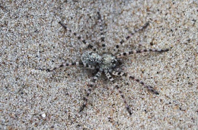 Arctosa cinerea, sometimes known as sand tarantula, one of the biggest european spiders - and Spider of the Year, 2007 - lives here too / photo: Hanbei
[DE]
Der Wasserstand der Weichsel ist im Jahre 2012 so niedrig, wie nie davor seit 1850, als die hydrologische Messung begann. Unter den Koordinaten dieses Earthcaches ist der Fluss normalerweise knapp 1 km breit. Momentan, später Herbst 2012 - sind 2/3 seines Bettes, inklusive dessen Mitte, freigelegt. Der Schwierigkeitsgrad dieses Earthcaches wurde nur aufgrund des jetzigen Wasserstandes vergeben. Bei einem höheren Wasserpegel wird es unmöglich sein, den EC erfolgreich zu loggen. Wer weiß, vielleicht kommt die nächste Gelegenheit dazu erst in... einigen Jahren? The sands of the Vistula bleibt damit eine Rarität.
Das freigelegte Flussbett zeigt einen wunderbaren Sand, den sich manch ein Ostseestrand wünschen würde. Da er besonders ist, merkt man schon nach ein paar Schritten. Hat man Sportschuhe an oder Wanderstiefel mit einer Vibram-Sohle, quietscht der Sand unter den Füßen, wie Schnee während einer Winterwanderung. Möglich macht dies ein Mineral, das hier in Übermengen vorkommt - damit ist auch eine deiner Aufgaben verbunden. Der Name des Minerals bedeutete im Altgermanischen quietschen (manche Quellen meinen: böses Erz, im Altslavischen hart.
Woher kommt der Weichselsand? Eindeutig lässt sich diese Frage nicht beantworten. Einerseits hat der Fluss seine Quellen in den Beskiden (an den Hängen des Barania Góra), andererseits kommt er mit anderen Zuflüssen aus anderen Karpaten-Regionen. Zum Teil also stammt er aus dem Gebirge im Süden. Gleichzeitig kommen die meisten sandigen Ablagerungen im Mittellauf der Weichsel aus dem weiten Norden. Die letzte Vergletscherungseriode Nordeuropas, die Weichsel-Kaltzeit, brachte den Sand aus Skandinavien. Weichsels Schönheit, des letzten großen, nicht geregelten Flusses in Europa, wird somit von einem Paradoxon unterstrichen: der vom Süden in den Norden fließende Fluss trägt mit sich einen Sand, der vom Norden in den Süden kam.
Weichsels Sandbänke wandern mit dem Strom mit einer Geschwindigkeit von ca. 70 cm pro Tag. Welche Mengen des Materials der Fluss mit sich trägt, zeigt die Tatsache, dass nur um Warschau jährlich knapp 1.400.000 Tonnen Sand abgebaut werden. Dies tut selbstverständlich den hier entstandenen Inseln - die man in der Nähe dieses Earthcaches bewundern kann - nicht gut. Da auf den Inseln seltene Wasservögel - Regenpfeiferartigen (Charadriiformes) - ihre Nistplätze haben, dürfen die Inseln nicht betreten werden.
Bitte, sendet eure Antworten mithilfe meines Profils. Ihr dürft direkt loggen, ohne meine Antwort abzuwarten. Sollten eure Antworten falsch sein, melde ich mich. Bitte denkt dran: Log-Einträge ohne die abgesandte richtige Antwort-E-Mail werden gelöscht.
AUFGABEN:
- Bei den Koordinaten stehst du auf dem Weichsel-Flussbett. Wie groß sind die hiesigen Sandkörner (mm)?
- Ein hier sehr oft vorkommendes Mineral sticht besonders in die Augen und ist wie das erwähnte Quietschen verantwortlich - nenne seine geologische Bezeichnung und seine Farbe
- Spaziert man hier ein wenig herum, findet man viele Muscheln vor. Suche nach der Anodonta anatina (Bild): wie groß sind hier die meistens anzutreffenden Exemplare?
- Nehmen wir an, der Sand, den du in der Hand hältst, bewegte sich mit einer konstanten Geschwindigkeit von 70 cm pro Tag: wie lange brauchte ein Korn, um von Barana Góra in den Beskiden bis nach Warschau zu kommen?
- Optional: ein Bild vom Weichsel-Flussbett ist doch ein Muss: ja oder doch? ;)
[EN] - Yuriko translates my earthcaches into English. You can ask her for help too ;) Yuriko, big thanks for your perfect support ;)
Recently, the declining water levels in the Vistula River have nearly reached all-time lows. This hasn't occurred since the middle of the 18th century, when the hydrological measurements were carried out for the first time. Here, where the coordinates brought you, the river can be almost 1 km wide. At the moment (autumn of 2012) almost two thirds of the riverbed (including the middle) is bare. The difficulty of the cache is set to "5", because higher water levels make the site inaccessible. The next chance of completing this eartcache may come in many years; this makes this earthcache so unique.
There is beautiful sand on the bare riverbed. However, as you may notice, it's a very specific type of sand. It crunches under your shoes, making a sound similar to that made by snow. A certain mineral is responsible for this sound. Which one? You will have to find out for yourself (see the tasks below). Its name is derived from an Old German word meaning rasp (hard in Slavic languages).
Where do the sands of Vistula come from? It's difficult to give a simple answer to this question. The river takes its source from the slopes of Barania Gora; however, the sediments are transported also by Vistula's tributaries from the Tatra Mountains. In general, we can say that the sands partially originate from the Carpathians. On the other hand, the middle and lower course of the river pass through areas particularly rich in sediments accumulated during the last glaciation. So there is a certain paradox about this beautiful river: it flows from south to north, transporting sand which had earlier traveled from north to south. The sandbanks are carried by the current for about 70 cm a day. The overall amount of sand carried by Vistula River is immense - over 1.400.000 tonnes of it are extracted annually only in the closest proximity of Warsaw. This kind of activity is particularly harmful to the picturesque islands located near this earthcache. Since they are a shorebird nesting site, the islands are closed to the public.
Replies are to be sent via my profile. There’s no need to wait for my reply, you can log your answers straight away. If there’s anything wrong, you will be notified. Do remember though, that logs with no answers shall be deleted.
TASK:
-
The coordinates of this eartcache lead to the riverbed. Estimate the size of the sand grains here (in millimeters)
-
What is the name and colour of the mineral responsible for the crunching sound made by sand?
-
You can notice numerous mussels and snails' crusts in the sand. Search for a specimen of Anodonta anatina (see the picture) and estimate its size.
-
Assuming that the sand grains were traveling at an average speed of 70 cm a day, how long did it take for them to be transported from Barania Gora to Warsaw?
- Optional task: to stand on the Vistula`s riverbed and not to take a photo? ;)
Earthcaches are cool, just think and cache them ;)) )")