The beauty of the park is enhanced by the spectacular series of foaming falls which were created by the dark, rushing waters of the Tygart Valley River and provides a boundary between Marion and Taylor counties. The prevalent rock formation known as Connoquenessing Sandstone, forms the cap of the falls over which the river plunges and swirls and appears both as ledges and huge room size boulders for over a mile down the narrow canyon floor.
The Tygart Valley River — also known as the Tygart River — is a principal tributary of the Monongahela River, approximately 135 miles (217 km) long, in east-central West Virginia, USA. Via the Monongahela and Ohio rivers, it is part of the watershed of the Mississippi River, draining an area of 1,329 square miles (3,440 km2) in the Allegheny Mountains and the unglaciated portion of the Allegheny Plateau. The Tygart Valley River rises in the Allegheny Mountains in Pocahontas County and flows generally north-northwestwardly through Randolph, Barbour, Taylor and Marion counties, past the towns of Huttonsville, Mill Creek, Beverly, Elkins, Junior, Belington, Philippi, Arden, and Grafton, to Fairmont, where it joins the West Fork River to form the Monongahela River. The elevation at the start of the river is 4540 ft. At the mouth where it meets the Monongahela River is 863 ft.
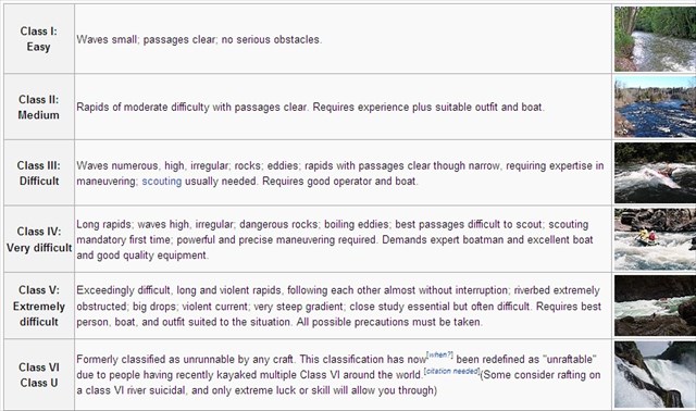
In 1964, the state park system acquired the falls and the surrounding land. This picturesque river gorge became Valley Falls State Park. Because of the rock formations at the falls and the rapids as far as the eye can see from the posted coordinates, the Tygart River is a popular spot for visitors to engage in water activities. Below is a chart of the International Scale of River Difficulty to help you understand the force of the river.
To qualify for this earthcache, please email the answers to the following questions:
1. What type of rock form the Connoquenessing Sandstone?
A. Igneous
B. Sedimentary
C. Metamorphic
2. At the point of the posted coordinates, give an estimation of the width of the Tygart River that forms the falls and estimate the height of the falls.
3. From the start of the Tygart River to the mouth where it ends, what is the elevation change per mile? This can be calculated from the information given above.
4. Standing at the posted coordinates and looking at the waterfall, how many of the rock formations break up the waterfall from one side of the river to the other?
A. 0
B. 3
C. 7
D. 12
5. According to the International Scale of River Difficulty above and standing at the posted coordinates looking at the falls and the rapids formed from the rock formations, what category of river difficulty would you place the Tygart River?
It is not required but a photo at the falls of you or your GPS in your log is encouraged.
Congrats to Clive and Juliana for the FTF!!!