Le Mont Lassois EarthCache
-
Difficulty:
-

-
Terrain:
-
Size:  (not chosen)
Please note Use of geocaching.com services is subject to the terms and conditions
in our disclaimer.

Une butte témoin
Le Mont Lassois est une butte témoin dans la vallée de la Seine à l'endroit où ce fleuve perce la côte châtillonnaise pour continuer son cours vers Paris. Formé du Mont Roussillon et du Mont Saint-Marcel, il est situé à 6 km au nord-ouest de Châtillon-sur-Seine dans le département Côte-d'Or.
On utilise le terme de butte témoin du fait qu'il s'agit d'un relief séparé du plateau par l'érosion et qui prend ainsi l'aspect d'une colline isolée. La côte constitue une des nombreuses couches calcaires du bassin parisien.
Dans la région de Châtillon-sur-Seine, ces couches calcaires ont livré et livrent toujours des pierres jouant un rôle important pour l’économie. Les calcaires ferrugineux sont à l'origine d'industries; les calcaires durs exploités au sud de Châtillon-sur-Seine furent utilisés pour de grands ouvrages.
Depuis l'âge des métaux, le Mont Lassois a été occupé par l'homme en raison de ses avantages stratégiques avec un grand potentiel défensif grâce aux remparts et fossés au relief de la Seine. Il s'agit également d'une position géographique clé, étant donné que les axes de communication, alignés sur le cours des fleuves, passent au pied du Mont Lassois pour relier les pays méditerranéens au nord de l'Europe (axe Seine-Saône-Rhône). Déjà pendant la protohistoire, le village de Vix contrôlait le point à partir duquel la Seine devient navigable.
C'est en 1953 qu'y fut découvert le cratère de Vix, un grand vase à boire de bronze datée d'environ 510 av. J.-C., haut de 1,64 mètres, pesant 206,8 kg et d'une capacité de 1.100 litres. Il se trouve exposé au Musée du Pays Châtillonnais à Châtillon-sur-Seine.
Pour pouvoir logger cette cache, vous devez consulter les panneaux explicatifs et répondre aux questions suivantes:
- Quels sont les altitudes respectives du Mont Roussillon et du Mont Saint-Marcel?
- Dans quelle ville sont situées les carrières exploitant les calcaires ferrugineux?
- Énumérez au moins trois monuments où on trouve les calcaires durs exploités au sud de Châtillon-sur-Seine!
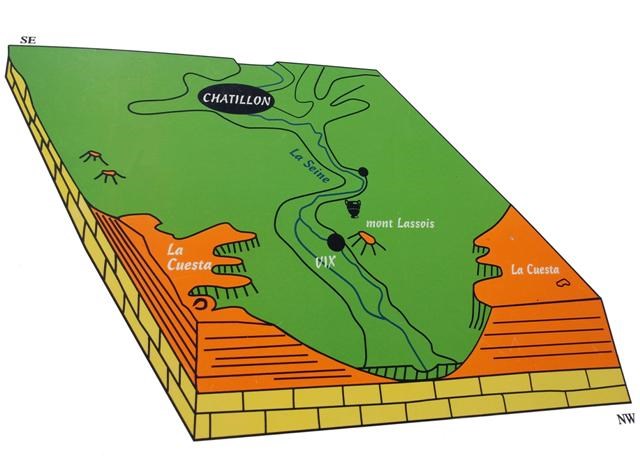
- Quel est le nom des deux collines dans la partie gauche de la carte géologique?
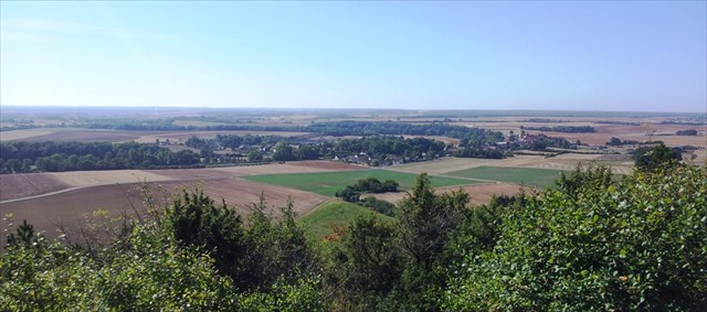
- Estimez la différence en altitude entre votre position et la plaine devant vous!
Faites s.v.p. un courriel avec vos réponses à cette adresse (et non pas par l'adresse de mon profil!), avant de logger.
Si vous voulez, vous pouvez poster avec votre log une photo vous montrant avec votre GPS devant le panorama (facultatif).

Outlier
Mount Lassois is a small hill in the Seine valley at the point where the river cuts through the slope of the Châtillon hills on its way to Paris. Composed by the Mount Roussillon and the Mount Saint-Marcel, it is situated 3.7 miles north-west of Châtillon-sur-Seine in the département Côte-d'Or.
The term outlier describes a mass of rock which is separated from a plateau by erosion, taking the aspect of an isolated hill. The hillside constitutes one of the many limestone strata of the Paris Basin. In the region of Châtillon-sur-Seine, this limestone has played and is still playing an important role in the economic life. Industries have grown out of the iron-bearing limestone; the hard limestone extracted south of Châtillon-sur-Seine is to be found in important monuments.
Since the age of metals, Mount Lassois has been occupied by humans due to its strategic advantages with strong defensive potential due to the ramparts and trenches and the relief of the river Seine. It also holds a strong geographical key position, as the communication routes, following the course of the rivers, pass at the foot of Mount Lassois linking the Mediterranian countries to the north of Europe (Seine-Saône-Rhône connection). During ancient times, the village of Vix controlled the point where the river Seine becomes navigable.
In 1953 was found there the 'Vase de Vix', a huge bronze crater dating from around 510 B.C., 64.5 ft high, weighing 455.9 pounds with a capacity of 290.59 US liquid gallons. It is exhibited in the Museum of Châtillon-sur-Seine.
To be allowed to log this cache, you have to refer to the information panels and answer the following questions:
- What are the heights above sea level of Mont Roussillon and Mont Saint-Marcel?
- In what city are located the quarries exploiting the iron-bearing limestone?
- List at least three monuments where you can find the hard limestone extracted south of Châtillon-sur-Seine!
- What is the name of the two hills in the left part of the geological map?
- Estimate the difference in height between your position and the lowland in front of you!
Please mail your answers to this address (and not using my profile's mail address!) before logging.
You are welcome to post a picture of you with your GPS showing the panorama (optional).

Ein Erdkegel
Der Mont Lassois ist eine Erhebung im Tal der Seine, dort wo der Fluss die Steilstufe von Châtillon-sur-Seine durchbricht um ihren Weg nach Paris fortzusetzen. Bestehend aus dem Mont Roussillon und dem Mont Saint-Marcel liegt er 6 km nordwestlich von Châtillon-sur-Seine im Departement Côte-d'Or.
Man spricht von einem Erdkegel, da die Bodenerhebung durch stetige Erosionsprozesse von der Hochfläche getrennt wurde und so die Form eines eigenständigen Hügels annahm. Die Steilstufe besteht aus den kalkhaltigen Steinschichten des Pariser Beckens.
In der Region um Châtillon-sur-Seine haben diese kalkhaltigen Steinschichten seit immer, und auch heute noch, Steine geliefert und so eine wichtige wirtschaftliche Rolle gespielt. Die eisenhaltigen Kalksteinschichten legten den Grundstein der ersten Schwerindustrien; die härteren Steinschichten lieferten Baumaterial für zahlreiche Baudenkmäler.
Schon in der Bronze- und Eisenzeit war der Mont Lassois besiedelt wegen seiner großen strategischen Bedeutung mit eindeutig defensivem Charakter dank der natürlichen durch die Seine begrenzten Steilstufen. Es handelt sich ebenfalls um eine geografische Schlüsselstellung, da die entlang den Flüssen verlaufenden Verbindungswege am Fuß des Mont Lassois vorbei führen um die Mittelmeerländer mit dem Norden Europas zu verbinden (Seine-Saône-Rhône-Achse). Schon in vorgeschichtlicher Zeit kontrollierte der Ort Vix die Seine welche ab diesem Punkt schiffbar wurde.
Im Jahr 1953 entdeckte man hier die Bronze-Amphore von Vix welche auf ca. 510 v. Chr. datiert wurde. Sie ist 1,64 Meter hoch, wiegt 206,8 Kilogramm uns fasst 1.100 Liter. Sie ist im Museum in Châtillon-sur-Seine ausgestellt.
Um diesen Cache loggen zu dürfen, müsst ihr die Informationstafeln aufsuchen und forlgende Fragen beantworten:
- Welches ist die Höhe über NN des Mont Roussillon und des Mont Saint-Marcel?
- In welcher Stadt befindet sich der Steinbruch der eisenhaltigen Kalksteinschichten?
- Nennt wenigstens drei Baudenkmäler in welchen man die härteren Kalksteine findet, welche südlich von Châtillon-sur-Seine abgebaut werden (Steinbruch von Chamesson)!
- Wie heißen die beiden Hügel im linken Teil der geologischen Karte?
- Schätzt den Höhenunterscheid zwischen der Stelle wo ihr steht und der umliegenden Ebene!
Sendet bitte eure Antworten an diese Adresse (und nicht über meine Profil-Adresse) bevor ihr euren Log schreibt.
Wenn ihr möchtet, könnt ihr gerne ein Bild von euch und eurem GPS vor dem Panorama in euren Log setzen (freiwillig).
Additional Hints
(No hints available.)