Champagne is part of the Paris basin, an old maritime depression dating from the Mesozoic and tertiary era which formed a sedimentary basin . This basin is made of successive terraces which curve alongside into a semicircle, from the tertiary core of the Ile-de-France to the borders of the Ardennes’ and Vosges ‘old massifs . Geological rings of different ages can be found ; they are older and older as one goes nearer the oriental border of the basin.
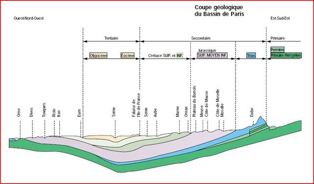
The main part of the vineyard in Champagne follows along 125 kms the irregular line of the coast called Falaise de l’Ile-de-France (from l’Aisne, to the north-west of Rheims to the Seine in Nogent).It is cut from North to South by the Valleys of la Vesle, l’Ardre, la Marne, le Surmelin, and les Marais de Saint-Gond. The summit of the coast is the limit of the tertiary zone and it rises 120 meters over the dry Champagne (a chalky champaign that Michelet called the desertof the Champagne ”pouilleuse.”)
The subsoil :
In Champagne, for the vine the subsoil is much more important than the soil itself., which is not the case for other vineyards such as the vineyard of Burgundy. It is especially true for the platform of the Mesozoic era on which stands the Falaise de l’Ile-de-France and where the subsoil is made of the belemnitelle chalk (belemnitella quadrata being fossils that can sometimes be found )
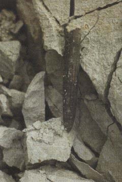
Belemnite
During the Mesozoic era , 90 million years ago, when the sea covered everything, sediments went down onto the ocean floor and created a 200 meters high layer .
In Champagne, the showing sediments are calcareous up to 75% .It is a material which can be split up and favors the soil drainage which is good for the vine.
The vines from the Champagne area like chalk. It absorbs heat and gives it back.
It is the same with water and its retention strength being less than the sucking strength of the vine stock , it regulates its absorption by the vine which plunges its roots to 3 or 4 meters deep , sometimes even more .Thanks to its important porosity it is a great water tank ( 300 to 400 litres for 1 m3) which gives to the plant enough water even during the driest summers.
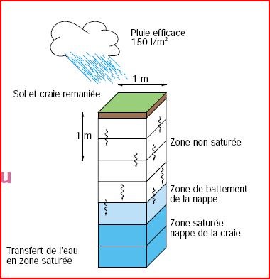
Penetration of the water
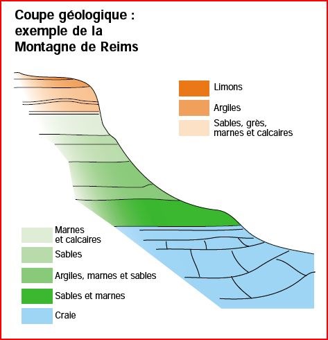
Geologic cup of the mountain of ReimsThe subsoil nature guided the vine stocks choice in the Champagne area. Three vine stocks have well adapted : the black pinot, the chardonnay and the black meunier. Chaptal had already noticed this when he wrote in 1819 : In champagne, the grounds are usually good for vines are on chalk layers ; it does well there.
In the part of the Marne valley located on the west side of the Falaise de l’Ile-de-France, the subsoil is often ixed with the soil, the whole giving sandy lands with a content of chalk which can be more than 20%. In l'Aube, the subsoil is made of marly chalk . They are similar to the Chablis area, they give good lands for vines. Villenauxe-la-Grande is an exception, even if it is on the border of the Falaise de l'Ile-de-France, and , on the west side of Troyes.
To validate this EarthCache you must answer the following questions:
1) Evaluate the average height of the cliff in front of you,
2) How much coccoliths correspond to this thickness?
3) What was the position of this site 145 million years ago? (xx parallel line)
(Optional) once the validated answers you can put a photo of you in the point of coordinates.