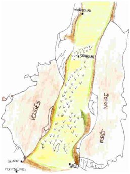
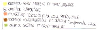
L'histoire du pétrole commence au tertiaire, plus précisément à l’oligocène (de -34 à -23 millions d'années). A cette époque, la mer envahit le futur fossé rhénan . A ce moment là il s'agit d'un chenal en voie d'effondrement sur un axe Nord-Sud. Les Vosges et la Forêt Noire s'élèvent par à-coups . Le fossé se remplit de plus en plus de séries marneuses. Au sud du fossé rhénan l'affaissement est peu important. Une succession de périodes d'affaissement et d'évaporation donne naissance à des évaporites : ces séries marines peuvent contenir du sel. L'érosion décape les massifs qui s'élèvent, les cours d'eau transportent les matériaux et forment des dépôts détritiques (conglomérats et grès): les conglomérats côtiers visibles dans la région de Bouxwiller (cf. caches GC2A2PBet GC1JNXF)
A l’époque on y trouvait des êtres vivants, animaux et végétaux essentiellement planctoniques. Le dépôt de ces organismes au fond de l’océan à leur mort, produit des déchets organiques qui s’accumulent au fond de la mer. A cet endroit, ils se mélangent à des sédiments.
Deuxième étape : la maturation de cette matière organique
Commence alors une lente transformation: l’enfouissement des sédiments fait que ces sédiments sont comprimés et subissent un échauffement. On obtient alors le kérogène, un « extrait sec » disséminé dans la roche sous forme de petits grumeaux. Le kérogène produit du pétrole et/ou du gaz naturel, qui sont des matières plus riches en hydrogène, selon sa composition et les conditions d’enfouissement. Si la pression devient suffisante ces fluides s’échappent, ce qu’on appelle la migration primaire. En général, la roche source a plusieurs dizaines, voire centaines de millions d’années quand cette migration se produit. Le kérogène lui-même reste en place, appauvri en hydrogène. Le liquide issu de ces transformations est moins dense que les roches environnantes, il quitte alors la roche mère et migre vers la surface.
Troisième étape : le piégeage des hydrocarbures.
Cette migration est généralement bloquée quand les hydrocarbures rencontrent une couche imperméable, en l’occurrence de l’asphalte. Les hydrocarbures vont s'accumuler dans des poches de roche poreuse appelée roche réservoir ou encore "roche magasin" (qui est le grès de Vosges pour ce gisement) ou lentilles.
C’est lorsque ces couches supérieures cassent suite à des failles que peuvent, comme ici apparaître des résurgences naturelles.
Avant de logger cette cache vous devez répondre à ces 3 questions :
1) Comment appelle-t-on les roches magasins les plus importantes en Alsace du Nord ? La couche de… (du nom d’une localité proche)
2) De que ère fait partie l’oligocène ?
3) A l’aide d’un bâton mesurez la profondeur approximative de la couche au point le plus profond (10 cm, 50 cm ou 1 mètre ?)
Non obligatoire : une photo de vous devant la marre (il n’est pas utile et peu recommandé de s’y baigner)
ATTENTION DANGER : Les traces de pétrole laissées par les animaux sur les végétaux aux alentours de la marre peuvent avoir des conséquences fatales pour vos beaux habits du dimanche… L’owner se décharge de toute responsabilité.
It is about a natural oil flush from the geologic formation specific to the plain of Alsace.
Alsace is one of the oldest oil-producing regions in Europe. The presence of oil is manifested since the antiquity by bituminous emergences that still exist in some parts of the forest ofHaguenau. Pets and men have always been attracted to these oiled pools. Sinceages toothaches, gout or wounds were treated with this oil coming up from the earth. Still in those days there are wild boars coming to get rid of the vermin.
Oil is a product of the geological past of the region, from the succession of three quite exceptional circumstances.
First step: the accumulation of organic matter
The oil story startsatthe tertiary era, specifically at the Oligocene (from -34 to -23 million years). At that time, the sea invaded the future Rhine Graben. At that time it is wasa channel on the way of collapsing on a north-south axis. The Vosges and the Black Forestrise up discontinuously in the sky. The gap fillsup with more marly series. South of the Rhine Graben,the subsidence is less. A succession of periods of subsidence and evaporation gives rise to evaporite: marine series ableto contain salt. The erosion scours the rising mountains, rivers transport the materials and form those detrital deposits (conglomerates and sandstones): the coastal conglomerates … visible in the area of Bouxwiller (refer to caches GC2A2PBet GC1JNXF)
At that time there was living beings, animals and plants mostly plankton. The deposition of these organisms at the bottom of the ocean when they die, produces organic waste that accumulates at the bottom of the sea. At that place, they mix with sediment.
Second step: the maturation of these organic matter
Now starts a slow transformation:the burial of the sediments brings them to compress and to undergo a heating. So appears the kerogen, a "dry" disseminated in the rock in the form of small lumps. Kerogen produces oil and / or natural gas, which are substances rich in hydrogen, depending on its composition and burial conditions. If the pressure becomes sufficient fluids escape, that is called the primary migration. In general, the source rock has dozens or even hundreds of millions of years when the migration occurs. Kerogen itself remains in place, depleted in hydrogen. The liquid from these transformations is less dense than in the surrounding rocks, it leftsthen the rock and migrates to the surface.
Third stage: the trapping of the hydrocarbons.
This migration is usually blocked as soon as the hydrocarbons encounter an impermeable layer, in fact asphalt. Hydrocarbons will accumulate in pockets of porous rock called reservoir rock or "rock shop" (which is the Vosges sandstone for this deposit) or lenses.
It is when these upper layers break due to reefs that may appear like here natural resurgences.
Before logging this cache you needto answer these three questions:
1) How do you call the most important rock stores in Northern Alsace? Layer of ... (the name of a nearly town)
2) From Era is Oligocene a part of?
3) With the help of a stick measure the approximate depth of the layer at the deepest point (10 cm, 50 cm or 1 meter?)
Not required: a picture of you in front of the pond (it is not necessary and not recommended to swim there)
WARNING: The oil traces left by animals on plants around the pond can have fatal consequences for your Sunday best clothes ... The owner disclaims any responsibility.
Es handelt sich hier um ein natürlicher Ölaufschluss der entstand von der einzigartig geologische Formation der Ebene des Elsass.
Das Elsass ist eine der ältesten Ölproduzierenden Regionen Europas. Das Vorhandensein von Öl wird seit der Antike von bituminösen Aufschlüssen, die es noch immer in einigen Teilen des Waldes von Haguenau gibt. Tiere und Menschen waren noch immer von diesen ölige Teichen angezogen. Seit langer Zeit behandelt man Zahnschmerzen, Gicht oder Wunden mit Öl dass aus der Erde kommt. Heute noch suhlen sich Wildschweine in diesem Schlamm um sich von dem Ungeziefer loszuwerden.
Öl ist ein Produkt der geologischen Vergangenheit der Region, aus der Abfolge von drei ganz außergewöhnliche Umstände.
Erster Schritt: die Akkumulation von organischem Material
Diese Öhlgeschichte beginnt im Paläogen, genau im Oligozän (-34 bis -23 Millionen Jahre). Damals füllt das Meer die zukünftige Rheinebene. Die Vogesen und der Schwarzwald erheben sich langsam. Die Lücke füllt sich mehr und mehr mit Mergel. Südlich des Rheins Graben ist die Senkung ist geringer. Eine Reihe von Perioden von Senkungen und Verdunstung führt zu Evaporit: die Marineserie können Salz enthalten. Die Erosion nagt die die wachsenden Bergen ab, die Flüsse versetzen Stoffe und begaben sich zu detritischen Ablagerungen (Konglomerate und Sandsteine) Küstenkonglomerate sichtbar in der Region Bouxwiller (vgl. geocaches GC2A2PBet GC1JNXF)
Zu der Zeit gab es Lebewesen, Tiere und Pflanzen vor allem Plankton. Die Abscheidung dieser Organismen am Meeresboden, wenn sie sterben, produziert organische Abfälle, die sich am Boden des Meeres ansammeln. Dort werden sie mit Sediment gemischt.
Zweiter Schritt: Reifung des organischen Materials
Beginnt eine langsame Transformation. Die begrabenen Sedimente werden komprimiert und wärmen. Dann bildet sich Kerogen, ein "trockenes extract" das sich im Felsen als kleine Klümpchen verbreitet. Kerogen produziert Öl und / oder Gas, welche Substanzen reich an Wasserstoff, je nach ihrer Zusammensetzung. Wenn der Druck ausreicht entweich diese Flüssigkeit . Das ist die sogenannte primäre Migration. Im Allgemeinen wenn die Migration erfolgt ist das Muttergestein Dutzende oder sogar Hunderte von Millionen Jahren alt. Das Wasserstoffarme Kerogen bleibt am Platz. Die Flüssigkeit aus diesen Veränderungen ist weniger dicht als das umliegenden Gestein. Es verließ das Muttergestein und wandert an die Oberfläche.
Dritter Schritt: das Einfangen von Kohlenwasserstoffen.
Diese Migration wird blockiert, wenn Kohlenwasserstoffe an eine undurchlässige Schicht stossen, nämlich Asphalt. Kohlenwasserstoffe werden sich in Ablagen von poröses Gestein namens Lagergestein (der Vogesen-Sandstein) oder Kontaktlinsen akkumulieren.
Wenn diese oberen Schichten aufgrund von Brüche brechen, dann kann, so wie hier, zu natürliche Öhlquellen kommen.
Bevor Sie diese Cache loggen müssen Sie folgende Fragen beantworten :
1) Wie nennt man die grössten Lagergesteine in Nord-Elsass . Die ….Schicht (der Name einer Stadt in der Nähe)
2) Zur welcher Ära gehört Oligozän?
3) Mit Hilfe eines Stock messen die ungefähre Tiefe der Schicht an der tiefsten Stelle (10 cm, 50 cm oder 1 m?)
Nicht erforderlich: ein Foto von Ihnen vor dem Teich (es ist nicht notwendig und wird nicht empfohlen zu schwimmen)
ACHTUNG: Die Öl-Spuren von Tieren auf Pflanzen rund um den Teich können fatale Folgen für ihre sauberen Sonntagskleider verursachen ... Der Besitzer übernimmt keine Verantwortung.
