|
 |
|
 |
|
 |
|
|
docyrcat |
|
oceanmaster30 |
|
Franky84 |
|
Gardez l'équilibre
FRANÇAIS
|
|
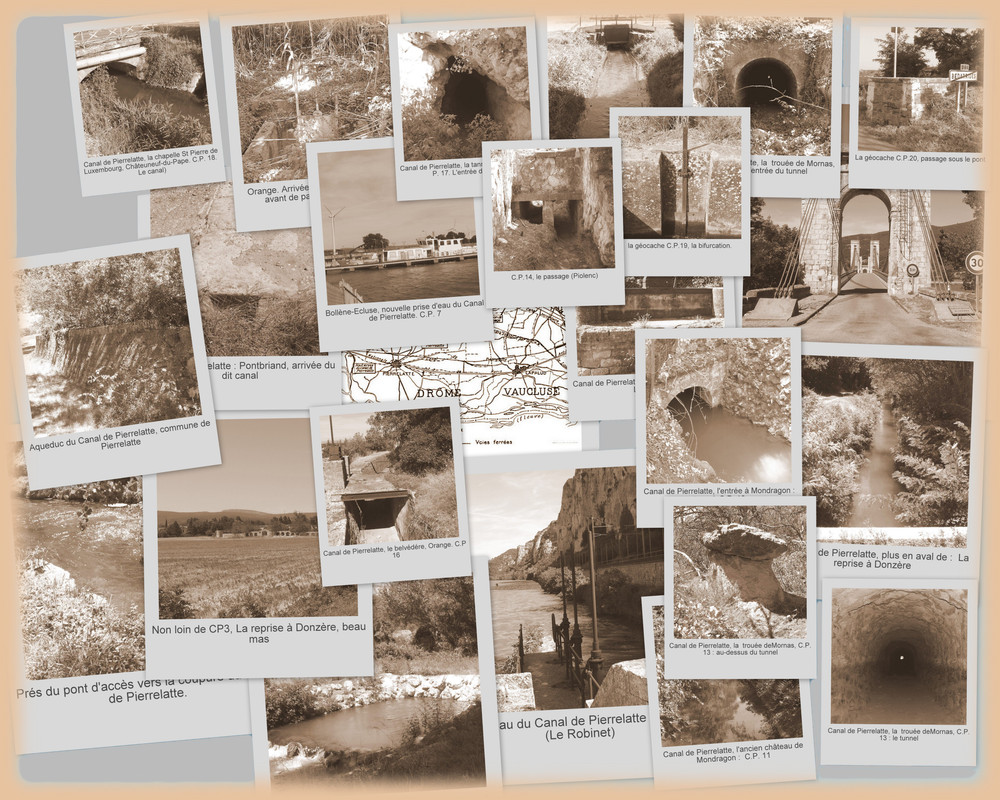
Commencé dans la deuxième moitié du XVIIème siècle, le canal de Pierrelatte est le plus ancien canal de dérivation des eaux du Rhône et l’un des premiers réseaux d’irrigation installé dans la vallée. Suite à la construction du canal du Rhône, il récupère les eaux du Rhône depuis le canal de Donzère-Mondragon, au niveau de Bollène, et irrigue les plaines de Mornas, Piolenc, Orange et Chateauneuf-du-Pape jusqu’à l’Ouvèze qu’il rejoint au sud de Bédarrides. Initié par le Prince de Conti, son premier concessionnaire, le canal est ensuite passé de main en main de nombreuses fois. L’entretien de ses 77,5 kms de longueur et de ses 45 ouvrages d’art représentait une charge trop lourde au regard des surfaces qu’il irriguait : moins de 1% de son potentiel sous le Second Empire… Depuis les aménagements de la CNR, le canal principal ne mesure plus que 54,5 km, et il est ensuite tombé en désuétude à la fin du XXème siècle.
|
Sur la commune d'Orange, le canal de Pierrelatte se fraye un chemin en contournant la ville puis passe par le quartier du Grès et longe le petit massif collinaire vers Châteauneuf-du-Pape.
Ici vous pourrez apprécier le travail réalisé : percement de la roche (assez friable) et création d'un chemin qui sert de soutènement. Ce chemin semble entretenu.
Cette petite série de 21 géocaches vous permet de voir les réalisations humaines pour amener l'eau, source de vie et de gains pour les paysans et les agriculteurs du Tricastin et ensuite de l'Orangeois de l'Eygues à l'Ouvèze et ce à partir du XVIIIème jusqu'au milieu du XXème siècle.
Bonne découverte.
Cache : Petite boîte plastique, pas de crayon
ENGLISH
|
|
Started in the second half of the seventeenth century, the Pierrelatte Channel is the oldest floodway waters of the Rhone and one of the first irrigation installed in the valley. Following the construction of the Canal du Rhône, it retrieves the waters from the Donzère-Mondragon channel, in the town of Bollène, and irrigates the plains Mornas, Piolenc, Orange and Châteauneuf-du-Pape until he joins the river Ouvèze in the south of the city of Bédarrides.
Initiated by the Prince de Conti, his first dealership, the channel is then passed from hand to hand many times. Maintaining its 77.5 km length and its 45 structures represented a heavy burden in terms of irrigated surfaces that less than 1% of its potential under the Second Empire ...
Since the facilities of the CNR, the main channel measures only 54.5 km, and then fell into disuse in the late twentieth century.
|
In the town of Orange, the Pierrelatte Channel makes its way in and around the city and then trough Grès district and along a small hill to Châteauneuf-du-Pape.
Here you can enjoy the work : digging the rock (brittle enough) and create a path that is retaining. This path seems maintained.
This small series of 21 caches you can see human achievement to bring water, source of life and gains for paesants and farmers from the Tricastin and then the Orange'area (the Eygues river to Ouvèze river)) and this from the eighteenth to the mid-twentieth century.
Good discovery.
Cache : Small plastic box, no pen.