A’a Lava Glacial Erratic.
Volcanoes in Michigan!? Giant mile high ice fields!? There is evidence of both found in giant boulders, right in Downtown Houghton,Michigan. How can they help explain our geologic past and why these resources are important to humans?
Location: Franklin Square, Downtown Houghton. There is a parking lot nearby at a coffee shop/bookstore. Please be careful of traffic while crossing any roads on your way to this EarthCache.
Cache Coordinates: N 47o 7.294’ W 88o 33.761’
EarthCache Description:
How do these features help explain our geologic past and why are these resources important to humans?
There is no more spectacular site than an erupting volcano. Imagine watching the largest lava flow ever recorded – which can be found in an area currently known for its huge lake, snow and evergreens-Michigan’s Upper Peninsula. More precisely, the Keweenaw Peninsula.Approximately 1.1 billion years ago, during the Precambrian period, huge rifts in the earth’s crust began to form in what is now Lake Superior. These ancient flows formed thick layers up to 1,200 feet in a single flow. *
In figure 1 you can see fresh lava called a’a (pronounced ah ah). As this a’a lava flowed over the older flows, broken fragments from the cooled surface are mixed in with the lava creating a jagged surface with sharp edges that can be hard to walk on. When the lava hardens, you can see these pieces incorporated into the boulder. These are referred to as clasts. (See Fig. 2). If you look closer, you can see small bubbles and holes. Over time, these small holes called vesicles may be filled with other minerals like copper. This is known as porphyry copper deposit and is what led the miners to come to northern Michigan.
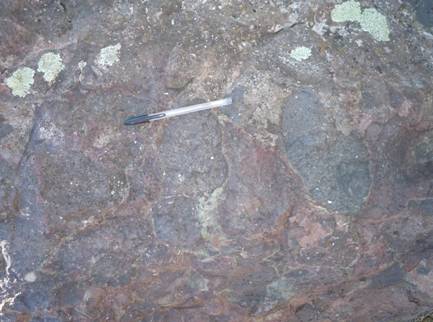 Figure 2. Close-up of lava fragments or clasts in an a’a boulder.
(Note: green blobs are lichen, not part of the rock). Photo by: K. Koch
Figure 2. Close-up of lava fragments or clasts in an a’a boulder.
(Note: green blobs are lichen, not part of the rock). Photo by: K. Koch
After a billion years of being buried under other rock layers, imagine a giant
continental sheet ice thousands of feet thick ripping up these volcanic rocks and depositing them miles away. This process is known as
glacial plucking (see Fig 3) As the continental glaciers which had covered much of North America melted away, they deposited large boulders or
erratics along with other types
glacial drift.
 Figure 3. Diagram of glacial abrasion and plucking.
Source: http://en.wikipedia.org/wiki/Glacier
Figure 3. Diagram of glacial abrasion and plucking.
Source: http://en.wikipedia.org/wiki/Glacier
Both volcanic and glacial features are useful resources to humans. Many of the Keweenaw volcanic deposits were eventually mined for their copper ore and other mineral resources. Glacial deposits were used for sand and gravel to make the local roads and bridges. Finally, some of these erratics were found in the glacial deposits nearby and were moved by man. Here, they provide a glimpse into the history of the Keweenaw region.
*Footnote:
The mid-continent rift formed about 1100 Ma (million years ago) in the Precambrian. It extends from northern Kansas to Lake Superior, where it sharply turns south to the lower peninsula of Michigan. Toward the center of the rift, the thickness of the volcanic rocks reaches 25kilometers. Source:
http://www.minsocam.org/msa/collectors_corner/vft/mi2b.htm)
Log in Questions:
1. Describe the size, shape, color, and features of the glacial erratic found in Franklin Park.
2. How does the presence of bubbles and clasts in the boulder provide evidence of its origin?
3. What does this “erratic” from a rock layer found miles away in piles of sediment debris indicate how Michigan’s geologic history has changed over time?
4. How does the statue of the miner on one of these lava rock boulders help demonstrate the interactions between humans and the Earth’s resources?
Bonus Question:
What special about the shape is the clast found in the erratic in Figure 5?
(Hint: The hand below is making the same shape of this local landform)
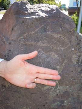 Figure 4. An interesting shaped clast in an a’a erratic. (Look above the hand!)
Photo by K. Koch
Figure 4. An interesting shaped clast in an a’a erratic. (Look above the hand!)
Photo by K. Koch
________________________________________________________________________
Earth Science Literacy Principles:
Big Idea #4 Earth is continuously changing
4.1 Landscapes result from the dynamic interplay between processes that form and uplift new crust and processes that destroy and depress the crust.
Both of these dynamics are evidenced by the erratic which was formed as new crust and destroyed (broken-up and moved) by glacial activity. Understanding this interplay helps to better interpret Michigan’s landscape.
Earth Science Lesson Topics/Objectives:
1. Michigan’s landscape has changed numerous times in the past.
2. There are interactions between spheres (geosphere and hydrosphere)
3. Man uses Earth’s resources for many activities.
Common Earth Science Misconceptions:
1. All rocks and planets were formed at the same time.
2. The Earth has always been pretty much the way it is now.
3. Glaciers are only ice and snow layers which are not very thick.
4. Glaciers have not covered Michigan for millions of years.
In this EarthCache, visitors will observe a glacial erratic which was most likely deposited near the end of the Wisconsin glacial period. According to evidence provided from dating a buried forest near Marquette, the last glacial advance occurred approximately 11,500 years ago. The erratic was deposited in the glacial till after the ice retreated less than 10,000 years ago. Therefore, this glaciers were part of Michigan’s landscape a relatively (geologically speaking) short time ago which challenges the misconception that “Glaciers have not covered Michigan for millions of years”.
____________________________________________________________________________________________________________________
Vocabulary:
a’a: a type of lava rock which forms from fragmented. rough and blocky flows
basalt: dark, dense, extrusive rock that has a lower silica content and makes up most of the ocean floor. Basalt is the most abundant volcanic rock in the Earth's crust.
continental ice sheet: An unconfined glacier that covers much or all of a continent.
clast: a small rock fragment which is incorporated into another rock.
erratic: a rock or rock fragment carried by a glacier and deposited on bedrock of different type. Glacial erratics can range in size.
glacial drift: a load of rock material transported and deposited by a glacier. Glacial drift is usually deposited when the glacier begins to melt.
glacial plucking: the erosional process of a glacier breaking off a piece of bedrock.
Pahoehoe: a smooth, ropey or twisted form of lava flow.
porphyry copper deposit: a crystallized rock, typically porphyritic; with holes and small fractures that contain copper and other ores.
Rifts: areas where a plate is tearing apart to form a depression in the Earth's crust. This may lead to the plate separating into two or more smaller plates as in Africa and Sinai Penninsula.
_____________________________________________________________________________________________________________________
References:
Diagram of glacial abrasion and plucking.
Retrieved July 23, 2012, from http://en.wikipedia.org/wiki/Glacier
Dictionary of Geology. Available: http://www.alcwin.org/Dictionary_Of_Geology-A.htm. Last accessed: 24
th July, 2012
Dorr, John A., and Eschman, Donald F. (1970)
Geology of Michigan.
Ann Arbor: The University of Michigan Press.
Hall, Adrian
Cairngorm Landscapes [online] [Edinburgh, Scotland] December 2002, Available:
www.landforms.eu/cairngorms/glacial erratics.htm. Last accessed: 23rd July, 2012.
Huber, N. K., (1973) The Portage Lake Volcanics (Middle Keweenawan) on Isle Royal, Michigan, USGS Position Paper 754-C.
Available: www.nps.gov/history/history/online_books/geology/publications/pp/754-C/sec5.htm. Last accessed 23
rd July, 2012:
Mattox, T. (Photographer). (1990). A’a and pahoehoe lava (Photograph), Retrieved July 23, 2012, from
http://hvo.wr.usgs.gov/gallery/kilauea/erupt/2553027_caption.html
Mineralogical Society of America. (2011). Virtual Field Trip Keweenaw Michigan. Available :
http://www.minsocam.org/msa/collectors_corner/vft/mi2b.htm Last accessed 22nd July, 2012.
Schaetzl, Randall J., Darden, Joe T., and Bradt, Danita S. (2009)
Michigan Geography and Geology. New York: Custom Print