Waterfront/Canal in Houghton
Cache Summary: The Keweenaw waterway cuts through the Keweenaw Peninsula between the cities of Houghton and Hancock. This allows for a shorter shipping route, and gives ships a safe passage between two sections of Lake Superior. This canal is a natural formation, but also has been shaped and changed by humans over the years. The canal was dredged in the 1860’s, increasing the depth and size of what had previously been a small river. This dredging allowed for larger ships to pass through the canal and more efficiently distribute the native copper that was mined in this area.
The waterway can be viewed from many locations, but I would suggest Houghton Waterfront Park. This vantage point gives wonderful views of the Houghton-Hancock bridge (figure 1), as well as views to the east and westerly directions of the canal. Parking is available and is very close to the canal.
The Keweenaw waterway is unique in its formation. It lies in an area consisting of ridges of rather resistant ancient basaltic lava flows. The canal displays a naturally formed waterway cutting through the resistant rock. It is unusual for the canal to be found in this type of geologic setting, and has puzzled geologists for many years as to the details about its formation.
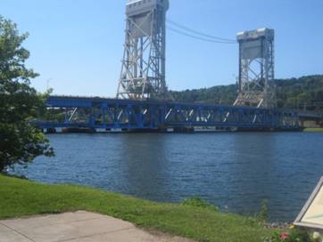 Figure 1. Looking west at the Keweenaw Waterway and the Houghton-Hancock Bridge. Source: A. Sproul
EarthCache Lesson:
What caused this formation to occur here?
The Keweenaw waterway has been affected by all of the geologic processes that occurred in this region in the last 1 billion years. This began in the Precambrian when a hot spot in the mantle of the earth caused a Mid-Continental Rift to form in the middle of North America. This rift system curved up through Lake Superior and then down towards the Detroit area. The activity of the rift caused extensive basaltic lava flows to cover the area that is now the Keweenaw Peninsula. As the activity of the rift eventually slowed and stopped, the area of the Keweenaw would subside under the weight of the large lava flows. This combined with the shifting of tectonic plates of the region would form the large syncline that now exists in the area.
There are numerous faults along the Keweenaw Peninsula and it is thought that a fault can be found here at the waterway. Although not visible at the surface, this fault is thought to run on an east-west course, cutting across the peninsula. The concept of this fault at the waterway helps to explain how the strong basaltic rocks have been weakened here, assisting in the natural formation of the waterway.
Although the rocks could have been weakened and shifted by the action of the fault, there still needed to be erosion to help carve out the waterway. This erosion is thought to have come from the region’s glacial activity. The erosion of the canal would have resulted from it acting as a path for the large outflow of melt water from the receding glaciers. Glacial lake Duluth existed to the west of the area and most likely flooded the Keweenaw waterway many times with high energy waters, deepening the erosion of the canal.
Logging Your Visit:
To obtain credit for visiting this EarthCache, please email me the responses to the following questions:
- Logging Question 1: The rocks in this area tend to dip to the northwest, towards Lake Superior. Is the canal parallel to this orientation, or is it perpendicular?
- Logging Question 2: Do you think there might be copper in the rocks at the bottom of the waterway? Why or why not? Is there anything in your field of view that may give you a clue in answering this question?
- Logging Question 3: Looking towards Hancock (to the north) and behind you towards Houghton, what are some signs of the geologic activity that happened here in the last 1 billion years? Does the look of the landscape support some of the theories on the formation of the waterway? Explain your answer.
Earth Science Literacy Principles Big Ideas:
Big Idea 1: Earth scientists use repeatable observations and testable ideas to understand and explain our planet.
1.6: Earth scientists construct models of Earth and its processes that best explain the available geologic evidence.
There is no fault visible at the surface, nor were we here to witness the glacial melt waters eroding the Keweenaw waterway. We can however utilize models and geologic clues to help form a theory on the formation of this area.
Common Earth Science Misconceptions:
“Science always has exact answers”
The Keweenaw waterway is essentially a geologic mystery. Although there are many well formed theories on its formation, to say that the exact answer has been found is really not quite true.
References:
"Glacial Lakes."
Glacial Lakes. Michigan State University Department of Geography, n.d. Web. 24 July 2012.
http://www.geo.msu.edu/geogmich/glacial.html
"Keweenaw Waterway."
Wikipedia. Wikimedia Foundation, 28 July 2012. Web. 28 July 2012. http://en.wikipedia.org/wiki/Keweenaw_Waterway.
Rose, William. Personal interview. 28 June 2012.
Stinkycheezman33. "A Brief Geological History of the Keweenaw."
: Articles : SummitPost. Summitpost.org, 5 June 2009. Web. 24 July 2012. http://www.summitpost.org/a-brief-geological-history-of-the-keweenaw/518925