Jättegryta kallas en rundad urholkning i berget som har uppkommit genom nötning då starkt strömmande vatten har nött grus och stenar mot berget. Ibland finns en sten, en så kallad löpare, kvar i jättegrytan och denna är då ofta helt klotrund. Det är dock inte ovanligt att dessa stenar har försvunnit under tidens lopp.
Många jättegrytor kan fortfarande vara oupptäckta eftersom de är fyllda med sten och sand. De största jättegrytorna i Norden är 8–10 meter i diameter och 20–30 meter djupa.
Glaciala jättegrytor har bildats under istiden när smältvatten från inlandsisen strömmat fram under kraftigt tryck vid bottnen av isen och satt stenar och annat moränmaterial i rotation. Jättegrytor kan också bildas i forsar, där hög strömhastighet och virvlande vatten orsakar erosion, eller vid havsstränder.
Vid en bergklack eller något annat hinder i älven ökar vattnets strömhastighet och de i vattnet lösta gaserna bildar bubblor. Nedanför bergklacken minskar strömhastigheten tvärt och gasbubblorna upplöses. Om detta sker nära berghällen får man en hammarslagsliknande effekt. Den här processen kallas kavitation och den är effektivast där hällen är svag, som till exempel i sprickor.
Genom kavitation bildas små gropar i berghällen vilka utgör början till jättegrytor. Jättegrytorna bildas sedan genom den slipverkan som sand, grus och stenar utför i det starkt virvlande vattnet.
I äldre tider ansåg man att jättegrytor hade samband med jättar på samma sätt som de stora flyttblocken som kallades ”jättekast”. Man trodde att jättar brukade laga sin mat i hålorna.
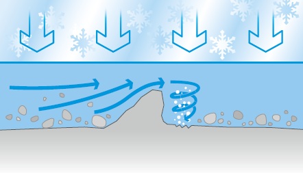
Här börjar en jättegryta bildas. Inlandsisen orsakar ett tryck på smältvattnet som forsar fram under isen.
Here begins the forming of the pothole. The ice sheet causes a pressure of melt water that rushes up the ice.
Bakom ett hinder eller en spricka i berget börjar vattnet virvla och luftbubblorna som bildas gör att berget går sönder bit för bit.
Behind a barrier or a crack in the rock the water starts to swirl and the air bubbles that are formed means that the rock breaks, piece by piece.
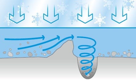
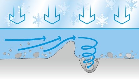
Grus och stenar hjälper till att utvidga och slipa grytan som blir rund och jämn till formen.
Gravel and stones helps to extend and sharpen the pot that is round and smooth in shape.
Här precis vid dikeskanten hittar du två stycken jättegrytor, som bildades här när inladsisen drog sig tillbaka för 12 500 år sedan, och då låg denna plats under "havets"yta. Man räknar med att havet stod 170m över nuvarande strandlinje för 12 500 år sedan.
För att logga denna Earthcachen som hittad skall du FÖRST skicka svaret på följande frågor via mail till cacheägaren(Djurets).
OBS! Inga svar i loggen!
1. Vad heter denna Earthcache?
2. Hur djupa är de båda jättegrytorna i cm?
3. Vad kallas den hammarslags liknande effekt som hjälper till att skapa dessa jättegrytor?
Ladda gärna upp en bild på dig själv och/eller din GPS i loggen från platsen. Det är inget krav men det uppskattas mycket!
[English]
Giant kettles(potholes) called a rounded depression in the rock that has arisen through wear when strong currents have worn pebbles and stones against the rock. Sometimes there is a stone, called runners, remain in the pothole, and this is often quite spherical. However, it is not uncommon for these stones have disappeared over time.
Many potholes may remain undetected because they are filled with stone and sand. The biggest potholes in the Nordic countries is 8-10m in diameter and 20-30 meters deep.
Glacial potholes have formed during the Ice Age, when meltwater from the ice sheet flowed under high pressure at the bottom of the ice and put rocks and moraine material in rotation. Potholes may also form in the rapids, where high velocity and turbulent water causes erosion, or at the seaside.
At a rock outcrop or other obstructions in the river increases the water velocity, and the water dissolved gases forming bubbles. Below the rock heel reduces the flow velocity abruptly, and the gas bubbles dissolve. If this occurs near the rock you get a hammer-like effect. This process is called cavitation, and it is most efficient where the hob is weak, such as in cracks.
The cavitation formation of small pits in the rock which marks the beginning of potholes. Giant pots are then formed by the abrasive action of sand, gravel and stones out of the strongly swirling water.
In olden times it was thought that giant kettles were associated with giants in the same way as the large boulders, called "giant roll". It was believed that giants used to cook their food in the potholes.
To log this Earth cache as found, please FIRST send the answer to these questions by mail to the cache owner (Djurets).
NOTE! No answers in the log!
1. What is the name of this Earth Cache?
2. How deep are the two potholes in cm?
3. What is called the hammer-type-like effect that helps to create those potholes?
Feel free to upload a picture of yourself and / or your GPS in log from the site. It is not required but greatly appreciated!
Here, right at the edge of the ditch you will find two giant kettles, which was established here when the ice retreated 12 500 years ago, at this time lay this location under the "sea" surface. It is estimated that sea level was 170m above the present shoreline for 12 500 years ago.