SIBIU - THE DEFENCE WALLS
The exterior defence wall may be admired in all its splendor along the Coposu Boulevard. The wall is pierced by a semicircular arch which allows the access of the pedestrians.
The wall on Cetatii Street escaped the "systematization" in the 19th century. Nowadays the wall preserved its aspect from the 15th century, when it was rebuilt in bricks and equipped towards the interior with ample arcades which support the guard path.
[EN] The geocache location is: N 45° 47.ABC E 024° 09.DEF
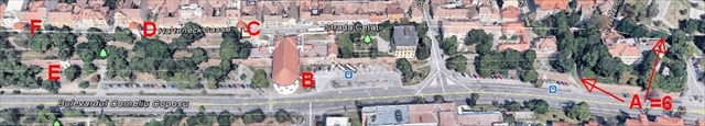
A: The tour of the defence walls begins at Haller Bastion (Hallerbastei) [N 45° 47.738 E 024° 09.421]. The spade shaped building was initiated by the general Castaldo, at the time when Petru Haller was the mayor of Sibiu. The building was finalized in 1553. The bastion is built in brick and filled with earth, its walls having a total length of 223 meters and the maximum height of the wall is of 9 meters. The openings of the pill boxes for the cannons are preserved both towards the Thick Tower and towards Manejului Street.
The first digit of the coordinates: number of pillboxes for cannons + number of tunnels to remove the cannons outside.
B: We continue the visit with the Thick Tower. (Dicker Turm) [N 45° 47.657 E 024° 09.244] It is a massive construction built on a semicircular base, with brick walls (the base being made of stone) and a platform where the canons were once placed. The tower is U-shaped standing out by 25 meters from the exterior wall. It had several defensive levels representing a genuine war machine. The tower was erected by Marcus Pempfflinger. The first theatre in Sibiu functioned in this tower since 1778 (Martin Hochmeister). It was recently rehabilitated entirely and it is now the headquarters of the State Philharmonics in Sibiu.
The second digit of the coordinates: the last digit of the year marked on the board with Sala Thalia.
C: We climb and reach the Carpenters' Tower (Zimmermannsturm), built in XIV century. [N 45° 47.656 E 024° 09.192] It is the northernmost of the towers located on Cetatii (Harteneck) Street. It has a circular plan at the base. From the level of the cornice, the tower has the shape of an polygonal prism concluded in its superior part by a body standing out towards the exterior and sustained by consoles with crude oil holes between arches. The connective wall between these towers is a recent reconstruction of the old wall that once connected them.
The third digit of the coordinates: the difference between number of towers standing on the Cetatii street and number of the fortifications belt (girdle of walls) which they belong (see the info sign).
D: Next point is the Potters' Tower (Töpferturm), built of stone and brick on the XIVth century. [N 45° 47.626 E 024° 09.132] Its superior part, standing out from the main body, is supported by a row of consoles with holes used for launching. Five firing holes for arquebuses are placed all around it.
The fourth digit of the coordinates is given by the difference between the number of sides of Carpenters' Tower and the double number of sides of Potters' Tower.
E: We descend outside the wall and see the bust of Emperor Francis I of Austria, placed in 1828 in a wall niche site of the City of Sibiu, in the middle of the promenade. [N 45° 47.595 E 024° 09.112] Francis I was Holy Roman Emperor, King of Hungary and of Bohemia and Emperor of Austria. He visited the city of Sibiu (Hermannstadt) in a fall in the second decade of the nineteenth century with his wife, Empress Carolina Augusta.
The fifth digit of the coordinates: the last digit of the year in which Francis I visited Sibiu (see the inscription on the marble plaque).
F: We climb back to the Arquebusiers Tower (Armbrusterturm), built in XIV century. [N 45° 47.599 E 024° 09.073] The tower has the shape of an polygonal prism with the superior part standing out from the main body, supported by consoles with arches in which holes for launching are placed. The firing holes at the first level have the shape of a key hole. Up to the height of 1 meter the tower is built in stone and the superior part is made of bricks. It later became the Weavers' Tower, named after the guild which administrated it.
The sixth digit of the coordinates: is equal to the last digit of the year written on the top (wall) of the tower.
The path lenght =1 km.
You can check your answers on GeoChecker.com.
[RO] Geocutia se află la coordonatele N 45° 47.ABC E 024° 09.DEF
A: Turul centurii de fortificaţii începe la Bastionul Haller [N 45° 47.738 E 024° 09.421]. Construcţia în formă de pică a fost iniţiată de generalul austriac Castaldo în timpul primarului Peter Haller şi a fost terminată în 1553. Bastionul este construit din caramidă şi umplut cu pământ, având zidurile cu o lungime totală de 223 metri si înălţimea maximă de 9 metri. Bastionul are o suprafaţă mare, permitând instalarea unui numar mare de tunuri. Au fost realizate cazemate cu deschideri pentru tunuri, atât spre Turnul Gros, cât si spre str. Manejului.
Prima cifră a coordonatelor ascunzişului este numărul deschiderilor cazematelor pentru tunuri + numărul tunelurilor pentru scoaterea tunurilor in exterior.
B: Trecând pe lânga Poarta Leşurilor (deschisă în zid in 1554) continuăm vizita cu Turnul Gros [N 45° 47.657 E 024° 09.244], construit in secolul XVI de Marcus Pemfflinger, judele regal al Sibiului. La nivelul inferior se aflau mai multe cazemate cu guri de tragere. Pe platforma turnului erau amplasate tunuri cu care se trăgea asupra atacatorilor. În anul 1787, tipograful Martin Hochmeister a solicitat şi obţinut cedarea clădirii Turnului Gros pentru a se amenaja acolo un teatru oraşenesc, primul teatru de pe teritoriul actual al României. În perioada 1990-2004, s-a reconstruit sala de spectacole şi începând din mai 2004, aici se află Sala Thalia a Filarmonicii de Stat din Sibiu.
A doua cifră a coordonatelor ascunzişului este ultima cifră din anul marcat pe tabla cu Sala Thalia.
C: Urcăm, trecem printr-o străpungere cu boltă semicirculară şi ajungem la Turnul Dulgherilor, construit în secolul al XIV-lea. [N 45° 47.656 E 024° 09.192] El este cel mai nordic dintre turnurile aflate pe str. Cetatii (Harteneck). Porţiunea zidurilor de fortificaţie dintre turnurile Dulgherilor şi Olarilor a scăpat de sistematizarea din sec. XIX. În prezent zidul are aspectul avut in a doua jumătate a secolului al XV-lea, având deasupra drumul de strajă. Acesta are un parapet din lemn si acoperiş sustinut de stâlpi din lemn.
A treia cifră a coordonatelor ascunzişului este diferenţa dintre numărul turnurilor rămase în picioare pe strada Cetăţii şi numărul centurii de fortificaţii din care ele fac parte.
D: Următorul obiectiv este Turnul Olarilor, construit din piatră şi căramidă în secolul al XIV-lea. [N 45° 47.626 E 024° 09.132] La primul si al doilea nivel se află metereze în formă de gaura de cheie, realizate în special pentru a permite executarea focului de archebuze.
A patra cifră a coordonatelor ascunzişului este dată de diferenţa dintre numărul laturilor Turnului Dulgherilor şi dublul numărului laturilor Turnului Olarilor.
E: Coborâm în exteriorul zidului şi vedem bustul împăratului Francisc I al Austriei, amplasat în anul 1828 într-o nişă a zidului de incintă a Cetăţii Sibiului, la mijlocul promenadei ce se întindea de la fostul Bastion al Cisnadiei la Turnul Gros. [N 45° 47.595 E 024° 09.112] Francisc I a fost împărat al Sfântului Imperiu Roman, rege al Ungariei şi al Boemiei şi împărat al Austriei. El a vizitat oraşul Sibiu într-o toamnă din a doua decadă a secolului XIX împreună cu soţia sa, împărăteasa Carolina Augusta, cu acel prilej fiind realizat iluminatul stradal al orasului.
A cincea cifră a coordonatelor ascunzişului este dată de ultima cifra a anului in care Francisc I a vizitat Sibiul (a se vedea inscripţia de pe placa de marmură de sub bust).
F: Urcăm înapoi la Turnul Archebuzierilor, construit în secolul al XIV-lea. [N 45° 47.599 E 024° 09.073] Denumirea sa provine de la prezenţa la primul nivel a unor metereze în formă de gaură de cheie, prin care se putea trage cu archebuza. Ulterior, a fost denumit Turnul Postăvarilor sau al Pânzarilor.
A şasea cifră a coordonatelor ascunzişului este egală cu ultima cifră din anul înscris sus pe turn.
Lungimea traseului = 1 km.
[HU] A geodoboz koordinátái: N 45° 47.ABC E 024° 09.DEF
Nagyszeben városát a XIV. és XVI. század között épült erős várfalak, többszörös védelmi gyűrű és több mint 40 bástya és torony védte. Ez a rejtés a várfalak egy részét bemutató 6 lépéses rejtekhely. A geodoboz koordinátáihoz végig kell járni a leírt helyszíneket.
A: A Felsőváros déli szélén épen maradt erődítmények túráját a Haller-bástyánál kezdjük. [N 45° 47.738 E 024° 09.421]. Castaldo osztrák tábornok kezdeményezésére Petrus Haller városbíró épittette 1551-1553 között. A bástya téglából épült és földel van feltöltve. A falak teljes hossza 223 méter, a maximális magassága 9 méter. 1771-ben ráépült a lovarda (manege), majd a XX. század első évtizedében a jelenlegi épület - ma kórház. A nagy felületű bástyában számos lövegállást helyeztek el, melyeknek nyílásai délnyugatra (Coposu út) és északkeletre (P. Onofreiu utca) néznek. A rejtekhely koordinátáinak első számjegye:
A = az ágyúk számára létesített nyílások száma + az ágyuk kihozatalára való kapuk száma.
B: A bástyától délnyugatra áll, az alakja után Vastag (kövér) Toronynak nevezett, rondella, [N 45° 47.657 E 024° 09.244] melyet Marcus Pemfflinger királybíró épittetett 1540-ben. Ezt a erőditményt is több várágyú védte. Ebben hozta létre 1787-ben Martin Hochmeister nyomdász az első német ajkú színházat. A színház egy év alatt épült fel és 1788 júniusában megtartották az első előadást. 1990-2004 között az egészet átépítették, és ma a Nagyszebeni Állami Filharmónia otthona.
A második számjegy: B = a Thália termet jelző táblán levő évszám utolsó számjegye.
C: Továbbmegyünk és áthaladunk a külső várfalon, fel az Ácsok toronyához (Kádár-torony). [N 45° 47.656 E 024° 09.192]. Ez az első a Vár (Harteneck, Cetatii) utcán megmaradt XIV. századi tornyok közül. Az első két torony között, alsó szintjén árkádos, felette fából épült fedett folyosós, várfal húzódik. Az Ácsok tornya kör alaprajzról indul, feljebb sokszögűre vált, majd a legfelső, kulcslyuk formájú lőrésekkel is ellátott, szakaszán kiszélesedik.
A harmadik számjegy: C = a belső védelmi gyűrű (Cetatii utca) megmaradt tornyainak száma és a védelmi gyűrű száma (lásd a táblát) közötti különbség.
D: A következő célpont a Fazekasok tornya, mely kőből és téglából épült a XIV. században. [N 45° 47.626 E 024° 09.132]. A felső szinteken a falakon kulcslyuk alakú, kifejezetten a szakállas puskáknak kialakított lőrések találhatóak.
A negyedik számjegy: D = az Ácsok tornya (felsőrészének) oldalainak száma és a Fazekasok tornya oldalainak duplája közötti különbség.
E: Lemegyünk a lépcsőkön a külső fal alá és egy szökőkút mellett meglátjuk Ferenc magyar király (II.Ferenc néven német-római császár és cseh király, majd I. Ferenc néven osztrák császár) mellszobrát. [N 45° 47.595 E 024° 09.112]. A szobrot 1828-ban helyezték a várfal alatti sétány közepén egy, a falban létesített, fülkében. Ferenc király a XIX. század második évtízedében feleségével, Carolina Augustával együtt, meglátogatta Nagyszebent.
Az ötödik számjegy: E = annak az évnek az utolsó számjegye amelyben a király itt járt Nagyszebenben (lásd a felíratatot a szobor alatti márványtáblán).
F: Visszamegyünk a falakon belülre a Fegyverkovácsok tornyához. [N 45° 47.599 E 024° 09.703]. A torony egy kő alapzatú, téglából készült erőditmény. A nyolcszögű torony felső részén, mely szélesebb a lenti résznél, öntőlyukak sorakoznak. Feljebb itt is kulcslyuk alakú nyílásokat láthatunk melyeket tűzfegyverek használatára képezték ki. Ezt a tornyot később Takács-toronynak is nevezték.
A hatodik számjegy: F = a fent a tornyon levő évszám utolsó számjegye (éjszaka nem nagyon látszik).
Az útvonal hossza =1 km.