[FIN] Orinoron rotkolaakso on yksi suosituimpia geologisia nähtävyyksiä koko Itä-Suomessa. Orinoro sijaitsee Suomen suurimmassa saaressa Soisalossa, Leppävirran kunnan Mustinmäen kylässä. Nimensä Orinoro on perimätiedon mukaan saanut siitä että sinne olisi muinoin tipahtanut orihevonen tai parikin.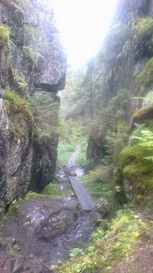
Geologisesti Orinoro on miljoonia vuosia sitten tapahtuneen maanjäristyksen aiheuttama maanrepeämä eli ruhje. Viimeisen jääkauden aikana eli Veiksel-jääkauden aikana 11500 vuotta sitten jäätikköjoen vesi virtasi jäätikön pohjalla usein paineenalaisena ja siksipä sillä oli valtavat voimat. Orinoron tyyppisessä ruhjelaaksossa se on erityisen hyvin näkyvillä. Tänäkin päivänä voit nähdä siellä kuinka valtavien jäämassojen alla kulkenut vesi on huuhtonut ja hionut maanjäristyksen jäljiltä ruhjeen pohjalta ja kallioperästä kaiken maa-aineksen mennessään ja jättänyt paikoitellen ”patomaisia” kasautumia uoman pohjalle. Tämä on yksi syy rotkon pohjan kumpuilevaisuuteen, eli syvyysvaihteluun. Solan kallioseinämistä voi hyvin nähdä edelleen sen kuinka rotkon päältä vyöryneet jäämassat ovat liuskottaneet alueen kallioperää pystysuuntaisesti. Viime jääkausi siis muovasi tämän maanjäristyksen aiheuttaman kallioperän ruhjeen sellaiseksi kuin se nyt on. Viime jääkausi eli Veiksel-jääkausi päättyi noin 11 500 vuotta sitten alkaneeseen lämpökauteen, jota elämme yhä tälläkin hetkellä.
GPS-laite toimii heikosti rotkon pohjalla mutta ylös rotkon päälle ei tarvitse mennä missään vaiheessa vaan annettu tehtävien arviointi / suorituspaikka sijaitsee rotkon pohjalla olevan matalan kumpareen reunalla, niin että maisema on alla olevan kuvan mukainen. Antakaa palautetta miten annetut koordinaatit natsasivat paikkaan..

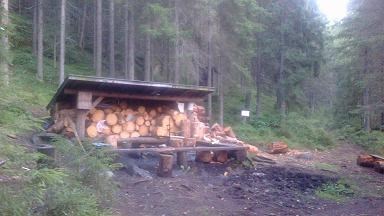
Rotkosolaa lähimmän parkkipaikan löydät alla olevasta reittipisteestä, samoin kuin myös rotkon lähistöllä olevan nuotiopaikan, joka alla kuvassa.
TEHTÄVÄT NOLLAPISTEESSÄ:
1. Arvioi solan syvyys, leveys ja pituus annetuissa naateissa.
2. Jos Yoldian jäämeren aikaan alue oli merenpinnan tasolla, mikä on sijaintisi korkeus nyt nykyisestä merenpinnasta annetuissa naateissa??
3. Mitä eroa havaitset toisenpuolen kallioseinämän pinnassa verrattuna toisen puolen seinämän pintaan annetuissa naateissa?
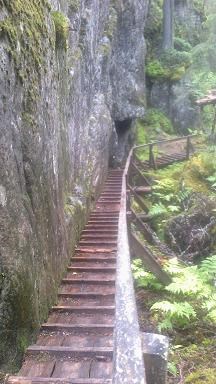
4. Vapaaehtoistehtävänä mikäli otit kameran mukaan, voit halutessasi liittää sähköpostiin tai loggaukseen kuvan itsestäsi ja gepsistäsi annetuissa koordinaateissa niin että sola pitkospuineen näkyy taustallasi.
5. Lähetä tehtävien vastaukset sähköpostilla kätkön omistajalle. Tämän jälkeen voit tehdä löytöloggauksen. Mikäli vastaukset ovat täysin väärin tai jos vastauksia ei ole lainkaan lähetetty kätkön omistajalle ennen loggausta, niin kätkön omistaja poistaa löytöloggauksen. Mikäli vastauksissa on vain pientä huomautettavaa, niin saat kommentit kätkön omistajalta. 
Elämysrikasta geologian tutkimusretkeä Orinorolle! 

[ENG] Gorge Valley of Orinoro is one of the most famous geological seightseeings in hole Eastern-Finland. Orinoro locals in Soisalo, which is the biggest island of Finland, in municipality of Leppävirta and in Mustinmäki village. Province is Pohjois-Savo.Orinoro has get it's name with tradition from that there had dropped down stallion-horse or two in history. So the name Orinoro means stallion-trickle in english. It is third uppermost gorge valley in Eastern-Finland after Kolvananuuro and Seinävuori gorge valley!
Geologically, Orinoro is a rupture, which was caused by an aerthquake millions of years ago. At last ice age, Vistula-ice age over 11 000 years ago Glacier river´s water flowed usually under pressure under glacier and that's why it had massive forces. In Orinoro canyon it is still seen very good. Still at nowadays you can see there how flowed water under great glacier-masses has washed out and cleaned from earthquake's tracks every soil from the bottom of this rift and from the local bedrock and left soil in places ”barrages-like” stratums to the bottom of the channel. This is one of the reasons for bottom´s woldness alias depth variation. From the cliffs of this canyon you can see still also good how from the topside of rift glacier masses has torrented down and divided into lobes area's bedrock vertically. So the last ice age shaped this earthquake's generated solid rock rift the way it is like available on nowadays! The last ice age alias Vistula-ice age in Scandinavia finished about 11 500 years ago when here started that holocene, what we still are living for and what has made those plants what is growing on this high and narrow canyon-zone.
GPS may not work well on the bottom of the gorge, but anyway, you can do your tasks on the bottom of the gorge so that the landscape is exactly like in the picture below of this chapter. Please, give me opinions how given coordinates worked out in zero-point...
The nearest parking-area from gorge canyon you can see from the below beeing waypoints, like also nearby of gorge situated lean-to with campfire place, what is in the picture below.
TASKS IN ZERO-POINT:
1. Estimate the length, depth and width of the gorge at the given coordinates.
2. If at the times of Yoldian ice sea this area has been at sea level, what is height of your locallity right now from current sea level at given coordinates?
3. Explain what differents do you recognize from another side's rock face afloat compared to opposite rock face texture at the given coordinates?
4. Volynteer task: If you took your camera to this geological trip with you, please take a picture from you and your GPS at task-place in given coordinates the way that gorge valley and causeway shows on your background and add them to your log or send it to cache owner's e-mail with your answers to given tasks.
5. Send your answers to tasks by e-mail to the cache's owner. After sending your answers, you can make "Found it" logging. If the answers are totally wrong, or if you don't sent your answers at all, the cache's owner will delete your log.
Expierience-rich geological expedition to Orinoro ”Grand Canyon”!