The Ruins of Obrovac Traditional Cache
-
Difficulty:
-

-
Terrain:
-

Size:  (micro)
Please note Use of geocaching.com services is subject to the terms and conditions
in our disclaimer.
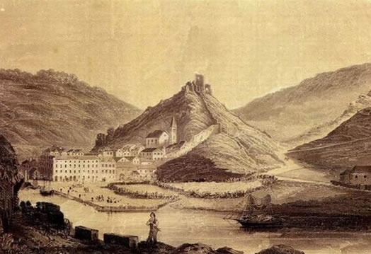
Obrovac is a town and port on the left bank of the Zrmanja river, 11 km upstream of its estuary in the Novigrad Sea. Obrovac is situated at an extension of the limestone canyon, at the place where the way toward Zadar crosses the Zrmanja. Very impressive is the Zrmanja canyon, from Obrovac to the Zrmanja estuary, with extremely steep river banks, at some places even up to 200 m high.
Obrovac was the original location of an important Roman settlement, Clambetae (today the hill-fort Cvijina Gradina, about 3 km southwest of Obrovac). A part of the urban unit of an ancient settlement, with the remains of town streets and structures, has been found here.
Obrovac was first mentioned in the sources of Croatian rulers under the name Obrovez. Until 1527 it was part of the estates of the counts of Krbava; upon that it fell under the Turkish rule; in 1684 it was taken by Venice.
Above the town are the ruins of a fortified town, extended and fortified by the dukes of Krbava, then by the Turks and the Venetians. The parish church below the hill-fort was erected after the withdrawal of the Turks; it was restored in the 18th century.
Have fun searching the cache and enjoy the beautiful view from this point over Obrovac. Pictures are highly appreciated.
Additional Hints
(Decrypt)
Tb gb gur bhgfvqr bs gur ovt jnyy gb gur fbhgu rnfg pbeare. Frr fcbvyre cvpgher.