GEOLOGY:
During the last glacial period, the Würm glaciation, the island of Als was completely covered by ice, more that 100 meters thick. The Würm glaciation began 115.000 years ago end ended about 11.700 years ago. When the glaciers moved back to the north, the coastal cliffs were shaped.
The so-called boulder-clay of a cliff is not very stable. Erosional processes attack a cliff, it is undercut by waves, pressed by groundwater, eroded by the weather or caved by animals (at Saruphav clint you may watch birds living in cliff caves high above during breeding season; please do not disturb them!).
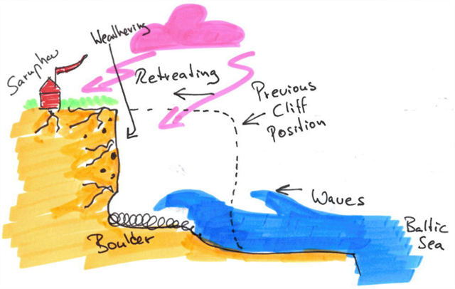 Cliff erosion
Source: own illustration
Depending on the profile of a cliff, the erosion processes can be faster or slower. At the Little Belt we have two main profiles: the exposed coast and the moderately exposed coast.
Cliff on exposed coast:
Very near to the breaker zone of waves.
Big boulder stones, often flooded by the sea.
Small beach area, less sand, mainly gravel.
Cliff on moderately exposed coast:
Not directly at the breaker zone of waves.
Broader beach area, more sand, smaller boulder.
Different plants at the top of the cliff.
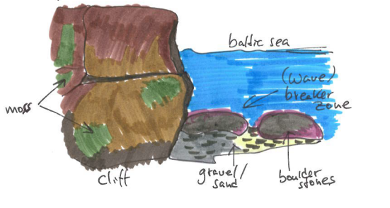
Cliff on exposed coast
Source: own illustration
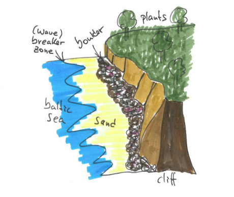
Cliff on moderately exposed coast
Source: own illustration
Parts of a cliff can collapse, that’s what we call an active cliff. The opposite is called a passive or dead cliff. Sometimes it is difficult to distinguish, so there are some indications.
What are the main indications of an active cliff?
An active cliff is dynamic , there are fresh breakups and landslides.
Little vegation, only specific plants, e.g. moss (pottia bryoides).
Boulder stones are still covered with sand and silt, coming directly out of the breakups.
What are the main indications of a passive cliff?
No fresh breakups.
Broad vegetation coverage. Older plants.
Boulder stones shows signs of weathering, because they have been there for a longer period.
Let us look into the details of an active cliff
The geological material of Saruphav cliff is a mixture of sand, silt and boulder (at this location mainly including red granite, limestone and flint). The boulder stones were left by the glaciers. Over time the stones, especially the sedimentary rock like sandstones, were worn into silt-like grain. In contrast igneous rock like granites could not be worn, because they are much harder. They are contained completely in the boulder clay.
Sapruphav cliff is famous for its fine silt, but the high percentage of silt in the boulder clay increases the instability of this cliff. This silt becomes viscous, when it gets wet. Watch out for the silt, you may find and touch it best at the foot of the cliff where some water leaks. If you visit the cliff in dry weather, don’t forget to carry a small container with you to wet the silt for exploration!
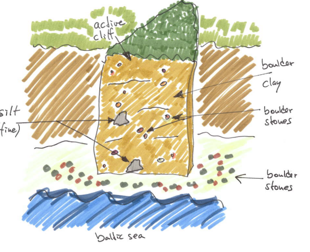
Boulder clay
Source: own illustration
GEOLOGI:
I løbet af den sidste istid (Wurm istiden) Als var helt dækket af is, mere end 100 meter tyk. Den Wurm Istiden begyndte for 115.000 år siden afslutningen endte omkring 11.700 år siden. Når gletscherne flyttet tilbage nordpå, de var kystklinter formede.
En klint er ikke særlig stabilt. Erosion processer angribe en klint, er det underbudt af bølger, presset af grundvand, eroderet af vejret eller udhulet af dyr (på Saruphav klint kan du se fugle, der lever i klippe huler højt over i yngletiden; vær venlig ikke at forstyrre dem!). Se også billedet "Cliff erosion".
Afhængigt af kystnære profilen, erosion på klinten kan være hurtigere eller langsommere. Ved Lillebælt der er hovedsageligt to profiler: en eksponeret kyst og en moderat eksponeret kyst. Se også billedet "Cliff on exposed coast" og "Cliff on moderately exposed coast".
Kliff en eksponeret kyst:
Meget tæt på zone brydende bølger.
Store sten, ofte oversvømmede af bølgerne.
Lille strand, mindre sand, hovedsageligt grus.
Kliff en moderat eksponeret kyst:
Ikke direkte på zone brydende bølger.
Bredere strand område, mere sand, mindre sten.
Forskellige planter i toppen af klinten.
Dele af en klint kan kollapse, det er hvad vi kalder en aktiv klint. Det modsatte kaldes en passiv eller døde klint. Undertiden er det vanskeligt at skelne, så der er visse indikationer.
Hvad er de vigtigste tegn på en aktiv klint?
En aktiv klint er dynamisk, der er friske jordskred.
Lille vegation, kun bestemte planter, f.eks mos (pottia bryoides).
Sten er dækket med sand og dynd, der kommer direkte ud af jordskred.
Hvad er de vigtigste tegn på en passiv klint?
Ingen friske jordskred.
Mere vegetation. Ældre planter.
Stone viser tegn på forvitring, fordi de har været der i en længere periode.
Lad os se i detaljer med en aktiv klint
Det geologisk materiale af Saruphav klint er en blanding af sand, silt og rock (primært herunder rød granit, kalk og flint). Stenene blev efterladt af gletschere. Over tid stenene blev båret ind i kornet, især sedimentære (eksempelvis sandsten). I magmatiske (eksempelvis granitten) ikke kunne bæres, fordi de er meget sværere. De er indeholdt fuldstændigt i klinten.
Jorden her på Saruphav indeholder lag af meget finkornet ler, der bliver tyktflydende, når det bliver vådt. Dette gør klinten ustabil. Pas på finkornet ler, kan du finde og røre ved det bedst ved foden af klippen. Hvis du besøger klinten, når det er tørt, medbring en lille container at befugte den med vand. Se også billedet "Boulder clay".
TASKS:
To log this earthcache please answer the following questions by mail to the cache ower. You can log immediately after sending the mail, we will contact you in case of questions.
1) Which coastal profile can you see between waypoint 1 and waypoint 2? Is this cliff on an exposed coast or on a moderately exposed coast? Please explain why you think so.
2) Describe the actual condition of the active cliff at waypoint 2. Which indications of an active cliff can you see here? (For example: are there new breakups? can you see and touch fresh silt? what about plants and boulder stones?)
OPGAVER:
For at logge denne earthcache bedes besvare følgende spørgsmål. Send venligst en mail til owner. Du kan logge umiddelbart efter afsendelse af e-mail. Vi vil kontakte dig i tilfælde af ethvert spørgsmål.
1) Hvad kystnære profil kan du se mellem WP1 og WP2? Er dette kliff en eksponeret kyst eller moderat eksponeret kyst? Forklar venligst hvorfor du mener det.
2) Beskriv den aktuelle tilstand af det aktive klinten ved waypoint 2. Hvilke tegn på en aktiv klinten kan du se her? (For eksempel: er der nye jordskred? kan du se og røre friske ler? kan du se planter og sten?)
FOR TOURISTS:
Starting at waypoint 2 there is also the opportunity to swim in the baltic sea or to go fishing. If you are interested in a little hiking tour you may also park your car at Mommark harbour and follow the hiking signs of Alsstien along the coast (you will reach waypoint 2 before waypoint 1). Please find more information about this part of the Alsstien in the official handout (danish only).