 Stromatolites at Horseshoe Harbor
Cache Summary: At the tip of the Keweenaw Peninsula, Horseshoe Harbor features excellent examples of ancient stromatolites within the dipping layers of Copper Harbor Conglomerate rock. These unique geologic features provide a glimpse 1.1 billion years into the Earth’s history when cyanobacteria such as these ruled the world. By exploring this EarthCache visitors will make geologic observations and predictions of the past conditions.
Horseshoe Harbor is part of the Mary Macdonald Preserve and managed by the Nature Conservancy. Visitors will traverse a two track road to the parking area, proceeding on foot through a short forested trail and emerging at Horseshoe Harbor’s pebble beach (figure 1) on the shore of Lake Superior. From there visitors will navigate along an outcrop of Copper Harbor Conglomerate to locate this EarthCache.
Cache Coordinates: N 47o28.399’ W 87o48.302’
Begin by traveling east from Copper Harbor on highway 41 until you reach a dirt road (N 47o 27.757’ W87o49.359’), turning North onto the two track road. Navigate to the trailhead at (N 47o 28.153’ W 87o48.224’) and leave your vehicle. Proceed on foot to the pebble beach (N 47o 28.383’ W87o48.074’), remember to stay on established trails. Follow the trail near the edge of the forest to the cache.
EarthCache Lesson:
What does the presence of stromatolites tell us about past conditions in this region?
History of the Keweenaw region
Lake Superior’s very deep basin began forming during the middle Precambrian around 1100 million years ago when a hot spot in the mantel below caused a Mid-Continent rift to form in the middle of the North American continent stretching more than 2,000 km from Eastern Kansas, arching through the Lake Superior region and extending southeasterly to Detroit.
The crust in this area was stretched, thinned and broken allowing molten rock to find its way to the surface through fissures and faults. When these basaltic lava flows cooled they created deposits more than 25 km thick in the center and 5km thick around the edges.
Like most volcanic systems in the world, the rift experienced quieter periods with fewer eruptions when erosion dominated over rock building. Eroded sediments washed down from the edges of the rift by streams and were deposited on top of the basalt. Layer by layer these sediments accumulated, with time and pressure these sediments hardened into what is known today as the Copper Harbor Conglomerate.
A dip in the layered volcanic rocks occurred gradually as a result of sagging from the immense weight of the accumulating volcanic and sedimentary rocks during the rifting event (see figure 2). Later these rocks were uplifted and eventually exposed by glaciers.
Cache: N 47o28.399’ W 87o48.302’
Locate the white-banded outcrop along the ground and within the lower section of the Copper Harbor Conglomerate layers (figure 3), these are one of the many exposures of stromatolites found around the edges of Lake Superior.
These stromatolites are fossil remains of prehistoric cyanobacteria and other microbes (formally called blue-green algae) that formed great colonies, or mats, during the depositional period of the Copper Harbor Conglomerate. Using clues from microbial mat formation happening today (figure 4) it is believed that these ancient colonies began when the bacterial cells produced mucus which trapped debris and carbonate or silica from the surrounding environment thus capturing traces of the environment from the time of their formation. Overtime the cyanobacteria mat became cemented together into a layer with this sediment. Eventually new layers formed above the old creating the banded pattern which is commonly seen in stromatolites.
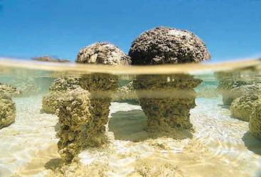 Figure 4. The stromatolites forming today in the shallow waters of Shark Bay, Australia are built by colonies of microbes. Source: University of Wisconsin-Madison
These stromatolites also offer another clue to the past environment in which they were formed. Cyanobacteria are aquatic, living in both fresh water and marine ecosystems. They are also photosynthetic, capturing sunlight to produce their own food. Therefore stromatolites require shallow waters to grow where sunlight can reach the bottom.
Cyanobacteria colonies like these were some of the first life to produce oxygen through photosynthesis. It is widely believed that early life forms like these produced enough oxygen overtime to gradually increase the overall levels of the early Earth’s atmosphere, making life on land possible for more complex life forms. Large microbial mats are rare today, as they are food to many kinds of animals. But 1.1 billion years ago when there were no animals, microbial mats were everywhere and fossilized stromatolites are abundant throughout the rock record.
_______________________________________________________________________________________________________________________
Logging Your Visit:
To obtain credit for visiting this EarthCache, please email me the responses to the following question:
-
Logging Question 1: Based on what you have learned about stromatolites. What does the presence of stromatolites tell us about the conditions of this area 1.1 billion years ago?
-
Logging Question 2: How have the environmental conditions of this area changed since these stromatolites thrived here? How are the conditions the same?
- Logging Question 3: Make detailed observations of these white-banded stromatolites. Describe their shape, color, thickness, etc. How do they compare in shape and size to other rock layers that surround them?
- Bonus Question: Can you find stromatolite in another location? Take a waypoint and send your coordinates.
_______________________________________________________________________________________________________________________
Earth Science Literacy Principles Big Ideas:
Big Idea 2: Earth is 4.6 billion years old
2.1 Earth’s rocks and other materials provide a record of its history. Earth scientists use the structure, sequence, and properties of rocks, sediments, and fossils to reconstruct events in Earth’s history. Understanding geologic processes active in the modern world is crucial to interpreting Earth’s past.
Common Earth Science Misconceptions:
“Earth has always been the way it is now.”
In this EarthCache visitors will observe geologic features at Horseshoe Harbor leading them to understand that the depositional environment 1.1 billion years ago is very different than what it is today. The stromatolites and the Copper Harbor Conglomerate would not have formed under present day conditions. Therefore this challenges the common misconception that the “Earth has always been the way it is now.”
______________________________________________________________________________________________________________________
References:
Eshbach, Charles. (2008).
Horseshoe Harbor: Fossils Tell the Story . Available: http://www.kewtrav.com/index.php?option=com_content&view=article&id=50:three-day-hikes&catid=2:activities&Itemid=13. Last accessed 26th Aug 2011.
http://www.geo.mtu.edu/~raman/SilverI/MiTEP_ESI-2
Mineralogical Society of America. (2011).
Keweenaw Michigan Field Trip. Available: http://www.minsocam.org/msa/collectors_corner/vft/mi2b.htm. Last accessed 26th Aug 2011.
Schaetzl, Randall J ,, Joe T. Darden, and Danita S. Brandt.
Michigan Geography and Geology. New York: Custom, 2009. Print.
Robinson, S. (2001). Is this an agate?: An illustrated guide to Lake Superior's beach stones Michigan. Hancock, Mich: Book Concern Printers.
Rose, Bill. (2011).
Earth Science Institute. Available: http://www.geo.mtu.edu/~raman/SilverI/MiTEP_ESI-2. Last accessed 26th Aug 2011