Aerial Intelligence - Dubuque Mystery Cache
geo-jenkins: Container keeps disappearing.
Aerial Intelligence - Dubuque
-
Difficulty:
-

-
Terrain:
-

Size:  (regular)
Please note Use of geocaching.com services is subject to the terms and conditions
in our disclaimer.
This cache is not located at the above coordinates!
This cache was inspired by Aerial Intelligence - Research Triangle (GCK1FA) by jklGoDuke & lovelace, which was itself inspired by Aerial Intelligence II - The Suburbs (GCHV7V) by kevmikwa which was itself inspired by Aerial Intelligence (GCGPYX) by ic_nevadamike. It is located somewhere in the Dubuque area, but not at the above coordinates, which would put you right at the intersection of the borders of Iowa, Wisconsin, and Illinois. I strongly suggest that you not look for a cache there!
Below is an aerial photograph taken from 1930. The picture has not been rotated - north is up. In the center of the picture is a building that is in the shape of tilted "H" or "I". On the side of the building closest to the circle, facing the circle, there is a statue. The statue is exactly 2.1 miles from the coordinates given above. Your goal is to find this building.
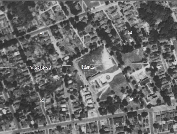
Once you find the building with the statue, take a good look around. There is a brand new building being built just to the south of the building with the statue. It is accessible from the same parking lot. On that building is 4 lines of letters and numbers.
The first line is:
LL#### LLLL (Where L is a letter and # is a number.)
The bottom line is:
###.# LLL LLLLL (Where L is a letter and # is a number.)
A = The 2nd character on the bottom line
B = The 2nd character on the third line minus the 1st character on the bottom line
C = The 3rd character on the top line.
You can convert letters into numbers so that A=1, B=2, etc. Do this to figure out the following:
D = ___ The 2nd letter of the top line minus the last letter of the 3rd line.
E = ___ The last letter of the bottom line minus the 4th to last letter of the 3rd line
F = ___ The 4th to last letter of the bottom line
The actual cache coordinates are N 42° 30.ABC' x W 090° 40.DEF
Fill them in here: N 42° 30.____ x W 090° 40._____
Please do not post any pictures, measurements or descriptions that would give away the actual location of the cache!
Now go find the cache! A few words about it - The cache is a standard ammo box. There are limited number of places to freely park nearby. Try your best to be discrete when finding and re-hiding the cache.
Interpreting Aerial Photographs
Interpreting Aerial Photographs requires some skill, and people take years to become truly proficient at it. Some things to look for include roadways (look for number of lanes, width of road, and turns in the road), buildings (pay attention to size, shape, location), waterways, and other features. Your best bet is probably to have a map in one hand and the aerial photo in the other and switch back and forth between the two comparing features.
You can check your answers for this puzzle on Geochecker.com.
Additional Hints
(Decrypt)
Nrevny Cubgb - Gbjafuvc, Enatr, Frpgvba