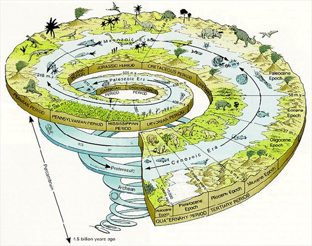
Nos principais maciços calcários portugueses, o processo cársico que conduziu à elaboração de formas e paisagens sui generis, hoje consideradas de elevado valor patrimonial, é um processo longo e complexo em que o Quaternário apenas representa uma porção muito reduzida do tempo total envolvido.
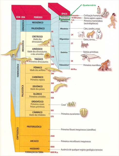
Pensando apenas nos principais maciços calcários da Orla Mesocenozóica ocidental portuguesa, se excetuarmos os tufos calcários (e particularmente o maior afloramento, o dos Tufos de Condeixa) que se terão formado já francamente no Quaternário, sendo portanto muito recentes as formas cársicas (lapiás, dolinas, pequenas lapas e abrigos sob rocha) que neles se desenvolvem, nas restantes rochas calcárias o processo cársico ter-se-á iniciado ainda no Jurássico, sendo marcado por fases de diferente intensidade ao sabor das vicissitudes tectónicas e, sobretudo, dos sucessivos ambientes bioclimáticos registados na região. Tanto em grande parte do Maciço Calcário Estremenho, como no conjunto do Maciço de Sicó, ao Quaternário parece ter ficado reservado, essencialmente, o papel de exumação de paleoformas, algumas pré-cretácicas outras porventura terciárias, ao mesmo tempo que se processava um retoque cársico nas superfícies calcárias entretanto descobertas.
Apesar disso, as formas mais espetaculares, aquelas que detêm um inegável valor patrimonial e que frequentemente correspondem à imagem mais conhecida destes maciços têm a marca indelével dos processos fluviocársicos e cársicos desenvolvidos já no Quaternário.
Na sequência do surguimento dos maciços e na dependência de coberturas gresosas progressivamente remobilizadas desde os tempos cretácicos, que no início do Quaternário teriam ainda, se não um carácter contínuo, pelo menos uma extensão e espessura bem maiores que os poucos restos que hoje se detetam, ter-se-ão criado condições para desenvolvimento das redes fluviais responsáveis por espetaculares canhões, como no caso de Sicó, os canhões dos Poios, do Vale das Buracas e do Vale das Buracas e do Vale da Grota. Outros pequenos canhões, porventura mais dignos do nome, dada a quase absoluta verticalidade das vertentes, como é o caso do canhão do Rio dos Mouros que terá sido uma das razões de ser da instalação da cidade romana de Conímbriga, apesar de, porventura, mais recentes, têm nas mesmas razões as causas da sua génese.
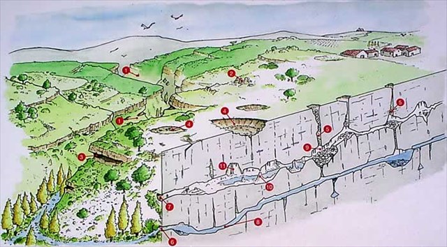
1. Canhão
2. Relevo tipo “ruína”
3. Abrigo Rochoso
4. Dolina
5. Cova
6. Emersão
7. Emersão Fossilizada
8.Galeria
9. Estalactite
10. EStalagmite
11. Coluna
Parte significativa do interesse paisagístico destes canhões fluviocársicos advém do modelado das suas vertentes e designadamente das «buracas», formas do carso superficial que parecem ligar-se a processos de gelifração e de dissolução sob a ação de climas frios. Curtos sectores quase verticais (as «penas»), abrigos sob rocha (as «buracas») e escombreiras de diferentes origens são, sem sombra de dúvidas, marcas quaternárias nas vertentes dos canhões fluviocársicos e noutras vertentes escarpadas que em muito contribuem para a valorização da paisagem.
O mesmo acontece com dois outros tipos de formas, autênticos ex-libris do modelado cársico: os lapiás, responsáveis pelo «deserto de pedras» com que se identifica o carso clássico, e as grutas (lapas e algares) que valem, por si só, pelas belezas que encerram, pelos desafios que proporcionam, e também, sobretudo, pelo que significam no processo e circulação e armazenamento da água. Neste caso foi também já no Quaternário que se desenvolveram os processos responsáveis, pela escultura integral de muitas das formas lapiares ou pelos retoques nelas verificados, assim como foi este o tempo que permitiu as últimas estruturações da rede de galerias que balizam o funcionamento hidrológico do carso atual.
Neste artigo discute-se a importância dos processos verificados durante o Quaternário na construção da paisagem cársica, com particular incidência nas formas que pelas suas especificidade genética, espetacularidade e singularidade mais representam em termos de património ambiental
Fonte: Estudos do Quaternário - Revista da Associação Portuguesa para o Estudo do Quaternário
http://apeq.no.sapo.pt/eq_resumos_3.html
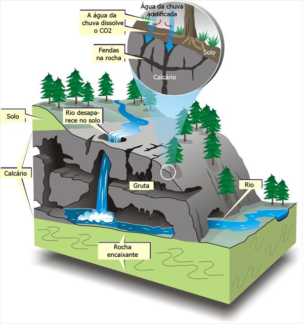
É uma garganta profunda e estreita, ou seja, um desfiladeiro, que se encontra numa zona cársica. Estes mantêm a sua forma devido à relativa imunidade cársica das vertentes calcárias, uma vez que estes têm pouco escoamento superficial.
Existem dois tipos de canhões, no que respeita à sua formação:
- canhões de abatimento (que se formam após o abatimento de abóbadas subterrâneas);
- e de encaixe epigénico dos cursos de água sobre os calcários a favor de coberturas detríticas relativamente impermeáveis (sobretudo os que têm origem fora do maciço calcário).
Por vezes há formação de buracas nas suas vertentes.
Fonte: http://pt.wikipedia.org/wiki/Canh%C3%A3o_fluvio-c%C3%A1rsico
|
|
In the main Portuguese calcareous massifs, the karstic process, which led to the formation of unique landforms and landscapes, nowadays considered of high heritage value, was a long and complex process in which the Quaternary represents only a very small part of the time involved..
Considering only the calcareous massifs of the western Portuguese Mesocenozoic Border, if we except the calcareous tufas (and especially the largest outcrop, the Tufas of Condeixa) which were formed well into the Quaternary, the karstic forms (Karren, dolines, small caves) that developed there therefore being very recent, in the remaining calcareous rocks the karstic process began in the Jurassic period, and was marked by phases of different intensity at the mercy of tectonic changes, and especially of the successive bioclimatic environments registered in the region. Both in the Calcareous Massif of Extremedura and in the Sicó Massif the Quaternary seems to have been essentially the setting for the exhumation of paleoforms, some pre-cretaceous, others perhaps tertiary, at the same time as a karstic retouching of the calcareous surfaces thus uncovered was taking place.
In spite of this, the most spectacular landforms, those which have an incontestable heritage value and often correspond to the best known image of these massifs, have the indelible mark of the fluvio-karstic and karstic processes that developed in the Quaternary.
Following the raising of the massifs, and depending on the sandstone coverings progressively mobilized since cretaceous times, which at the beginning of the Quaternary still had, if not a continuous nature, at least larger and thicker extension than the few remains that can be seen today, conditions were created for the development of the networks of rivers responsible for spectacular canyons, such as, in the case of Sicó, the canyons of Poios, Vale das Buracas and Vale da Grota. Other small canyons, perhaps more worthy of the name, given the almost absolute verticality of their sides, as is the case of the canyon of Rio dos Mouros which was only one of the reasons for the establishment of the Roman city of Conimbriga, despite being perhaps more recent, were born for the same reasons.
1. Canyon
2. Ruin-like relief
3. Rock Shelter
4. Doline
5. Pothole
6. Emergence
7. Fossilised emergence
8. Siphoned Gallery
9. Stalactite
10. Stalagmite
11. Column
An important part of the geological interest of these fluvio-karstic canyons arises from the shape of theri sides, and especially from the «buracas», shapes of surface karst which seem to be linked to processes of frost shattering and dissolution under the action of cold climates. Short, almost vertical sectors (the «penas»), openings under rock (the «buracas») and debris of various origins are, without a shadow of doubt, quaternary marks on the sides of the fluvio-karstic canyons and other scarped slopes which contribute a great deal to the valorization of the landscape.
The same is true of formations of two other types, authentic signatures of karstic shaping: the karren, responsible for the «stony desert» with which classic karst is identified, and the caves which are valuable in themselves because of the beauty they enclose, the challenges they lay down and also, particularly, because of their importance in the process of water circulation and storage. In this case, it was also in the Quaternary that the responsible processes evolved, for the integral sculpture of many karren formations or for the finishing touches seen in them, this was the time that permitted the final restructuring of the network of galleries which lay out the hydrological functioning of the karst of today.
This article discusses the importance of the processes that took place during the Quaternary in the construction of the karstic landscape, with particular influence on the formations which, for their genetic specificity, spectacular nature and singularity represent more in terms of environmental heritage.
Source: Quaternary Studies -Journal of the Portuguese Association for Quaternary Research
http://apeq.no.sapo.pt/eq_resumos_3.html
Karst Canyons
Gorges and canyons are an erosional feature of water cutting into soft underlying rock. Limestone gorges often form on plateaus or areas uplifted by the action of plate tectonics. The erosive effects of water on stone has spectacular results.
Limestone gorges and canyons appear around the world wherever there are thick limestone formations with rivers running over them.
Gorges alternatively are formed:
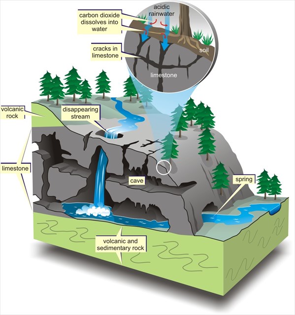
- by the collapse of cave ceilings in areas of limestone karst topography. Karsts are areas with large above-ground limestone outcroppings and underground caves. The caverns are carved by the action of rainwater draining through cracks and joints in the permeable limestone layers. The weak acid of the water makes the limestone soluble and more likely to collapse. Once the cave implodes, the actions of running water enlarge and define the gorge;
- on the uplifted plateaus of limestone where the water flows downhill. The running water cuts into the stone aided by the river's load of sediment, sand and small rocks. A gorge will start to form as a waterfall retreats upstream, eating away at the limestone base as it goes. The falls move backwards, in the opposite direction of the water's flow. Steep gorge wall formation is aided by the freezing and thawing of water to loosen large sections of limestone that tumble to the bottom.
http://www.ehow.com/info_7861109_formation-gorges-limestone-areas.html
|