Cave of Swallows:
Cuestionariopara el registro 
- Por favor lleveuna pequeña cantidad de ácido con usted a las cercanías de la cueva (vinagre o ácido cítrico, por ejemplo). Deje caer unas gotas pequeñas de ácido en la piedra caliza. Por supuesto, la prueba también se puede realizar en casa! Adquirir sólo algunas de cal / caliza y "protege" por lo que el entorno de Sótano de las Golondrinas!
Describalo que observa. (Este experimento ilustra en unos segundos lo que nuestro planeta necesita un millón de años.)
- Cuál es la altura sobre el nivel del mar de la orilla / barranco de "Sótano de Las Golondrinas" ((por favor metro uso como unidad de la respuesta --> 1 metro = 3,28 pies)? (Use su dispositivo GPS para medir la altura. Una desviación de ± 30 metros a la cantidad promedio es aceptada) (opcional, no obligatorio)).
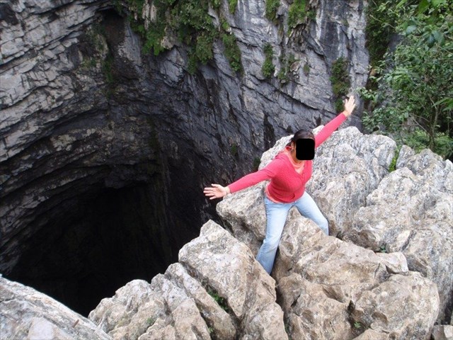
- Tomauna foto tuya con de tu dispositivo GPS y la cueva en el fondo y cargarlo en su registro (opcional, no obligatorio).
Por favorenviar las respuestas a este link! Pulse el earth-button --> 
Questionary for the log 
- Please take a small amount of acid (vinegar or citric acid for instance) with you to the cave / limestone formation. Now dripping a few small drops of acid on limestone. Of course, the test you can also perform at home! Acquire just some lime/limestone and "protects" so the environment of Sótano de las Golondrinas!
Describe what you observe. (This experiment illustrates in seconds for which our planet needs a million years.)
- What is the height above sea level of the edge/ravine of "Sótano de las Golondrinas" ((please use meter as the unit of your answer --> 1 meter = 3,28 feet)? (Use your GPS device to measure the height. A deviation of ± 30 meters to the averaged amount is accepted) (optional, not mandatory)).
- Take a picture of yourself or your GPS device with the cave in the background and load it up with your log (optional, not mandatory).
Please send the answers to this link! Push the earth-button -->
Aufgaben um zu loggen 
- Bitte nehmt euch eine kleine Menge Säure (zum Beispiel Essig- oder Zitronensäure) mit zu der Höhle / Kalkstein Formation. Dort tropft ihr ein paar kleine Tropfen Säure auf Kalkstein. Den Versuch könnt Ihr natürlich auch zu Hause durchführen! Besorgt Euch einfach etwas Kalk/Kalkstein und "schont" die Umwelt der Karstformationen vom Sótano de las Golondrinas!!
Beschreibt was ihr beobachten könnt. (Dieses Experiment verdeutlicht in Sekunden wozu unseren Planeten eine millionen Jahre braucht.)
- Auf welchen Höhenmetern über dem Meeresspiegel befindet ihr euch an der Kante / Schlucht von "Sótano de las Golondrinas" ((bitte verwendet Meter als Maßeinheit für eure Antwort --> 1 Meter = 3,28 Fuß) (Verwendet euer GPS-Gerät um die Höhe zu bestimmen. Eine Abweichung von ± 30 Metern auf den gemittelten Betrag wird akzeptiert) (optional, nicht zwingend)).
- Nehmt ein Bild von euch selbst oder eurem GPS-Gerät mit der Höhle im Hintergrund auf und hängt es eurem Log an (optional, nicht zwingend).
Bitte sendet die Antworten zu diesem Link! Drück den earth-button -->

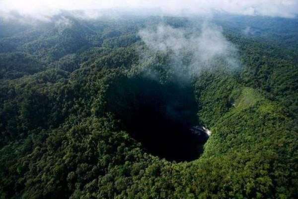
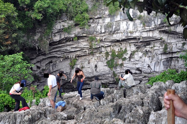
Uno de losabismos naturales más impresionantes del mundo es Sótano de las Golondrinas - Cueva de las Golondrinas. Este agujero en el suelo es tan grande que es casi imposible de comprender su tamaño, incluso si uno está sentado en el borde del mismo.
Agujero Gigante
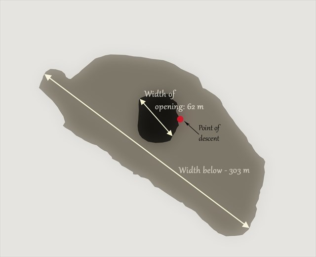
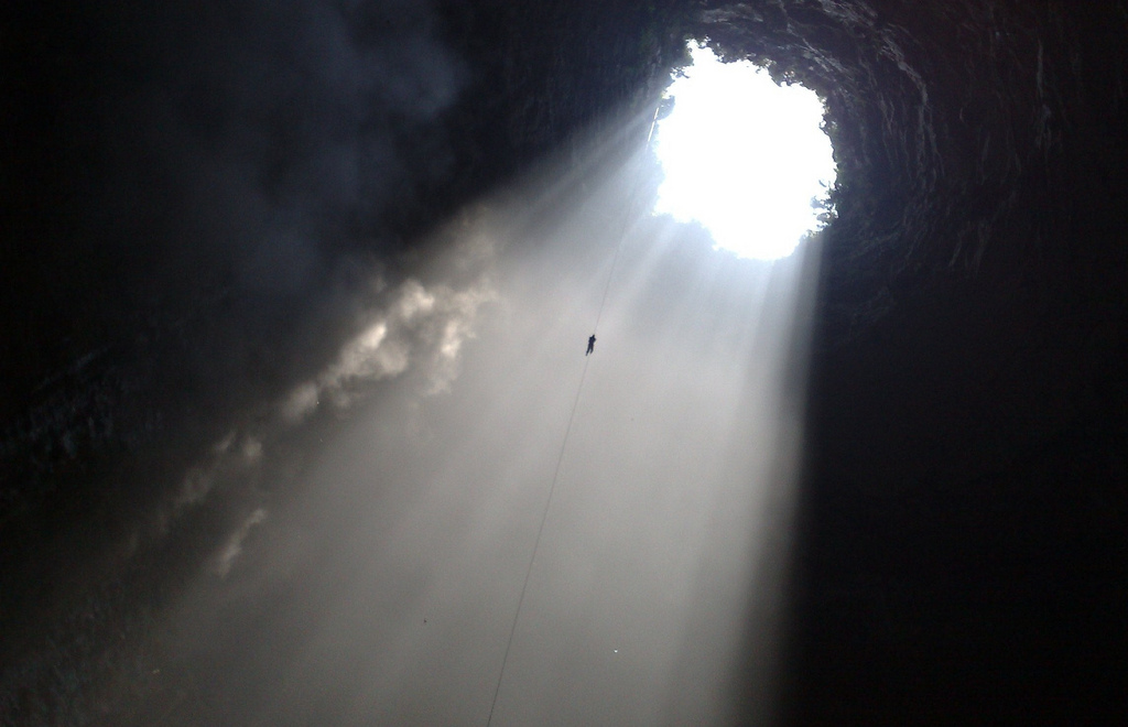
El Sótano de lasGolondrinas es una de las caídas libres más profundas en el mundo. La entrada de este sótano es de forma elíptica, de 49 por 62 m de ancho. Al descender, esta maravilla de la naturaleza es mucho más amplia - en la parte inferior o fondo es de 303 por 134 m (algunas fuentes 305 x 440 m). El área del fondo se puede comparar con tres campos de fútbol.
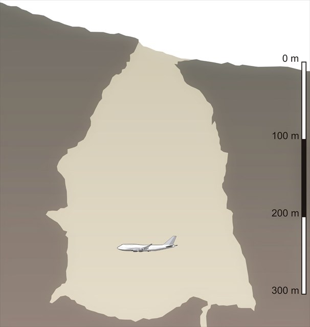
La Profundidaddel eje de entrada cuando se mide desde el borde inferior es de 333 m, de la superior - 372 m.
Esono es todo - en la parte inferior de este eje de entrada continua un estrecho que conduce a través de varios pasos hasta una profundidad de 512 m. Pero poca gente llega ahí - no es la atracción principal aquí. El eje de entrada, desde cualquiera de sus bordes, da directamente hacia abajo. El fondo del sumidero está cubierto con montones de escombros acumulados por años y sin ellos el Sótano de las Golondrinas sería de más de 500 m de profundidad.
Estos sonpuros datos. Y sinceramente - no dicen mucho. Intentemos comprender la profundidad del Sótano de otra manera - Si usted saltara en este agujero, podría caer durante 12 segundos. Cuéntelos en voz alta y vera que eso es mucho!
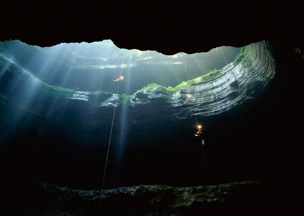
En la temporadade lluvias añade un efecto - varias cascadas pequeñas y grandes que caen directamente en el interior de la cueva, con una caída increíble. Estos sin duda son de las cascadas más altas en una cueva en el mundo.
A ciertas temperaturas y humedades se forman nubes en la parte superior de la cueva. Sí, esta cueva es lo suficientemente grande como para tener verdaderas nubes en el interior!
Geológico - Piedra caliza / Karst
Este increíble sumidero ha sido erosionado por el agua en una falla impermeable de una planicie de piedra caliza. Se formo en roca caliza del Cretácico Inferior y está ubicado en las montañas de la Sierra Madre Oriental a lo largo de 500 km y hasta 3.500 m de altura aproximadamente.
La piedra caliza es una roca sedimentaria compuesta en gran parte de la calcita y la aragonita, que son las diferentes formas cristalinas del carbonato de calcio (CaCO3). Muchas calizas están compuestas de fragmentos de esqueletos de organismos marinos, como los corales o los foraminíferos.
La piedra caliza representa aproximadamente 10% del volumen total de todas las rocas sedimentarias.
La mayoría de las cuevas se forman en karst, un tipo de piedra caliza, dolomita, rocas de yeso que se disuelven lentamente en presencia de agua con un tinte ligeramente ácido. La lluvia se mezcla con dióxido de carbono en la atmósfera a medida que cae al suelo y luego toma más de este gas a medida que se filtra en el suelo. La combinación es una débil solución ácida que disuelve la calcita, el principal mineral de las rocas kársticas.
El agua ácida se filtra hacia abajo en la Tierra a través de las grietas y las fracturas y crea una red de pasajes como un sistema de tuberías subterráneas. Los pasajes se amplían a medida que más agua se filtra hacia abajo, permitiendo que el agua fluya aún más a través de ellos. Con el tiempo, algunos de los pasajes son lo suficientemente grandes como para ganar la distinción de la cueva. La mayoría de tipo de cuevas requieren de miles de millones de años para que amplíen suficientemente como para albergar un ser humano.
Los canales de agua pasan a través de la Tierra hasta llegar a la zona donde las rocas están completamente saturadas con agua. En este caso, las masas de agua continuamente chapotear un lado a otro, explicando por qué muchas cavernas toman una forma casi horizontal.
Due to subterranean drainage, there may be very limited surface water, even in the absence of any rivers and lakes. Many karst regions display distinctive surface features, with cenotes, sinkholes or dolines being the most common. However, distinctive karst surface features may be completely absent where the soluble rock is mantled, such as by glacial debris, or confined by a superimposed non-soluble rock strata. Some karst regions include thousands of caves, although evidence of caves large enough for human exploration is not a required characteristic of karst.
El Sótano de las Golondrinas, no es la única formación kárstica de la zona. Cerca la ciudad de Aquismón, se encuentran varios pozos muy profundos y algunos sistemas de cuevas muy largas, entre ellos el gigante Sistema Purificación, donde se han explorado 95 km y hasta 957 m de profundidad. Hay sumidero con mayor en volumen que el Sótano de las Golondrinas, Hoya de las Guaguas con 202 m de profundidad del eje de entrada y una profundidad total de 430 m. Sótano del Barro, 67 km al este ofrece una aún más profunda caída caída libre con 410 mts!
Aves
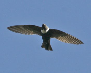
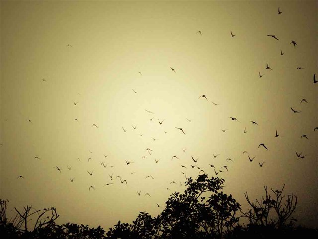
Al amanecer, alrededor de las 6:00, aquí suceden cosas increíbles. Los observadores en el borde del abismo, comienzan a notar primero a pequeña escala, las manchas de color gris claro dando vueltas lentamente a lo lejos. Poco a poco, estas manchas se hacen más grandes y más grandes - Se trata de miles de vencejos de cuello blanco (Streptoprocne zonaris Shaw, 1796) que se levantan desde el fondo del sumidero. Las aves se mueven simultáneamente, en movimiento primitivamente bien estudiado: esta ascensión vertiginosa en espiral deja mareados e incluso hipnotizados a los observadores. En cuanto las aves llegan a la superficie su vuelo se vuelve caótico y errático - aquí están esperando numerosas aves de presa. Al poco tiempo, en pocos minutos todos los vencejos desaparecen hasta la noche.
Este evento se prolonga durante unos 20 - 30 minutos. Se lleva a cabo cada mañana y lo más probable es que lleve haciéndose desde hace miles de años. Por la noche, los pájaros se reúnen por encima de la cueva y luego, rápidamente, con las alas plegadas y silban cayendo vertiginosamente hacia la boca del abismo - miles y miles de desesperados pájaros grises escapan de sus depredadores...
Las aves tienen una buena razón para vivir aquí – los nidos colgantes en las paredes están a salvo de los depredadores.
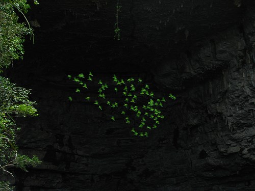
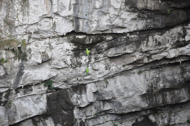
Pero aquí reside otro pájaro, incluso más espectacular. Estos son los periquitos verdes (Aratinga holochlora Sclater, 1859) - hermosos loros verdes. Además, estas aves también se elevan desde la cueva volando en espiral. Aparecen por debajo como manchas verdes muy animadas.

Ambas especies:

One of the most impressive sinkholes in the world is Sótano de las Golondrinas - Cave of the Swallows. This hole in the ground is that large that it is nearly impossible to comprehend it - even if one is sitting at the rim of it.
Giant hole
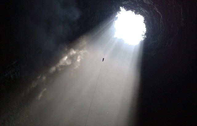
Sótano de las Golondrinas offers one of the deepest freefall drop in the world. Entrance of this sinkhole is elliptical in shape, 49 by 62 m wide. When ascending deeper, this natural wonder becomes much wider - at the bottom it is 303 by 134 m large (some sources state 305 x 440 m). The area of the bottom can be compared to three football fields.
Depth of the entrance shaft when measured from the lower rim is 333 m, from the upper one - 372 m.
That's not all - at the bottom of this entrance shaft there is narrow continuation which leads through several steps up to 512 m depth. But few people go there - this is not the main attraction here. This smaller shaft goes directly down. Thus it is possible that the bottom of sinkhole is covered with heap of rubble and without it Sótano de las Golondrinas would be more than 500 m deep.
These were pure figures. If frankly - they don't tell much. Let's try it otherwise - if you would jump in this hole, you would fall down for 12 seconds. Count it - that's a lot!
In rainy season there is added effect - several smaller and larger waterfalls are falling directly inside the cave, in one incredible plunge. These certainly are some of the tallest cave waterfalls in the world.
At certain temperatures and dampness there form clouds at the upper part of the cave. Yes, this cave is large enough to have true clouds inside!
Geological - Limestone / Karst formation
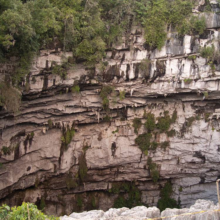
This incredible sinkhole has been shaped by water in a fault of impermeable limestone plain. It has formed in lower Cretaceous limestone and is located in the approximately 500 km long and up to 3,500 m high Sierra Madre Oriental mountains.
Limestone is a sedimentary rock composed largely of the minerals calcite and aragonite, which are different crystal forms of calcium carbonate (CaCO3). Many limestones are composed from skeletal fragments of marine organisms such as coral or foraminifera.
Limestone makes up about 10% of the total volume of all sedimentary rocks.
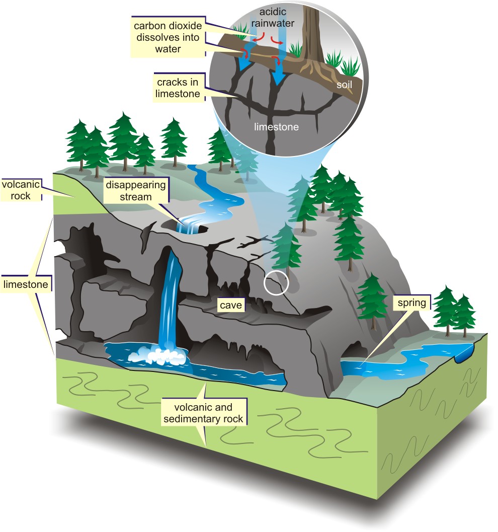
The most caves form in karst, a type of landscape made of limestone, dolomite, and gypsum rocks that slowly dissolve in the presence of water with a slightly acidic tinge. Rain mixes with carbon dioxide in the atmosphere as it falls to the ground and then picks up more of the gas as it seeps into the soil. The combination is a weak acidic solution that dissolves calcite, the main mineral of karst rocks.
The acidic water percolates down into the Earth through cracks and fractures and creates a network of passages like an underground plumbing system. The passages widen as more water seeps down, allowing even more water to flow through them. Eventually, some of the passages become large enough to earn the distinction of cave. Most of these solutional caves require more than over thousands to millions of years to widen large enough to hold a human.
The water courses down through the Earth until it reaches the zone where the rocks are completely saturated with water. Here, masses of water continually slosh to and fro, explaining why many caverns lay nearly horizontal.
Due to subterranean drainage, there may be very limited surface water, even in the absence of any rivers and lakes. Many karst regions display distinctive surface features, with cenotes, sinkholes or dolines being the most common. However, distinctive karst surface features may be completely absent where the soluble rock is mantled, such as by glacial debris, or confined by a superimposed non-soluble rock strata. Some karst regions include thousands of caves, although evidence of caves large enough for human exploration is not a required characteristic of karst.
Sótano de las Golondrinas by far is not the only karst formation here. Here, around Aquismón town, are located several very deep sinkholes and some very long cave systems including the giant Sistema Purificación, explored to 95 km length and up to 957 m depth. There is even larger sinkhole by volume - Hoya de las Guasguas with 202 m deep entrance shaft and total depth of 430 m. Sótano del Barro 67 km to the east offers even deeper freefall drop - 410 m!
Birds
At sunrise, around 6:00, here happen incredible things. Observers at the rim of the sinkhole at first notice small, light grey spots slowly circling far below. Gradually these spots become larger and larger - these are thousands of white-collared swifts (Streptoprocne zonaris Shaw, 1796) rising up from the sinkhole. Birds are moving simultaneously, in well studied primeval movement: this spiralling ascent leaves dizzying and even hypnotic effect on observers. As the birds reach the surface their flight becomes chaotic and erratic - here are waiting numerous birds of prey. Soon, in a few minutes all swifts disappear until the evening.
This event continues for some 20 - 30 minutes. It takes place every morning and most likely - since thousands of years. In the evening birds gather above the cave and then possibly quickly, with folded wings and whistle fall down - thousands and thousands of desperate grey birds escaping their predators...
Birds have good reason to live here - nests on the overhanging walls are safe from predators.
Swifts have given a name to the sinkhole - "Sótano de las Golondrinas" in Spanish means "Basement of the Swallows".
But here lives another, even more spectacular bird. These are the green parakeets (Aratinga holochlora Sclater, 1859) - beautiful green parrots. Also these birds rise up from the cave flying in spirals. They appear as lively green spots far below.
Both species:
Special thanks to lalonava!
He is responsible for the translation into Spanish!!
THX