CORSE KNOWN & UNKNOWN 4 - CAPU D'ORTO
[EN]
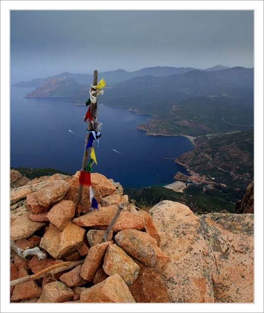
This cache will lead you to the top of Capu D'Orto, which is the fifth highest top in the Calanche region. There is a fantastic view on the entire Porto bay, on Piana town and during good weather on rocky peninsula Capu Rossu in the background. The way up should last some 2-3 hours depending on your physical skills and weather. The same time should be reserved for the way down.
Access:
The best is to start the ascent from the parking place near Piana village. After cca hour and a half of walking to mild slope through forest (marked by paint streaks) you will reach crossroads with pointers. Take the left track and at the next crossroads the right track. After one hour of steeper ascending in beatiful landscape of Calanches full of strange rocky formations and shapes, you will reach the top. The track is marked by paint in the beginning and by stone pills later. Take the most beaten track. Be careful during rainy weather when the rocks near the top may be very slippery.
The cache itself is hidden on the side peak.
[FR]
Cette cache vous emmenera jusqu'au sommet du Capu d'Orto, qui est le point culminant dans le domaine des Calanche, ou vous avez une vue fantastique sur la baie entiere de Porto, la ville de Piana et en cas du beau temps a l'arriere-plan une vue sur une peninsule rocheuse de Capu Rossu. Selon la condition physique et le temps votre l'escalade devrait prendre entre 2-3 heures. Pour la descente il faut compter avec la meme duree.
Acces:
Il est preferable de commencer sur le parking pres du village de Piana. Apres environ une heure et demie d'une longue montee a travers la foret (balises par des eclaboussures des couleurs) vous arrivez a la croisee des chemins. Ici, tournez a gauche et au prochain croisement a droite selon le panneau. Apres environ une heure, d'une plus forte montee a travers le beau paysage Calanches presente par des groupes et formes de rochers obscurs, vous arrivez vers le haut. Le chemin est toujours initialement marque avec une couleur, puis marque par les tas de pierres. Suivez toujours les sentiers les plus frayes. Faites attention au temps pluvieux, des roches surtout dans le passage fin pourraient-ils etre tres glissant.
Recherchez votre geocache au sommet lateral.
[D]
Dieser Cache fuhrt Sie zum Gipfel von Capu D'Orto, dem hochsten Gipfel der Region Calanche, von hier aus gibt es eine fantastische Aussicht auf die ganze Bucht Porto, das Stadtchen Piana und bei gutem Wetter auch auf die felsige Halbinsel Capu Rosso. Je nach Ihrer korperlichen Leistungsfahigkeit und dem Wetter sollte die Wanderung bergauf ca. 2-3 Stunden dauern. Fur die Ruckwanderung sollte man mit der gleichen Zeit rechnen.
Zugang:
Den Aufstieg sollte man am besten auf dem Parkplatz nicht weit vom Dorf Piana anfangen. Ungefahr nach anderthalb Stunden des Aufstiegs durch den Wald (markiert mit Farbenspritzen) kommen Sie zu einer Kreuzung mit Wegweisern. Hier biegen Sie links ab und an der nachsten Kreuzung wieder rechts nach dem Wegweiser. Nach ungefahr einer Stunde eines schwierigeren Aufstiegs durch die herrliche Landschaft von Calanches voll von bizzaren Felsenformen kommen Sie endlich zum Gipfel. Der Weg ist am Anfang noch rot markiert, spater nur mit Steinhaufen. Folgen Sie immer dem am haufigsten benutzten ausgetretenen Pfad. Seien Sie vorsichtig vor allem bei schlechtem Wetter, wenn die Felsen hauptsachlich am Ende sehr rutschig sein konnen.
Den eigenen Cache suchen Sie auf dem Seitengipfel.
[CZ]
Tato kes Vas zavede k vrcholu Capu D'Orto, ktery je nejvyssim vrcholem v oblasti Calanche a odkud se Vam naskytne fantasticky vyhled na cely zaliv Porto, mesto Piana a za dobreho pocasi v jeho pozadi i na skalnaty poloostrov Capu Rossu. Dle telesne zdatnosti a pocasi by Vam cesta nahoru mela trvat neco mezi 2-3mi hodinami. Na cestu dolu je potreba pocitat s cca stejnou dobou.
Pristup:
Vystup je nejvhodnejsi zacit na parkovisti nedaleko obce Piana. Po cca hodine a pul pozvolneho stoupani lesem (znaceno strikanci barvy) dojdete na rozcesti s ukazateli. Zde se dejte vlevo a na dalsim rozcesti vpravo dle ukazatele. Po cca hodine ostrejsiho stoupani prekrasnou krajinou Calanches plnou obskurnich skalnich seskupeni a tvaru dojdete na samotny vrchol. Cesta je zpocatku jeste znacena barvou pote ji vytycuji hromady kameni. Drzte se vzdy te nejvic vyslapane cesty. Pozor si dejte predevsim za destiveho pocasi, kdy mohou byt skaly hlavne v koncove pasazi velmi kluzke.
Vlastni kes hledejte na bocnim vrcholu.
--------------------------------------------------------------------------------------------------------------------
On the cache box or on the logbook cover you can find some bonus codes
for final cache (GC3HWN7).
Please log in english, if you can (especialy for "Need maintenance" logs).
Corse known & unknown miniserie:
- Corse known & unknown 1 - Iles Lavezzi (GC3HWAA)
- Corse known & unknown 2 - View on Ile De La Giraglia (GC3HWHJ)
- Corse known & unknown 3 - Monte D'Oro (GC3HWEX)
- Corse known & unknown 4 - Capu D'Orto (GC3HWJW)
- Corse known & unknown Final (GC3HWN7)