Sólheimajökull
Welcome to the glacier Sólheimajökull, spectacular tongue of ice stretching down from Mýrdalsjökull, the fourth largest glacier in Iceland.
You can usually get around here in the summer from June to August with a normal car. Other times you may need a 4x4 Jeep.
Sólheimajökull is an outlet glacier draining the Mýrdalsjökull ice cap in southern Iceland. Mýrdalsjökull covers the Katla central volcano, one of the most active volcanoes in Iceland. Sólheimajökull is ~ 15 km long, 1-2 km wide and covers 44 km². It descends from the Katla caldera at 1505 m a.s.l. (Hábunga), and terminates ~ 100 m a.s.l. The base of the glacier is at 11 m above present sea-level, 0.8 km inside the present margin.
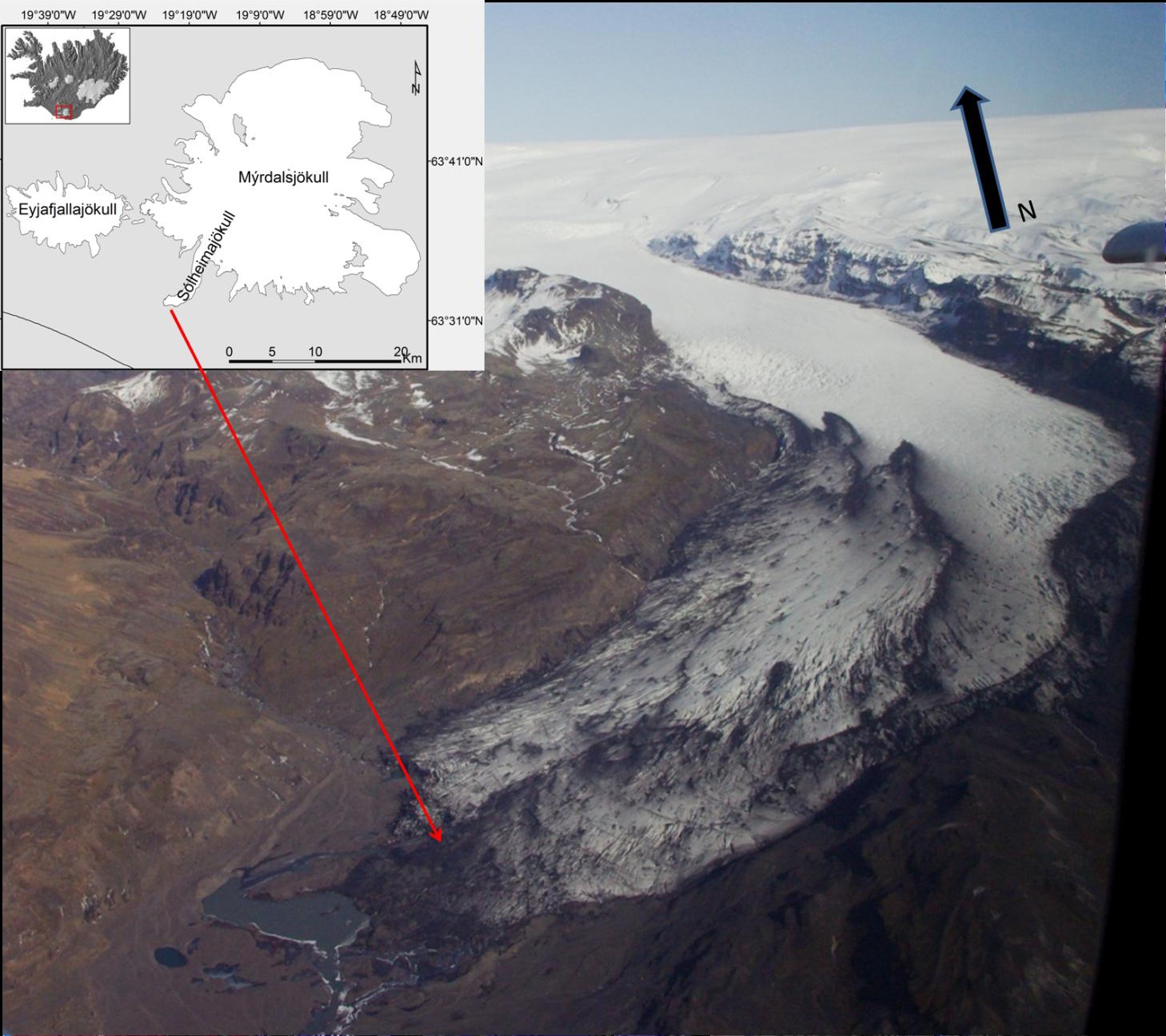
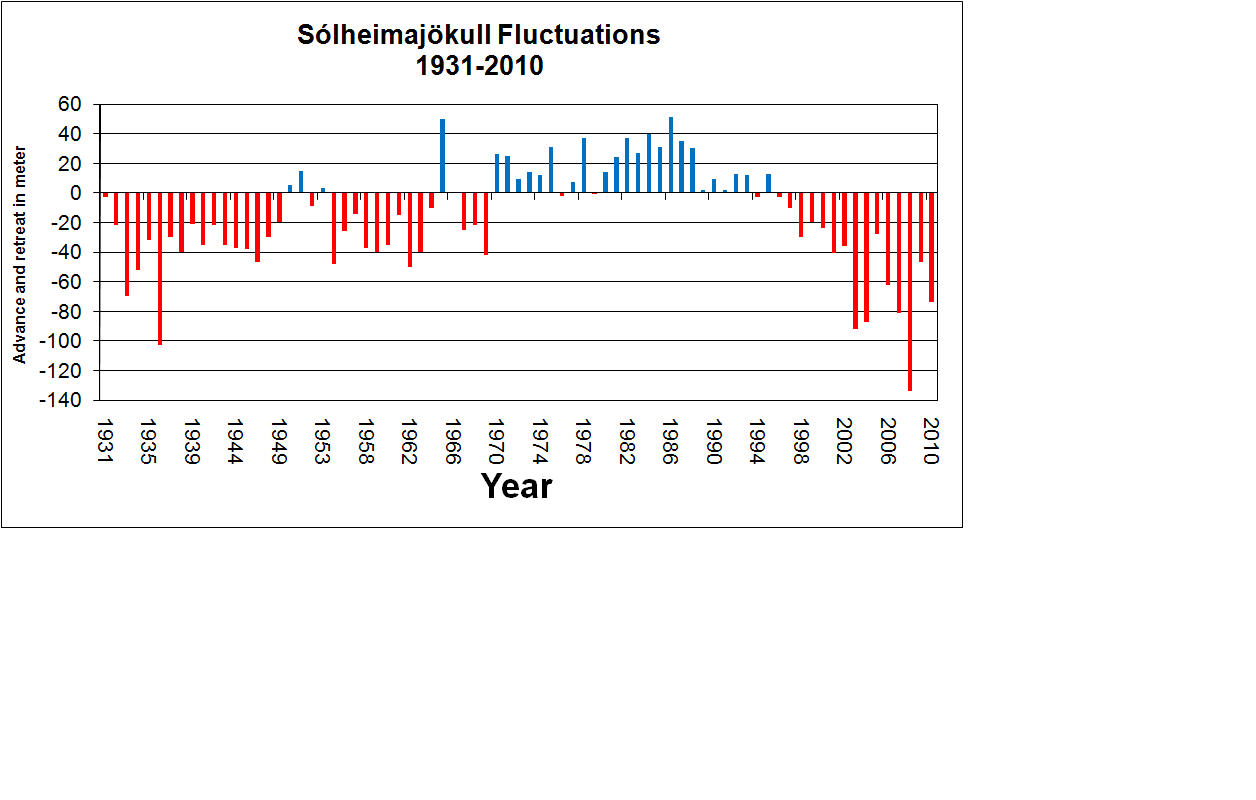
Subglacial eruptions of Katla have caused jökulhlaups at Sólheimajökull, with great impact on the proglacial landscape. The marginal fluctuations of Sólheimajökull correspond well to changes in the climate. In 2010, the glacier had retreated 1255 meter since annual ice front measurements were initiated in 1931, however, punctuated by a period of advance from 1969-1995. From 1904-2009 Sólheimajökull lost 2.2 km2 (70%) of the frontal part of the snout by melting. The glacier advanced about 900 metres during the last few centuries, but retreated greatly from 1930 to 1964. In the nineties it advanced and almost managed to cover the Jokulhaus hill. Now this wallay glacier is retreating exceptionally rapidly ... in fact at the equvalent of a footballfield annually.
Glacier Facts
A glacier (in Icelandic Jökul) is defined as an annual accumulated and translated masses of ice and snow that has begun to move, by gravity. Glaciers are the world's largest resource of fresh water and the second largest accumulation of water by the oceans, the Lambert Glacier in east Antarctica is the world's largest glacier. Simply put, occurs frequently in mountain glaciers or polar regions of the snow accumulate and do not have time to melt away, the folds in layers. By its own weight, converted the snow into ice by the pressure and finally reached critical mass when the ice starts to move.
Glaciers often affects those around sharply and leaving traces in nature, making them important in geological studies.
Different types of glaciers.
Glaciers can be classified in several ways and by different properties. A physical classification is to classify glaciers temperate or polar.
Temperate or warm, glaciers are found in lower latitudes and are characterized in that the entire ice sheet is at its melting point, although the upper parts may freeze in winter. This results in the flowing water is always available in and around the Glacier and glacial slides against the surface and is highly erosive, making them very important in glacial geomorphological processes.
Polar, or cold, glaciers are primarily found in polar areas. These characterized in that the entire mass is frozen and little or no water is available. These glaciers are the ground frozen, which means that the surface is not significantly affected by them. Their erosive properties are therefore negligible.
Furthermore, often classified as glacial its morphological properties, namely emergence method, and appearance. There are many different types and only the main is reported below:
Niche Glacier - a glacier that is in a pot or bowl.
Valley glacier - a glacier that flows along a valley.
Ice fields or ice cap - a large glacier that flows in many directions and is not constrained by a valley.
Piedmontglacier - a glacier that flows out and spreads out in the lowland areas. They are often lobed in appearance.
Ice sheet or continental glacier - a very large field of ice covering the entire continents. Its movements are radial and little influenced by bottom topography.
Glacial Formation
A good picture of a glacier is a snow collector. Glaciers often occur in valleys or crevices on the leeward side of the mountain where snow is transported by wind and collected in considerable quantities.
When the snow is aggregated over several years and change their physical properties are formed glacier. Snow is often very low density and is composed of very fine hexagonal crystals. These are packed and melts and is converted into rounder and smaller forms. While draining melt water from these processes down and freezes again in the pore spaces below. These processes lead to dramatic increases in density and decreases the porosity. The heavy and dense snow called firn and has a density of 0.4-0.8 kg / dm 3, as compared with new snow from 0.05 to 0.07 kg / dm ^ 3. How long it takes for firn formed depends on external conditions, especially temperature and precipitation. In temperate regions, which usually also has a good rainfall, it can go as fast as 3-5 years, while in arid areas can take over 100 years.
If this process is continued gradually formed glacier. This process differs from the previous in that the larger crystals are formed by recrystallization. When the density has increased, and especially the porosity decreased, resulting hydrostatic pressure in firnmassan and crystals "grow up" in any direction and with the percolating water sealed cavities. The only remaining air is now trapped in air bubbles. The final glacier has a density of ≈ 0.9 kg / dm ^ 3.
To log this earth cache as found, you must:
1. Been yourself at the place of this Earth Cache, AFTER this cache was published.
2. Email the answer to the following six questions to the cache owner.
A. What color is the glacier?
B. What makes the different colors of the glacier?
C. During which years reduced the glaciers with more than 100 m during the past hundred years?
D. How many meters is it to the glacier edge from the coordinates?
E. The glacier is about 15km long, how many years would it take for the glacier to disappear entirely if it melts at the same rate as between the years 2000-2010?
Use the above table and attach the calculation of the response. Do NOT use the information from the information board in place.
F. Give the name of three (3) other Glaciers in Iceland.
3. Feel free to load up one (or more) photos of you and the glacier. (Not requirements but desirable)