A piece of Germany - Castrop-Rauxel in Cape Roca Traditional Geocache
A piece of Germany - Castrop-Rauxel in Cape Roca
-
Difficulty:
-

-
Terrain:
-

Size:  (small)
Please note Use of geocaching.com services is subject to the terms and conditions
in our disclaimer.
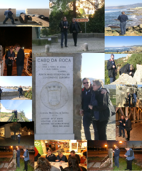
Cabo da Roca (Cape Roca) is a cape which forms the westernmost extent of mainland Portugal and continental Europe (and by definition the Eurasian land mass). The cape is in the Portuguese municipality of Sintra, west of the district of Lisbon, forming the westernmost extent of the Serra de Sintra.
This cache is part of the memory of some sites visited on the Portuguese coast and moments spent with D_und_H (Doro und Horst) for a few short Christmas holidays of 2011.
Castrop-Rauxel is a former mining city in the eastern part of the Ruhr Area. Castrop-Rauxel is between Dortmund to the east, Bochum (south), Herne (west), and to the north, Recklinghausen, Datteln and Waltrop. The urban area of Castrop-Rauxel has a total expanse of 51.66 km2 (19.95 sq mi). The Halde Schwerin is marked as the highest point of the city with 147 m over NN, the lowest point is the Pöppinghauser street beside house number 264 with 50.2 m over NN. The city is divided into 15 districts, listed in order from north to south: Becklem, Henrichenburg, Ickern, Habinghorst, Pöppinghausen, Deininghausen, Rauxel, Bladenhorst, Behringhausen, Castrop, Dingen, Schwerin, Obercastrop, Frohlinde and Merklinde. First mentioned in 834 as "Villa Castorpe",[citation needed] the city of Castrop was founded in 1902 by merging the municipalities Castrop, Obercastrop and Behringhausen. On April 1, 1926 Castrop-Rauxel was formed when Castrop merged with 10 other municipalities. During World War II, a plant at Castrop-Rauxel used the Bergius process to produce synthetic (German: Ersatz) oil products. In 1975, the village of Henrichenburg was annexed and Castrop-Rauxel became part of the Recklinghausen (district). In 1984 the last of 7 coal mines at Castrop-Rauxel ("Erin") closed. Castrop-Rauxel has access to three major highways, the Emscherschnellweg A 42,the Sauerlandlinie A 45 and the A 2. There are 3 railway stations within the city. The central station (Castrop-Rauxel Hauptbahnhof) on the Cologne-Minden Railway is located in the suburb of Rauxel. Connecting Castrop-Rauxel to the western Ruhr cities like Duisburg, Oberhausen, Essen, Gelsenkirchen, Herne and in the east to Dortmund and Hamm. The unmanned stations of Castrop-Rauxel South (Castrop-Rauxel Sued) and Castrop-Rauxel Merklinde on the Emschertalbahn are offering hourly services with trains to Dortmund, Herne and Dorsten. Located in the city centre is the central bus station Muensterplatz. From here passengers can travel to almost all suburbs and to neighboring cities like Herne, Dortmund and Bochum. The Rhine-Herne Canal runs right through Castrop-Rauxel; Castrop-Rauxel also has a small Yacht club on this body of water. Castrop-Rauxel has been attempting to change from a former mining city to a city with a modern lifestyle, high recreational value, new economy companies, a 27 hole golf course, and various cultural events. The WLT (Westphalian State Theater) is the oldest and most relevant source of theatrical entertainment in Castrop-Rauxel. There is one cinema with two screens in Castrop. Castrop’s history is closely connected to horse racing, the Reiterbrunnen in the very center of Castrop’s market square is a reminder of the race days on the Naturhindernisbahn, now part of the Goldschmieding Park.
Additional Hints
(Decrypt)
haqre gur fgbar