Source of Lison EarthCache
-
Difficulty:
-

-
Terrain:
-
Size:  (not chosen)
Please note Use of geocaching.com services is subject to the terms and conditions
in our disclaimer.
Source of Lison
English:
The Lison is a river in France, which runs in the department of Doubs, in the region Franche-Comte. It rises in the municipality of Nans-sous-Sainte-Anne, from a rich karst spring, the Source du Lison. This spring pours out under conditions of drought in nearly 600 liters of water per second and is about the source of the Loue, the most sparkling in the Jura. The underground power source is carried partly by the Ruisseau Château-Renaud, in part by the Lizon Supérieur, which both disappear further up the catchment area of the surface and percolate. The Lison drains and flows generally north to 25 kilometers in the municipality of Chatillon-sur-Lison as a left tributary of the Loue. The whole catchment area of Lison is a protected area under the Natura 2000 project.
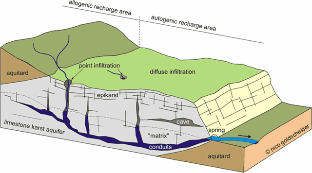
Karst spring:
A karst spring is a spring that is part of a karst system. That includes the underground drainage of a much larger area, which means that karst springs often have a very large discharge. Because of their often conical or bowl shape, such water sources are also known in German-speaking lands as a Topf ("pot") which is reflected in names such as Aachtopf (the source of the Radolfzeller Aach) or Blautopf (the source of the Blau river in Blaubeuren).
Karst springs are usually the end of a cave system at the place where a river cave reaches the Earth's surface. Thus, it is often possible to enter the caves at karst spring and explore them.
Karst:
Karst topography is a geological formation shaped by the dissolution of a layer or layers of soluble bedrock, usually carbonate rock such as limestone or dolomite, but has also been documented for weathering resistant rocks, such as quartzite given the right conditions.
Due to subterranean drainage, there may be very limited surface water, even in the absence of any rivers and lakes. Many karst regions display distinctive surface features, with cenotes, sinkholes or dolines being the most common. However, distinctive karst surface features may be completely absent where the soluble rock is mantled, such as by glacial debris, or confined by a superimposed non-soluble rock strata. Some karst regions include thousands of caves, although evidence of caves large enough for human exploration is not a required characteristic of karst.
français:
Le Lison est une rivière française qui coule dans le département du Doubs, dans la région Franche-Comté. C'est un affluent en rive gauche de la Loue, donc un sous-affluent du Rhône par la Loue, le Doubs et la Saône.
Description du cours:
Sa source se trouve dans la commune de Nans-sous-Sainte-Anne, mais il est probablement une résurgence du ruisseau de Château-Renaud, qui prend sa source à Sainte-Anne et traverse Crouzet-Migette où il se perd. Le débit interannuel moyen du Lison à sa source est de 5,35 m³ par seconde.
Après Nans-sous-Sainte-Anne, le Lison longe Saraz, traverse la commune d'Éternoz où il reçoit le ruisseau de la Vau, puis Myon où il reçoit le Todeur, Échay où se trouve une station d'épuration des eaux, Cussey-sur-Lison où il reçoit la Goulue, puis il longe Lizine et Châtillon-sur-Lison où il se jette dans la Loue.
Exsurgence:
Une exsurgence est une source dont l'eau provient d'un réseau hydrogéologique endogène d'un massif, généralement karstique.
Il existe des exsurgences marines jusqu’à plusieurs dizaines de mètres de profondeur et jusqu’à plusieurs centaines de mètres du rivage. Ces exsurgences ont parfois été utilisées par des marins comme source d'eau potable en pleine mer.
Karst:
Le karst est une structure géomorphologique résultant de l'érosion hydrochimique et hydraulique de formations de roches carbonatées, principalement de formations calcaires. Des phénomènes d'érosion de type karstique se manifestent aussi dans des structures « pseudokarstiques ». Les structures karstiques concernent environ le cinquième de la superficie continentale de la Terre. Les karsts présentent pour la plupart un paysage tourmenté, un réseau hydrographique essentiellement souterrain et un sous-sol creusé de nombreuses cavités : reliefs ruiniformes, pertes et résurgences de cours d'eau, grottes et gouffres… Sur les marges sud et ouest du Massif-central français, les plateaux karstiques sont dénommés causses.
L'étude du karst est la karstologie. À l'étude des cavités et réseaux hydrogéologiques du karst sont notamment associées la spéléologie, la plongée souterraine et la biospéologie.
Questions to answer:
The natural waterfall has helped to relief the human labour.
1] Which occupations have profited most?
2] Estimate the height of the waterfall
3] Look at the Source of Lison. Explain in your own words, why it is definitely a "Karst Spring"?
La chute d'eau naturelle a fait le travail humain.
1] Quelles sont les professions qui en ont le plus profité.
2] Estimer la hauteur de la cascade.
3] Regardez la chute d'eau. Expliquez dans vos propres mots, qu'est ce qu'une "source karstique" (Exsurgence).
Send the Answers to my Geocaching Account. But don't wait for the log permission. I will contact you, if anything is wrong!

Additional Hints
(No hints available.)