VG - GANDARA
 |
|
| Português |
English |
| VG - GANDARA - A CACHE |
VG - GANDARA - THE CACHE |
|
| Um VG que já conheço a sua localização há mais de 30 anos, quando ainda morava nesta zona, e a minha casa não ficava a mais de 700 metros deste local. |
I know the location of this VG for more than 30 year, when my residence was nearby, once my house wasn’t more than 700 meters from this place.
|
 |
| Muitos foram os passeios que me levaram até este sítio, e embora hoje em dia a paisagem esteja um pouco alterada, uma vez que já não há o mesmo cuidado com os pinhais, estes nalgumas zonas não têm o mesmo acesso que nós utilizávamos. |
For many times I went to this place, today the landscapes are a little different, it changed once the people who live in these locations isn’t as many as in the past, and there’s not the same care with the forest.
|
 |
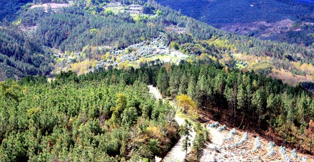
| Por aqui sempre podemos encontrar uma vegetação interessante, e ter uma vista sobre os montes em redor, que é tão agradável quando o céu está azul, ou mesmo quando o temos pintado com as nuvens brancas. |
On our journey to the cache we can find a very interesting vegetation, and have a great view on the surrounding mountains, which is as pleasant with the blue sky, or even with the white clouds in the sky.
|
 |
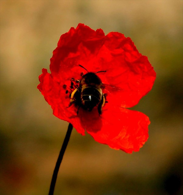
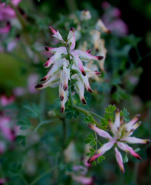
| A fauna e a flora da zona pode proporcionar-nos excelentes fotografias, basta que tenhamos um pouco de tempo e estejamos atentos ao que está em redor. |
In the area we can see a diversity of fauna and flora, great to provide us great motives to our photos, we just need to look around for everything that is near us.
|
 |
| O acesso a esta cache pode ser feito a partir de qualquer um dos pontos de acesso indicados, pois essas estradas estão em muito boas condições de circulação. A partir daí e até ao estacionamento a estrada já não se encontra asfaltada, mas qualquer veículo pode passar sem a mínima dificuldade, uma vez que tudo está muito bem arranjado. |
You can reach this place from any of the access points, once they are all in good conditions. From the access points to the parking place you will have a road with no asphalt, but any vehicle can go there, with not a single problem, on every season of the year, once it is very well preserved.
|
 |
| A partir do estacionamento tem que ser mesmo a pé, e aí podem escolher a abordagem pela esquerda ou pela direita (pelo meio é só para quem quiser fazer corta-mato, mas não vai ganhar nada com isso), e em breves momentos estarão no VG a poucos metros da cache. |
From the parking place you have to walk, there’s no other way, so you can decide to go up from the left or from the right (on the middle it’s also possible to reach the top, but you won’t gain anything with it), and in a few moments you will see the VG and a few meters after the cache is next to you,
|
 |
| Vértices Geodésicos |
Geodesic vertices |
|
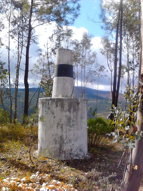
Conjunto de todos os vértices geodésicos e das suas relações geométricas, distribuídos pelo país, colocados em posições dominantes de forma a garantir intervisibilidade, devidamente coordenados. Estão materializados através de diversas formas geométricas, como pirâmides ou troncos de cone sobre cilindros (bolembreanas) ou são coincidentes com estruturas já existentes.
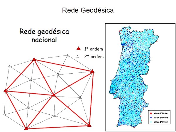
Um VG ou vértice geodésico (popularmente chamado "talefe" em Portugal, e "Pinoco" no Norte de Portugal) é um sinal que indica uma posição cartográfica exacta e que forma parte de uma rede de triângulos com outros vértices geodésicos. São escolhidos sítios altos e isolados com linha de visão para outros vértices. A rede geodésica portuguesa é formada por vértices geodésicos que se dividem em três ordens de importância:
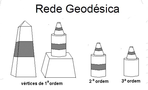
1ª Ordem - pirâmides distando 30 a 60 km
2ª Ordem - cilindro + cone listados distando 20 a 30 km
3ª Ordem - cilindro + cone distando 5 a 10 km
O número de vértices existentes na totalidade do território (Portugal Continental e Regiões Autónomas) é, actualmente, de cerca de nove mil, repartidos por vértices de: Continente: 1ª Ordem (cerca de 120), 2ª Ordem (cerca de 900) e 3ª Ordem (com uma densidade aproximada de 1 vértice por cada 10 km²) Arquipélago dos Açores: cerca de 500 Arquipélago da Madeira: cerca de 150 A RGN é a infra-estrutura básica onde se apoia toda a cartografia do País, e que serve todos aqueles (empresas, autarquias e outros organismos públicos e privados) que, por força das suas actividades, necessitam de referenciar geograficamente os seus projectos (os Planos Directores Municipais, por exemplo). |
Set of all the geodesic vertices and its geometric relations, distributed in the country, placed in dominant form positions to guarantee intervisibilidade, duly coordinate. They are materialized through diverse geometric forms: as pyramids or trunks of cone on cylinders (bolembreanas) or are coincident with already existing structures (curches, lighthouses monuments etc etc.)
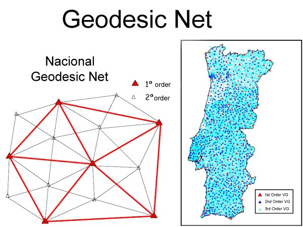
A VG or geodesic vertex (popularly called " talefe" in Portugal, and " Pinoco" in the North of Portugal) it is a signal that indicates a cartographic position exacta and that it forms part of a net of triangles with other geodesic vertices. High and isolated small places with line of vision for other vertices are chosen. The Portuguese geodesic net is formed by geodesic vertices that are divide in three orders of importance:
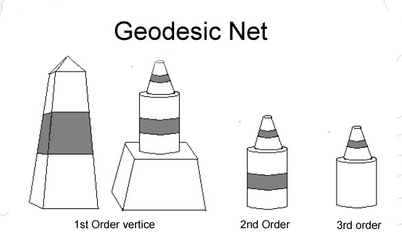
1st Order - pyramids apart betwenn 30 km and 60km
2nd Order - cylinder + cone apart 20 to 30 km
3rd Order - cylinder + cone apart 5 to 10 km
The number of existing vertices in the totality of the territory (Continental Portugal and Autonomous Regions) is, currently, of about nine a thousand, distributed for vertices of: Continent: 1ª Order (about 120), 2ª Order (about 900) and 3ª Order (with an approach density of 1 vertex for each 10 km ²) Archipelago of the Açores: about 500 Archipelago of Madeira: about 150 the RGN is the basic infrastructure where if the cartography of the Country supports all, and that it serves all those (public and private companies, autarchies and other organisms) that, for force of its activities, they need to mention its geographically projects (the Municipal Director Plan, for example).
|