Galilea ist ein entzückendes kleines Bergdorf im Westen Mallorcas. Es liegt in 400 m Höhe am Fuße des
Puig de Galatzó in der Serra Tramuntana in malerischer Umgebung. Bereits die serpentinenreiche Anfahrt von Süden über Es Capdellà (alternativ kommt man von Norden über Puigpunyent) ist ein spektakuläres Erlebnis. In der Nähe reizt der
Puig de Bauçà (615 m) zur Besteigung (
GC16TZ4), zu seinen Füßen beginnt eine der schönsten Kurzwanderungen in dieser Region. Bei dem hübschen Kirchplatz in der Dorfmitte laden zwei kleine Cafes zu
Cortado und Mandelkuchen. Von hier aus hat man einen fantastischen Blick bis zur Küste bei Peguera.
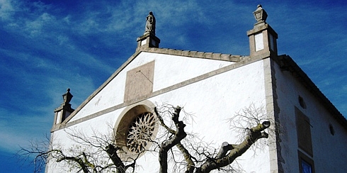 Iglesia / Church / Kirche
Der Kurzmulti startet auf dem Platz vor dem Kirchlein, hier ermittelt Ihr die Koordinaten des Finals. (Dieses markiert zugleich den Startpunkt der traumhaften Wanderung von Galilea nach Son Font, über die dort eine Wegetafel informiert.) Den Weg von der Kirche zum Final fährt man am besten mit Fahrrad oder Auto, unmittelbar vor dem Final gibt es eine Parkmöglichkeit.
A – Römische Zahl im Namen des Kirchplatzes
B – Hausnummer der Kirche
C – Anzahl der Uhren an der Südostseite der Kirche
Das Final findet Ihr, wenn Ihr von den oben angegebenen Koordinaten
646 + A*B*C Meter
exakt nach Osten (also in Richtung 90°) peilt. Die Dose hat Platz für Coins und kleine Travel Bugs.
Galilea is a charming little mountain village in the west of Majorca. It is situated at an altitude of 400 m at the bottom of
Puig de Galatzó in the Serra Tramuntana in scenic surrounding. The winding road when coming from south via Es Capdellà is a spectacular experience (alternatively you will come from north via Puigpunyent). Nearby
Puig de Bauçà (615 m) can be ascended (
GC16TZ4), at its bottom is the trailhead of one of the most beautiful walking-tours in this region. At the pretty church square in the middle of the village there are two little cafes, where you will get Cortado and almond cake. From here you'll have a fantastic view to the coast at Peguera.
 Galilea
This short multi-cache starts at the church square, where you have to determine the coordinates of the final. (It also marks the trailhead of the amazing walking-tour from Galilea to Son Font, an information panel can be found there.) The best way to get to the final is to drive by bike or by car, close to the box is a place to park.
A – Roman numeral in the name of the church square
B – House number of the church
C – Number of clocks at the south-east side of the church
You'll find the final bearing
646 + A*B*C meters from the coordinates given above
exactly to east (i. e. direction 90°). The box has place for coins and small travel bugs.
Galilea es un pueblo de montaña pequeño encantador en el oeste de Mallorca. Está en 400 m de altura al pie de
Puig de Galatzó en Serra Tramuntana en alrededores pintorescos. Ya la llegada del sur sobre Es Capdellà (alternativo se viene del norte sobre Puigpunyent) es una vivencia espectacular. En la cercanía atrae de
Puig de Bauçà (615 m) a la subida (
GC16TZ4). Al pie de la montaña hay una de las excursiónes cortas más hermosas de esta región. En la plaza de iglesia bonita en el centro de pueblo hay dos cafés pequeños acogedora que convidan a un Cortado o pastel de almendra. De aquí se tiene una mirada fantástica hasta la costa en Peguera.
 Galilea y / and / und Galatzó
La multi cache empieza en la plaza delante de la capilla, aquí averiguaréis las coordenadas del final. (Esto marca a la vez el punto de salida de la excursión de la cual allá un tablero de caminos informa.) El camino de la iglesia al final mejor se hace en la bicicleta o coche, directamente delante del Final hay la posibilidad de estacionar.
A – Número romano en nombre de la plaza de iglesia
B – Número de la casa de la iglesia
C – Número de los relojes en el lado sudeste de la iglesia
El Final encontráis, si sondeais y vais desde las coordenadas indicadas arriba
646 + A*B*C metros
exactamente al este (pues en la dirección de 90°). El bote tiene el lugar para Coins y Travel Bugs pequeños.