Sandsteen Grouwen EarthCache
-
Difficulty:
-

-
Terrain:
-

Size:  (other)
Please note Use of geocaching.com services is subject to the terms and conditions
in our disclaimer.
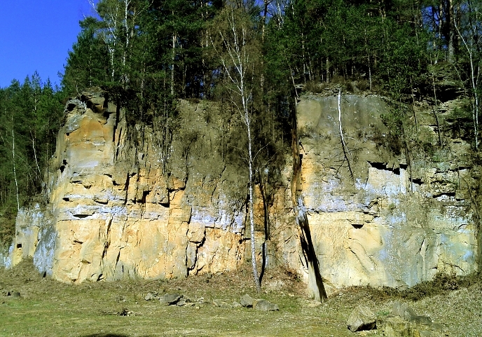
Luxembourgish sandstone has been deposited 210 mya in the form of sandwalls. The sandy material has been transported by rivers in the northeast. Later on, the depositions have been lifted to their present position. Overlaying younger stones have been carried away, while the Sauer was forming in the underground. This sandstone walls can save a lot of water which is why they are one of our main groundwater reservoirs.
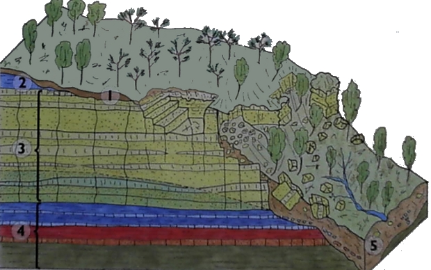
1) Earth 2) Marlstone 3) Luxembourgish sandstone 4) Depositions of marl and clay with chalk and sandstone layers 5) Rubble of timeworn rock
Around 35 % of the annual rainfall seeps away very fast on on the sand soil and in the pores of the sandstone and are that way part of the groundwater reformation. The rest of the rainfall(around 55%) evaporates or flows on the upper layer (around 10%). The groundwater congests on the marl, which is quite water resistant, and flows out of sources after a certain delay. It has a good quality as these layers work as filters. Because of the solution of the carbonaceous binder it is rich of calcium, magnesium and hydrogenecarbonate. The Luxembourgian sandstone often creates steep rock walls, which can be covered with scree, because of its clefting. The groundwater congests on the marl on the base of the sandstone. Spring water can undermine the sandstone which can lead to its instability and make it slip down in the valley. The changing of hard and soft socketformations created a gradual layer landscape.
On the landscape of the Luxembourgian sandstone, you can find typical soils and plants on the tops and slopes. On the hard rocks and scree, brown earth is formed by weathering and soil forming processes. The soils don't have enough nutrients for agricultural purposes.
The stone quarries were a very important economic factor in the east of Luxembourg and offered many jobs(stone mason, stone crasher, smiths,...). These stones were also exported, up to the UK and India.
The stone quarries of Beaufort and Reisdorf were operating from 1835 to 1957.
To successfully log the cache:
-send me a message with the kinds of trees you find in such areas and why they grow there. You don't have to wait for my answer, if something is wrong, I'll reply you.
optionally
-and make pictures of you with your Gps:
--in front of the quarry(Steinbruch)
--at the Station 6 area
Deutsch:
Der luxemburgische Sandstein wurde vor etwa 210 Mio. Jahren in Form von Sandwällen abgelagert. Das sandige Material wurde von Flüssen im Nordosten herantransportiert. Später wurden die Ablagerungen in ihre heutige Position gehoben. Überlagernde jüngere Gesteine wurden abgetragen, während sich die Sauer in den Untergrund einschnitt. In seinen Poren und Klüften kann der Sandstein viel Wasser speichern, so dass er zu den wichtigsten Grundwasserspeichern Luxemburgs gehört.
Etwa 35% des jährlichen Niederschlags versickern auf dem Sandboden und in den Klüften und Poren des Sansdsteins schnell und tragen somit zur Grundwasserneubildung bei. Der Rest des Niederschlages verdunstet (etwa 55%) oder fließt oberflächlich ab (etwa 10%). Das Grundwasser staut sich auf den gering wasserdurchlässigen Mergeln und tritt mit einer Verzögerung an Quellen wieder aus. Der Luxemburger Sandstein liefert etwa 60% des Trinkwassers in Luxemburg. Aufgrund der hohen Filterkapazität ist es von guter Qualität. Aufgrund der Lösung des karbonatischen Bindemittels hat es hohe Kalzium-, Magnesium- und Hydrogenkarbonat-Anteile. Der Luxemburger Sandstein bildet wegen seiner Klüftigkeit oft steile Felswände, die von Hangschutt bedeckt sein können. Das Grundwasser staut sich auf den Mergeln an der Basis des Sandsteins. Quellwasser kann den Sandstein unterhöhlen, er wird dann instabil und stürzt ins Tal. Durch die Abfolge von harten und weichen Sockelbildnern ist eine Schichtstufenlandschaft entstanden.
In der Landschaft des Luxemburger Sandsteins treten auf den Plateaus und an den Hängen typische Böden und Pflanzen auf, Aus dem Festgestein und dem Hangschutt entsteht durch Verwitterung und bodenbildende Prozesse hauptsächlich Braunerde. Die Böden sind nährstoffarm und mit Wald bestanden. Die landwirtschaftliche Nutzung lohnt sich nicht.
Die Steinbrüche waren ein sehr wichtiger wirtschaftlicher Faktor im Osten des Landes und schaffte viele Arbeitsplätze(Steinbrecher, Steinhauer, Schmiede, …) Diese Steine wurden bis nach Grossbritannien und Indien exportiert. Die Steinbrüche in Beaufort und Reisdorf waren von 1835 bis 1957 in Betrieb.
Um diesen Cache zu loggen müsst ihr:
-mir eine Nachricht schicken mit den Baumarten die hier vorkommen und warum diese gerade dort vorkommen. Ihr braucht nicht auf meine Antwort zu warten, falls etwas nicht ok sein sollte, antworte ich euch.
optional
-ein Photo mit dir und deinem Gps beim Log hochladen:
--vor dem Steinbruch
--im Bereich von Station 6
Additional Hints
(No hints available.)