Coal
A driving force in the development of southern West Virginia was the discovery of coal in the late 1800s. The bituminous coal found in this region is a type of sedimentary rock formed when organic elements like trees and plants are compressed and heated over long periods of time. After being mined from the seams (deposits) found in area mountains and hillsides, the coal is cleaned, sized, and transported for use by power plants, steel mills, and other industrial users.
New River Gorge
Despite its name, the New River is considered to be one of the oldest rivers on the planet and predates the uplifting that formed the ancient Appalachian Mountains. The only non-tidal river to cross the Appalachians, it has its headwaters in western North Carolina near Boone. As it flows northward, it enters Virginia and passes through the Radford and Blacksburg areas before turning northwest. It enters the 53-mile New River Gorge, its most prominent section, at Hinton. Here, cliffs up that are over 1,200 feet high in places separate the plateau that makes up much of Raleigh and Fayette Counties from the river below.
Due to the forbidding terrain, the New River Gorge area was largely unsettled until after the Civil War. The 1873 completion of the Chesapeake & Ohio Railway through the Gorge opened the area for development. Coal seams were quickly discovered high on the Gorge walls and along the New’s tributaries. Mining communities quickly developed to extract the resources, a process which lasted through the 1950s and 1960s by which time most coal reserves had been mined out.
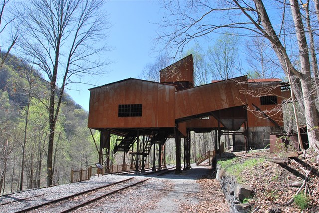
Nuttallburg
Located just downstream of where Short Creek cascades down the north wall of the Gorge, Nuttallburg was one of the first towns along the New River when developed in 1870. It exported its first coal shortly after the railroad opened in 1870. The town reached its apex from 1920-1928 when it was managed by Henry Ford’s enterprise which greatly modernized the works and constructed the tipple and conveyor that remain today. The mine closed in 1958 after 85 years of extracting New River coal.
The National Park Service acquired Nuttallburg in 1998 from the descendants of John Nuttall, the town’s founder. Stabilization and restoration work from 2005-2011 saved the remaining structures and added the visitor amenities found today.
Claiming Credit for this Earthcache
To complete this EarthCache, you’ll need to visit the NPS-developed area near Nuttallburg including the tipple/conveyor and information displays.
E-mail your answers to the cache owner. Do not post them in your log.
If visiting Nuttallburg bottom (posted coordinates)
- What is coke made from? What makes coke more desirable than its source material?
- How much vertical elevation difference do you think the mine conveyor covers? For perspective, the Gorge wall is about 1,100-feet high here. The silo part of the tipple is 72-feet from the top to the ground beneath it.
- How did the terrain in New River Gorge affect the development of the town and housing for employees?
- Double Z Rapids, one of the largest in the Gorge, is in the New River in the area between the main parking lot and the tipple. Normally, many large rocks are visible here in the river (see satellite image). How did the river compare when you visited?
If visiting the headhouse (alternate due to road closures)
- What coal seam was mined here and how thick was it?
- What types of rock are in the stone roof, above the coal that was mined
- Approximately how wide is the drift mouth (main portal) of the mine?
Important Visitor Notes
The normal access route via Keeneys Creek Road is expected to be closed for all of 2019 due to a flood damage. Visitors may alternately make a strenuous hike in via Headhouse Trail (waypoint below) to the Headhouse in the meantime. Visit New River Gorge National River's Alerts & Conditions page for updates.
To access this cache, take CR 82 (Lansing-Edmond Road) from US 19 or US 60 to Winona. (Coming in from US 60 is much faster.) CR 85/2 (Keeneys Creek Road) provides access to Nuttallburg. Some maps incorrectly show Beauty Mountain Road intersecting Keeneys Creek Road south of Winona, but this road is no longer passable. Go through Winona.
Keeneys Creek Road is narrow and 1-lane wide in many places. It’s also gravel for portions of the trip. The road is readily passable in a passenger car but use caution due to blind curves.
Winter: Nuttallburg is open year-round, but expect Keeneys Creek Road to be icy during the winter due to limited sunlight because of the deep gorge walls. It may be best to wait for an extended warm period.