Dieser EarthCache hat keinen Container, noch gibt es eine spezifische Informationstafel.
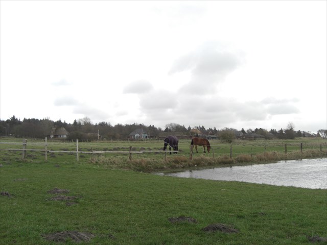
Die Koordinaten führen dich zu einem Ort, an dem du dich erholen und den weiteren Besuch planen kannst.
This EarthCache has no container and you can’t find a specific information panel, either.
The coordinates get you to a place where you can rest and plan further steps of your visit.
(Die Aufgaben befinden sich am Anfang des Textes, um eventuelle Anzeigeprobleme einiger GPS-Geräte bei langen Texten vorzubeugen.)
Aufgaben:
- ????? – Wie viel Meter bewegten sich die Gletscher der Saale-Kaltzeit pro Jahr voran?
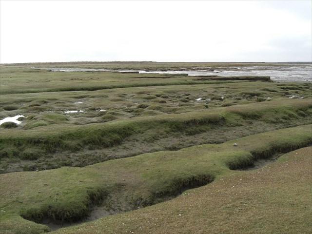
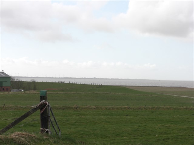
- Wenn du auf der kleinen Seebrücke stehst und auf das Wasser (oder Watt) siehst, kannst du von dort aus einen Fjord sehen? Begründe deine Meinung.
- Auf der anderen Seite des Wassers/Watts ist Land, das auch durch die Saale-Kaltzeit beeinflusst wurde. Ist das eine Hallig? Begründe deine Meinung.
- Auf einer weiteren Infotafel stehen die Höhe des „Schobüller Berges“ und die Größe des Landschaftsschutzgebiets. Nenne beides.
(The tasks are at the beginning of the script to prevent optional problems of some GPS-devices in showing the whole text below.)
Tasks:
- ????? – How many meters a year did the glaciers of the Saale Glacial Period move?
- If you stand on the pier and look at the water (or mudflat), do you think this is a fjord? Please, give a reason for your opinion.
- At the other side of the water/mudflat is land that was infected by the Saale Glacial Period. Is it a “Hallig”? Please, give a reason for your opinion.
- On another info panel you can find the height of the “Schobüller Berg” [Schobüll mountain] and what is the size of the “Landschaftsschutzgebiet” [nature preserve] surrounding it?
[Well, the last question is a bit more challenging for Non-German speakers – but you make it...]
Nimm dir Zeit und setze dich ein wenig. Mache optional ein Foto von dir und/oder deinem GPS-Gerät und dem Watt/Meer von den Koordinaten aus. (Siehst du auf der anderen Seite den hohen Turm? Das ist der Getreideturm von Süderhafen auf Nordstrand.) Schicke die Lösungen aller Aufgaben an die E-Mailadresse im Hint/Hinweis. Du kannst sofort loggen (und bist herzlich eingeladen dies mit einem Foto zu tun). Ich melde mich, wenn etwas nicht stimmt. Schön, dass du in Schobüll warst. Genieße das Meer auf der einen und Schobüll auf der anderen Seite noch ein wenig.
Please, take your time, sit down and relax. Make an optional photo of you and/or your GPS-devise and the tideland/sea from the coordinates. (Can you see the white, long tower on the other side? That’s the grain elevator of “Süderhafen” of “Nordstrand”.) Please send the answers to all the tasks to the email-address shown in the hint. You can log directly (and you are invited to post a picture, too). I get in contact with you if there is something wrong. Thank you for visiting Schobüll. Please, enjoy the sea on the one side and Schobüll on the other side a little longer.
Hintergrundinformationen / background information
Vor gerade einmal 200.000 Jahren machten sich jede Menge Gletscher auf den Weg von Finnland, Schweden und Norwegen, um uns – im schönen Schleswig-Holstein – zu überrollen. Und „Bämm“ waren sie da, die Gletscher der vorletzten Eiszeit, dem Saale-Glazial.
Mit atemberaubendem Tempo von etwa ????? Metern pro Jahr kämpften sich die bis zu drei Kilometer hohen Eisriesen bis zu uns vor. Weniger wegen der Anstrengung, sondern vielmehr aufgrund der milderen Witterung verloren sie viel Höhe und Masse bis zu uns. Doch anders als in der Weichsel-Kaltzeit (Weichsel-Glazial – vor 80.000 bis 15.000 Jahren), die im Nord-Süd-Verlauf in der „Mitte“ von Schleswig-Holstein zum Stehen kam, sausten die Saale-Eiszeit-Gletscher locker über uns hinweg und noch weiter gen Westen und Süden.
It was not more time than 200.000 years ago that a whole bunch of glaciers made their way from Finland, Sweden and Norway to overrun us – in our beautiful Schleswig-Holstein. “Wham Bam” and they were here – the glaciers of the second last ice age, the Saale Glacial Period.
With a breathtaking speed of around ????? meters a year the up to three kilometers high ice giants forge ahead to us. Not because of the struggle rather than the milder atmospheric conditions they lost height and weight when they reached us. It was not as in the Weichsel cold stage (Weichsel Glacial Period – 80.000 to 15.000 years ago) where the glaciers stopped in a north-south-pathway in the “middle” of Schleswig-Holstein. The Saale-Ice-Age-Glaciers swept nonchalantly across us - and further west and south.
Durch die Erfindung der Langsamkeit konnten erst riesige Steine und Geröllmassen in den Gletschern mitgeschoben werden. Die Eismassen zerdrückten alles unter sich und konnten sogar an Gebirgen „knabbern“. Wie gewaltig die Kraft war, kann man heute noch an den Fjells, Fjorden und Schären in Skandinavien sehen. Sie sind durch die schiebenden und schürfenden Gletscher entstanden, die tiefe Furchen in die Küsten schnitten und den ganzen Kram mit sich schoben.
So ein Gletscher wog verdammt viel. Drei Kilometer Eis sind etwa 3000 Tonnen Druck auf einen Quadratmeter. Das heißt umgerechnet, dass auf eine gemütliche Matratze, auf der man nachts schläft, etwa 6000 Autos gestapelt werden müssten, um den Druck der Gletscher zu erreichen. Das ist selbst für unsere Mutter Erde ganz ordentlich – gerade, wenn dieses Gewicht, auf ganz Nordeuropa, für 50.000 – 75.000 Jahre, lag.
Because of the invention of slowness the gigantic amount of stones, boulders and debris could have been pushed to us. The glacial ice sheets crumpled everything and could even “nibble” at mountain ranges. How tremendous this force was could be seen at the Scandinavian fjells, fjords and skerries today. They were formed by the shoving and digging glaciers. Deep gouges in the coastline were cut by them and they took all the stuff with them to us.
These big lumps of ice were mighty heavy. Three kilometers big ice means about 3000 tons pressure on one square meter. Converted to the surface of a snuggery mattress (you usually sleep on) around 6000 cars must be stapled on it to get the pressure of the glaciers. Even for mother earth it was well stacked – especially because this weight was all over northern Europe for 50.000 to 75.000 years.
Noch immer erholt sich unser Norden von der unvorstellbaren Last des Eises (der beiden letzten Eiszeiten). Wie ein Korken, den man unter Wasser gedrückt hat und nun wieder loslässt, so „ploppt“ die Erde auch in Schleswig-Holstein wieder hoch – natürlich nach geologischen Maßstäben. Im Jahr sind das in Schobüll etwa 10 Millimeter. In Skandinavien können es bis zu 100 Millimeter sein.
Still now our North recovers because of this incredible burden of the ice (of the two last ice ages). Like a bottle cork pressed under water and released again, the earth “pops” up – well, in geological norms. It’s about 10 millimeters in Schobüll every year. In Scandinavia it could be up to 100 millimeters.
Auch, wenn es sich zerstörerisch anhört, aber erst durch die Saale-Kaltzeit bekommen wir in Schleswig-Holstein keine nassen Füße mehr. Denn erst mit dem gigantischen Material an Erden, Sanden, Steinen und Geröll, die die Gletscher hierher brachten, konnte Schleswig-Holstein aus dem Meer entstehen. Das alles verdanken wir dem Salz. Nein, nicht dem im Meer, denn das Meer war zur Eiszeit ohnehin nicht da. Das Meerwasser war in großen Teilen in den Gletschern gebunden und der Meeresspiegel um etwa 100 Meter unter dem heutigen, sodass man tatsächlich nach Großbritannien gehen konnte. Nein, gemeint ist die Steinsalzschicht, die im Tertiär (vor 65 Millionen Jahren, also vor weeeesentlich längerer Zeit als die beiden Kaltzeiten) aufquoll und die darüber liegenden Gesteinsschichten nach oben presste. Ob der Helgoländer Buntsandstein, der Seegeberger Kalkberg, die Liether roten Tone oder die Kreide in Lägerdorf, alle Erhöhungen stellten Hindernisse für die Gletscher dar, an denen sie ihr Material „verloren“ oder zurück ließen. Fast wie die Inseln, die vor Dubai entstanden sind, haben die Gletscher so viel Material hier gelassen, dass das Land einige Meter hoch mit Geröll aus 1000 Kilometern und mehr Entfernung aufgeschüttet wurde.
Even if it sounds destructive, only because of the Saale Glacial Period we – in Schleswig-Holstein – don’t get wet feet anymore. Only the gigantic material of earths, sands, stones, boulders and debris the glaciers brought here was the reason Schleswig-Holstein arose out of the sea. At least we owe our land the salt; No, not the salt out of the sea. The sea wasn’t present anyhow in the ice ages. The sea water was a great extend part of the glaciers around the world and the sea level was about 100 meters lower than today. It was literally possible to walk to Great Britain (but don’t let them know – otherwise they use even more energy to heat up the atmosphere, for never getting an ice age again). The halite layer was meant which swell up and pressed the other stone layers to the top. (That was 65 million years ago in the Tertiary – so waaaay back time before the both cold stages.) Whether red sandstone of Helgoland, the limestone hill of Seegeberg, the red clay of Liether or the cretaceous layer of Lägerdorf all these hills represented barriers for the glaciers. So they “lost” material or they just left it behind. It was a bit like the islands in Dubai. The glaciers left so much material that the land elevated a couple of meters because of the coarse gravel coming here from more than 1000 kilometers.
Die Aufschüttungen des Saale-Glazials, die heute noch zu sehen sind („anstehen“), nennen sich Altmoränen. Dadurch, dass die Weichsel-Eiszeit nie an die Westküste kam, kann man die Altmoränen in Schleswig-Holstein nur noch hier finden. Der östliche Teil wurde von den Gletschern und dem Material der Saale-Eiszeit überformt und oftmals verdeckt. Doch auch an der Westküste haben diese Altmoränen nicht mehr die alte Form. Die riesigen Schmelzwasserflächen und -flüsse der – wohlgemerkt wesentlich kleineren – Gletscher der letzten Eiszeit fraßen sich durch die Altmoränen, die wie Inseln zurück blieben.
This „heap up“ of the Saale Glacial Period can still be seen today (“outcrop”) and is called “Altmoränen” (“old moraines”). Thus the Weichsel ice age never came to the west-coasts of Germany so; it’s the only spot for “old moraines”. The eastern part of Schleswig-Holstein was affected and covered by the Saale cold stage. But even at the shore of the west-coast the “old moraines” don’t have their given shape anymore. The gigantic melting water beds and flows of the (even smaller) glaciers of the last ice age ate themselves through the “old moraines” and left something like inland-islands.
 Doch diese Altmoränen waren noch an ganz anderer Stelle die „Felsen in der Brandung“. Quasi alle nordfriesische Inseln (nicht Halligen) existieren heute nur, da Altmoränenkerne das „Fundament“ für die Inseln bilden. Auf Sylt sind es zum Beispiel drei Geestkerne, die die Insel im Innersten zusammenhalten. Damit sind wir auch beim geläufigeren Namen für Altmoränen angelangt. Sie werden nämlich auch „Hohe Geest“ genannt, da sie im Gegensatz zum Marschboden, der aus dem Meer aufgespült wurde, „hoch“ über das übrige Gelände herausragen. Man braucht sich nur die Namen auf der Landkarte ansehen und findet schnell die „Geest-Inseln“ auf dem Festland. Alte Bezeichnungen für Inseln sind „Holm“ und „Horst“. Somit kann man schon fast mit Sicherheit sagen, dass Stapelholm oder Grevenhorst mit einer Hohen Geest in Verbindung gebracht werden kann.
Hier in Schobüll gibt es nun eine einmalige Besonderheit an der schleswig-holsteinischen Küste, die auch noch positive Auswirkungen für die Bewohner (und negative Auswirkungen auf die Grundstückpreise, die sehr hoch sind) hat. Schobüll liegt auf einer aufgeschobenen Altmoräne (eine sogenannte „Stauchmoräne“), also auf der Hohen Geest, die genau hier ins Meer fällt. Durch die relative Höhe der Geestinsel (auf dem Festland) ist Schobüll der einzige Ort an der friesischen Nordseeküste, der nicht eingedeicht werden musste. Sanft steigt der „Schobüller Berg“ vom Wasser auf, um dann tatsächlich merkbar hügelig im Hinterland zu werden. Der Ort liegt also auf einer natürlichen „Riesenwarft“ und kann noch lange, auch großen Sturmfluten, trotzen, da die „Hohe Geest“ hier wesentlich höher als der höchste Deich ist. Und dabei hat man einen so schönen Blick über das Wattenmeer – ohne deichverstellten Blick.
These „old moraines“ were also a „firm of a rock“ elsewhere. All the North Friesian islands only exist because of the old moraine cores acting as a “fundament” to the islands. (This isn’t essential for the “Halligen”.) On the island „Sylt“ you can find three „Geestkerne“ (Geest cores) holding the island together. [“Geest” is the German word for the coastal “moorlands” of sandy soil] There we are with the more common used term for the “old moraines”. They are called “Hohe Geest” (high Geest) because they rise highly over the surrounding marshlands. You just need to pick a few toponymy names from the map and you can find “Geest islands” right away on the inland. The old German nomenclature for islands was “Holm” or “Horst”. So, you can nearly be certain that places like “Stapelholm” or “Grevenhorst” are connected to “high Geest”. Here, in Schobüll, you can find a special characteristic in Schleswig-Holstein. Schobüll lies on a shoved moraine which falls into sea. Because of the relative height of this “Geest island” (on inland) Schobüll is the only place at the Frisian North Sea coastline that isn’t dyked – and there is no need to. The “Schobüll mountain” gently rises out of the tidal flat and becomes wavy in hinterland. The whole village lies on a gigantic natural “Warft” (“dwelling mound”). Even though the highest surges hit the land this “high Geest” can defy them. This “high Geest” is much higher than the highest dykes. And you have such a nice view atop the sea – without the annoying dykes  .
.