Le dévonien
Le Dévonien est un système géologique s’étendant de 416 ± 2,8 à 359,2 ± 2,5 millions d’années. Il est suivi par le Carbonifère et précédé par le Silurien. Le Dévonien est nommé d’après le Devonshire en Angleterre où les affleurements de couches datant de cette époque sont communs.
Durant le Dévonien les poissons évoluent vers des formes qui vont conduire aux premiers tétrapodes puis aux amphibiens. Les insectes et araignées commencent à coloniser les habitats terrestres. Les premiers Progymnospermes s'étendent sur les terres en formant des forêts. Dans les océans les requins primitifs sont plus nombreux que pendant l'Ordovicien supérieur ou le Silurien. De nouvelles formes d'Ammonites et de trilobites apparaissent. Les brachiopodes sont communs ainsi que les grands récifs coralliens.
La paléogéographie est dominée par le supercontinent Gondwana dans l'hémisphère sud et de plus petits continents au nord, Siberia et de Laurussia, constitués de l'Amérique du Nord et d'une partie de l'Europe entre les deux.
The Devonian
The Devonian is a geologic period and system of the Paleozoic Era spanning from the end of the Silurian Period, about 416.0 ± 2.8 Mya (million years ago), to the beginning of the Carboniferous Period, about 359.2 ± 2.5 Mya. It is named after Devon, England, where rocks from this period were first studied. The Devonian period experienced the first significant adaptive radiation of terrestrial life. The first seed-bearing plants spread across dry land. Since large vertebrate terrestrial herbivores had not yet appeared, they formed extensive forests which covered the continents. The first ray finned and lobe-finned bony fish also appeared. The pectoral and pelvic fins of lobe-finned fish evolved into legs as they started to walk on land as tetrapods around 397 million years ago. They would become the ancestors to early amphibians. Various terrestrial arthropods also became well-established. In the oceans, primitive sharks became more numerous than in the Silurian and the late Ordovician. The first ammonite mollusks appeared. Trilobites, the mollusc-like brachiopods, as well as great coral reefs were still common. The Late Devonian extinction severely affected marine life. The paleogeography was dominated by the supercontinent of Gondwana to the south, the continent of Siberia to the north, and the early formation of the small supercontinent of Euramerica in between.
Les schistes
Le schiste est une roche reconnaissable pour son aspect feuilleté. Le schiste se débite en plaque fine, voir en feuillet rocheux.
Le terme de schiste regroupe des roches sédimentaires argileuses ou des roches métamorphiques. Dans le premier cas, il y a possibilité d'y trouver des hydrocarbures (les fameux gaz de schistes) et dans l'autre cas il ne peut y en avoir car la température au moment de la formation des roches métamorphiques a détruit toutes molécules d'éventuels hydrocarbures.
Shale
Shale rock is recognizable for its laminated appearance. The shale is sold in thin plate, sheet rock in view.
The term includes shale or argillaceous sedimentary rocks of the metamorphic rocks. In the first case, there is the possibility of finding hydrocarbons (the famous shale gas) and in either case there can not have because the temperature at the time of formation of metamorphic rocks destroyed all molecules hydrocarbon potential.
La kersantite, la roche bretonne
La kersantite, ou pierre de Kersanton, est une roche magmatique filonienne, de composition proche du granite, et présentant un intérêt certain pour la sculpture, car elle allie la facilité à être sculptée à la résistance au temps et aux intempéries.
La kersantite tire son nom du hameau de Kersanton (commune de Loperhet) situé à proximité de la rade de Brest, à environ 15 km au sud-est de la ville de Brest. La carrière du Rhunvras, à l'Hôpital-Camfrout exploite aussi cette roche. On en trouve aussi des gisements à Penallen en Plougastel-Daoulas, à Penavoas au Faou, à Kerascoët et Tréoc en L'Hôpital-Camfrout, à Kersanton en Loperhet, à Moulin-Mer et Le Roz en Logonna-Daoulas, etc..., tous ces gisements étant proches de la Rade de Brest. D'autres gisements se trouvent un peu plus en Bretagne intérieure comme au Moulin du Crann en Lennon, Guervénec en Rumengol, Resthervé en Poullaouen, Saint-Roch en Carhaix ou aux alentours du Tréhou.
C'est, en première analyse, presque la seule pierre (un autre exemple, moins connu existe toutefois, la sizunite dont le nom provient du Cap Sizun et qui est une roche proche de la kersantite) dont le nom officiel soit directement issu d'un toponyme de Bretagne. Roche unique au monde, elle fait partie intégrante du patrimoine géologique mondial.
The kersantite, the Breton rock
kersantite or Kersanton stone is an igneous rock vein, near the granite composition, and of significant interest for sculpture, as it combines the ease to be carved resistance to time and weather.
The kersantite named after the hamlet of Kersanton (municipality of Loperhet) located near the harbor of Brest, about 15 km southeast of the city of Brest. The career of Rhunvras, Hospital-Camfrout also operates the rock. They are also found in deposits in Penallen Plougastel-Daoulas to Penavoas to Faou to Kerascoët and Tréoc Camfrout-in Hospital, to Kersanton in Loperhet at Moulin-Mer and Le Roz in Logonna-Daoulas, etc. ... all these deposits are close to the Bay of Brest. Other deposits are located a little further inland Brittany as Crann in the Mill of Lennon, in Guervénec Rumengol, Resthervé in Poullaouen, Saint-Roch in Carhaix or about Tréhou.
This is an initial analysis, almost the only stone (another example, are less known, however, the sizunite whose name comes from the Cape Sizun and is a rock near the kersantite) whose official name is directly derived from a place name to Britain. Roche unique, it is part of the geological heritage.
Le fillon de Kérascoet
Au sud du port, sur la grève accessible à marée basse, nous pouvons remarquer sur les falaises d'une dizaine de mètres de haut.
Dans cette falaise composée de schistes du dévoniens, nous pouvons observer une lame de kersantite. Cette lame est parallèle aux strates de schistes. Cette lame peut être rapprochée du faciès de Rosmorduc que l'on peut apercevoir de l'autre côté de la rivière.
Sur l'estran, le kersantite se débite en boule sous l'effet de l'érosion. D'un diamètre d'une dizaine de centimètre, les boules présentes en série résultent d'une altération de la roche qui progresse de manière concentrique à partir du réseau de diaclases.
Ne pas ramasser de roches car le milieu est fragile
The fillon of Kerascoët
South of the port, on the beach accessible at low tide, we can see the cliffs of about ten meters high.
This cliff composed of Devonian shale, we can see a blade kersantite. This blade is parallel to the layers of shale. This blade can be related facies Rosmorduc that can be seen on the other side of the river.
On the foreshore, the kersantite is sold in a ball under the effect of erosion. With a diameter of ten centimeters, the balls in these series result from alteration of the rock that progresses concentrically from the network of joints.
Do not pick up rocks because the environment is fragile
La Earth Cache
Pour valider cette Earth Cache vous devez m'envoyer un e-mail avec les réponses aux questions suivantes.
- Quelle est la direction de l'inclinaison de la lame de kersantite ?
- Quelle est l'épaisseur de la lame ?
- Prenez une photo d'une ou plusieurs boules de kersantite sur l'estran, avec votre gps ou votre stylo ou tout autre objet de géocaching permettant de donner l'échelle. (voir photo 1). Cette photo est optionnelle.
- Mesurer avec une précision de +/- 2 cm la distance entre les deux diaclases comme indiqué par la flèche jaune sur la photo 2.
Nous apprécierons si vos logs sont accompagné de photos prises sur place !
The Earth cache
To validate this Earth Cache you must send me an email with the following questions.
- What is the direction of the inclination of the blade of kersantite
- What is the thickness of the blade?
- Take a picture of one or more balls kersantite on the foreshore, with your GPS or your pen or other object of geocaching to give scale. (See photo 1) This task is optional.
- Measuring with an accuracy of + / - 2 cm distance between the two joints as indicated by the yellow arrow in picture 2.
We will appreciate if your logs are accompanied by photographs taken on site
Photo 1 : 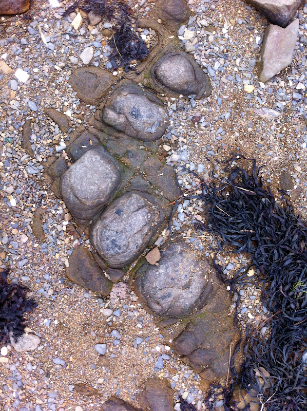
Photo 2 :