V rámci realizace plánu společných zařízení z Komplexní pozemkové úpravy Chomýž vybudoval v roce 2011 Pozemkový úřad Kroměříž za využití prostředku z Programu rozvoje venkova ČR na období 2007 – 2013 stavbu polní cesty Chomýž - Jankovice včetně přemostění toku Zhrty.
Within the implementation plan of the joint facilities Comprehensive landscaping the village of Chomyz built in 2011, the Land Office Kromeriz by using funds from the Rural Development Programme of the Czech Republic from 2007 to 2013 construction field trips Chomyz - Jankovice including bridge over the Zhrta.
Potok s podivným názvem Zhrta je levostranným přítokem říčky Rusavy, do které se vlévá v obci Jankovice. Pramení pod západními výběžky Hostýnských vrchů mezi Poschlou (629 m.n.m.) a Lysinou (597 m.n.m.). Název je natolik zvláštní a například pro Francouze zcela nevyslovitelný, že jsem neodolal a použil jej v názvu této kešky. Na starších mapách Zhrtu ale nehledejte, najdete jen potok s názvem Dědinka.
Creek with a strange name Zhrta is the left tributary of the river Rusava, which empties into the village of Jankovice. It springs below the western foothills of the Hostýn´s hill Poschla (629 m) and Lysina (597 m). The name is so special and such for the French completely unpronounceable, that I could not resist and used it in the name of the cache. But do not try to look for Zhrta in the older maps, you'll find the own creek, so called Dedinka.
Vlastní stavba řeší rekonstrukci jednopruhové hlavní polní cesty oznacené v KPÚ Chomýž „C1" se začátkem úpravy na hranici zastaveného území obce Chomýž v návaznosti na zpěvnenou místní komunikaci (N 49° 21.635', E 17° 38.390' – Stage 1 – hodnoty C, D) a s koncem úpravy na hranici zastaveného území obce Jankovice, opět s navázáním na zpevněnou místní komunikaci (N 49° 21.430', E 17° 37.620' – Stage 2 – hodnoty A, B, E, F). Délka úpravy je 1,05 km, kategorie P5,0/30 s pojízdným pásem o šířce 4,00 m se živičnou konstrukcí a navazujícími krajnicemi šířky 2 x 0,50 m. V trase byly realizovány celkem 4 výhybny s celkovou šířkou 5,50 m a 7 sjezdu na polní cesty nižšího rádu umožnující přímý přístup na okolní pozemky. Výškově je komunikace mírně „vytažena nad terén" a její odvodnění je řešeno příčným spádováním do příkopu. Na začátku a na konci úpravy jsou provedeny zvýšené zpomalovací prahy s osvětlením. Po komunikaci vede trasa 55 km dlouhé značené cyklostezky č. 5033 z Kroměříže do Hustopečí nad Bečvou, spojující dálkové cyklotrasy č. 47 (Kroměříž) a č. 5 (Hustopeče nad Bečvou).
This building addresses the reconstruction of one stripe main dirt track marked in the Comprehensive landscaping of Chomyz „C1“ begins adjustments on the edge of the built village Chomyz following the paved local road (N 49 ° 21.635 'E 17 ° 38.390'– Stage 1 – values C, D) and the end of adjustments on the boundary of the built village Jankovice, again building on local paved road (N 49 ° 21.430 'E 17 ° 37.620'– Stage 2 – values A, B, E, F). Length of the reconstruction is 1,05 km, category is P5,0/30 with belt width 4.00 m and subsequent construction of bituminous roadside 2 x 0.50 m width. In the route are realized altogether of 4 passing bays with a altogether width of 5.50 m and 7 exits on field trips of lower order allowing direct access to the surrounding land. Height communication is slightly "pulled above ground" and its drainage is dealt with in with slope lateral ditches. At the beginning and the end adjustments are made speed bumps with lighting. On the communication route runs 55 km long marked trails No. 5033 from Kromeriz to Hustopece nad Becvou, connecting long cycle trails No. 47 (Kromeriz) and No. 5 (Hustopece nad Becvou).
Pro srovnání přikládám stav komunikace před a po vybudování.
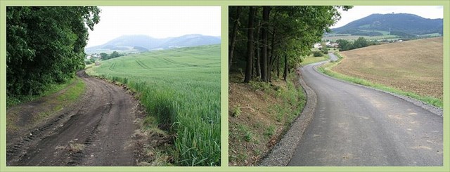
For comparison, I attach the communication status before and after the construction.
Protože stávající přemostění toku Zhrty bylo v nevyhovujícím stavu, byl původní most zdemolován a postaven nový monolitický, železobetonový objekt. Volná šířka nového mostu je 6,10 m, délka včetně opěr 14,924 m. Po obou stranách mostu jsou odrazné pruhy (římsy) šíře 0,75 m, čistá šířka průjezdného profilu je 5,10 m. Jako bezpečnostní zařízení slouží ocelové mostní zábradlí.
Because the existing bridge over the Zhrta was in unsatisfactory condition, original bridge was demolished and built a new monolithic, reinforced concrete bridge. Open width a new bridge is 6.10 m, length of abutments including 14,924 m. On both sides of the bridge are reflective stripes (ledge), width 0.75 m, clear width of the clearance profile is 5.10 m. As a safety device used steel bridge railing.
Spolu s rekonstrukcí mostu je řešena i úprava koryta. Ta převádí stávající profil na návodní a povodní straně mostu do lichobežníkového profilu u mostu. Tyto přechodové úseky jsou dlážděny z lomového kamene na betonovou desku. Zpevněné úseky stávajícího koryta jsou řešeny záhozem lomovým kamenem s urovnáním líce.
Along with the reconstruction of the bridge is designed and modification channel. Modification channel is converts an existing profile on the upstream side of the bridge and flood side of the bridge to the trapezoidal profile of the bridge. These transition areas are paved with stone from the quarry to the concrete slab. Paved sections of the existing channel are designed to backfill quarry stone front of settlement faces.
Opět pro srovnání přikládám stav přemostění před a po vybudování.

Again, for comparison, I attach the communication status before and after the construction.
Pro nalezení keše musíte zjistit souřadnice
N 49° 21.ABC', E 17° 37.DEF'
A - poslední číslice z opatření na informační tabuli u mostu
B - celkový počet drenážních výpustí mostní konstrukce
C - polovina prvního malého čísla na modré tabulce na plotě
D - součet malých čísel na modré tabulce na plotě
E - počet vnitřních svislých tyčí prvního severovýchodního pole zábradlí
F - počet čísel na informační tabuli u mostu
To find the cache you need to find coordinates
N 49° 21.ABC', E 17° 37.DEF'
A - the last digit of the measures (opatřeni) on the information board
B - total number of drainage outfalls for bridge construction
C - half of the small numbers on the blue table on the fence
D - the sum of the small numbers on the blue table on the fence
E - number of internal vertical bars the first railing Northeast field
F - the total number of digits on the information board at the Bridge
Další české jazykové lahůdky bez samohlásek typu Zhrta
For more Czech language delicacies with possible absence of vowels type Zhrta
Strč prst skrz krk. Stick your finger through your throat.
Vlk zmrzl, zhltl hrst zrn. The wolf froze, he swallowed a handful of grains.
Smrž pln skvrn zvlhl z mlh. Morel full of stains got wet from the fog.