The Bluffs of Whidbey EarthCache
-
Difficulty:
-

-
Terrain:
-

Size:  (other)
Please note Use of geocaching.com services is subject to the terms and conditions
in our disclaimer.
An Earthcache located along the Ebey Bluff Trail within Ebey's Landing National Historic Reserve.
Location & Points of Interest
-----------------------------------------------------------------------------------------------------------
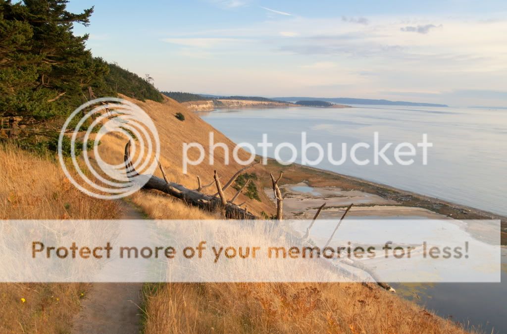
The western shore of Whidbey Island offers one of the most beautiful coastlines in the Puget Sound. High above Admiralty Inlet from atop Whidbey’s famous bluffs, one will find sweeping views of both mountains and sea. Cruise ships, tankers, and even Navy submarines sail through here in the shadow of the Olympic mountain range, which dominates the western horizon. To the north, Vancouver Island and the San Juans can be seen out in the distance across the Strait of Juan de Fuca. Mount Rainier rises majestically to the south. On the clearest of days, downtown Seattle is visible from here, nearly 45 miles away. To the east, Mount Baker and the Cascade mountain range rise above historic farmlands and prairies. It’s no wonder why the Ebey Bluff Trail is among the most popular walks in the region.
Geology of Coastal Bluffs
-----------------------------------------------------------------------------------------------------------
Bluffs are widespread landforms and are found all over the world, occurring along approximately 80 percent of the Earth’s coast and more than 60 percent of the Puget Sound shores. The entire Ebey Bluff formation spans from Fort Casey to a point just shy of Fort Ebey, and also includes offshore formations such as the deep trench that runs along Whidbey's coastline.
Coastal bluffs are steeply sloping shorelines that are often made up of glacially deposited sediments left behind by massive ice sheets that covered the area over the last several thousand years. One of the most common glacial deposits found in Puget Sound bluffs is glacial till, which consists of sand, gravel, and clay sediments. This type of composition makes bluffs vulnerable to significant erosion depending on a variety of conditions.
Erosion
-----------------------------------------------------------------------------------------------------------
Bluff erosion is caused by a number of different factors. As a bluff erodes, the top edge recedes landward, which can cause damage to buildings and other developed property. The rate at which a coastal bluff erodes depends primarily on the level of wave action the beach receives, the geology of the bluff, and the characteristics of the adjacent beach. Marine-induced bluff erosion is the most common type, as rising sea levels, tides, and wave action attack the lower slopes. This is a natural process that causes instability, and as the sediment at the base of the bluff erodes away the weight of the mass above it eventually causes the hillside to collapse. The occurring landslide then deposits material at the base of the bluff which can act as a buffer from any further wave damage for a period of time. Eventually, this buffer becomes eroded and the whole cycle repeats itself, as demonstrated in this image:
 Another factor that contributes to bluff erosion is the steepness, or slope, of the hillside. The steeper the slope, the easier it is for gravity to initiate a landslide. Weathering can also contribute to the erosion process. Strong storms can enhance the size and magnitude of waves battering the shore. Rain can saturate the ground and make it less stable. During winter months, the cycle of freezing and thawing of a bluff face can have a similar affect. Human activity can also enhance erosion. Walking down the face of a bluff can lead to greater erosion made by foot traffic. Clearing trees and vegetation can make the ground less stable and the bluff more vulnerable to erosion. Irrigation channels that lead toward a bluff face can saturate the ground with water, making it more prone to instability.
Stability
-----------------------------------------------------------------------------------------------------------
The stability of a bluff can be identified in three different categories:
- Highly Unstable
- Near vertical or very steep with little vegetation and lots of exposed, loose sediment. Fallen trees and displaced chunks of sediment are common on the bluff face and at the base.
- Unstable
- Steep to gently sloping and mostly covered by vegetation with a few bare spots. Bent and tilting trees may be present.
- Stable
- Gentle slope with a continuous cover of grass, shrubs, and other vegetation.
Vegetation is an important aspect to the stability of a bluff. Vegetation tends to remove ground water, strengthen the soil with roots, and lessens the impact of rain on the bluff face. Hillsides that are covered in grass, shrubs, or trees are generally more stable than bluff faces that lack vegetation.
The stability of a coastal bluff can also depend on the characteristics of the adjacent beach. In some cases, other natural landforms like spits and lagoons serve as a barrier that protects the base of the bluff from the ongoing pummel of wave erosion.
___________________________________________________________________________________________________________
Logging Requirements:
Sending Answers via E-Mail (Please do not post in your log)
- At the posted coordinates, use your GPS as an aid to make an estimate of the height of the bluff.
- At the posted coordinates, observe the hillside to the north. What evidence is there that would indicate this section as relatively stable compared to other parts of the Ebey Bluff?
- Proceed to WP2 and look north along the coast. Take note of the erosion here compared to what you saw at WP1. How would you rate the stability of the bluff in this area?
- (Optional) Post in your log a photo of you or your group anywhere along the trail.
As you've learned from this Earthcache, erosion plays a significant role in the formation and degradation of the bluffs. The Nature Conservancy and National Parks have worked hard to preserve this beautiful area and have been generous in allowing geocaches to be placed here. It's always good practice to CITO and stay on the trails!
Sources:
- http://www.seagrant.umaine.edu/coastal-hazards-guide/bluffs-and-rocky-shores/learn-more
- http://www.pugetsoundnearshore.org/technical_papers/beaches_bluffs.pdf
- http://www.nature.org/ourinitiatives/regions/northamerica/unitedstates/washington/placesweprotect/ebeys-landing.xml
***Congrats to Ponder&Wander for first to find!***
Additional Hints
(No hints available.)