Liben´s profile / Libenský profil EarthCache
Liben´s profile / Libenský profil
-
Difficulty:
-

-
Terrain:
-
Size:  (not chosen)
Please note Use of geocaching.com services is subject to the terms and conditions
in our disclaimer.
[EN]
Wellcome in Liben
area
Revealed rock profile in Liben is formed by marine sedimentary
rocks of Ordovician age.
Ordovician period is part of the Early Paleozoic(from 490 to 445
million years before present). At that time, our country was on the
northern edge of the large continent called Gondwana, lying in the
cool temperate zone to the southern hemisphere.
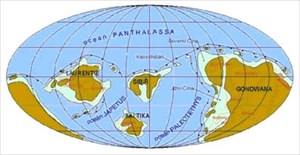
There was a shallow sea, in which they settled (on the bottom) of
bringing material from the mainland. Gradual deposition were formed
of rock layers, which can be seen on the exposed profile.
Among so called Letenský formatiion, which is a set of layers old
approximately 460 million years. For them is typical alternation of
sandstones, greywackes and siltstone.
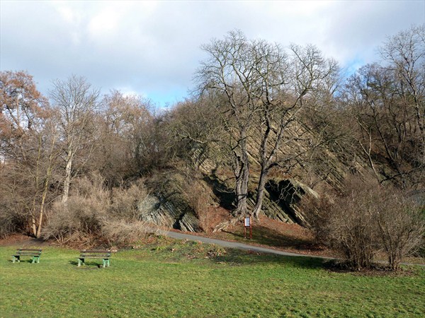
To reveal the profile is clearly visible as alternating layers of
coarse and fine grain, which is caused by changing the conditions
for their establishment. The shallow sea was turbulent and the
material, bringing by rivers, were sorted and transmitted by wave
action and marine currents. Thus, in periods of calm settled
finematerial, while at higher flow were formed coarse-grained
sediments .
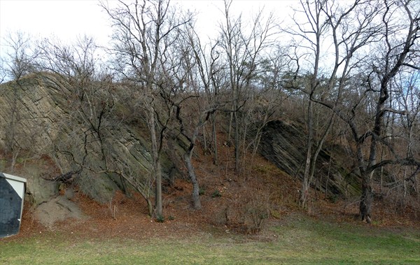
And why are layers sloping, when originally were deposited
horizontally on the seabed? This is due to conflict Gondwana with
other continents during the later Paleozoic. The collision of these
continents caused the Variscan orogeny (= Hercynian), in which the
rock pressure bended, highlighted or dropped. Therefore, we see
obliquely sloping.
Conditions for recognition of
the logo:
1) Send via e-mail address (GC-profile) to the following
questions:
• How long Ordovician lasted.
• Estimate the height of the exposed profile.
• Estimate the thickness of the thickest layer on the bottom
part of the profile behind the information board.
• How is called animal, that crawled along the surface of the
sea bottom and drilled corridors into the sediments (written on the
info-board).
• On which world site are layers sloped.
2) Optional task - attach the photograph of you (or your GPS) with
revealed profile - try it without a flood wall ;).
Do
not wait for the approval replay. You can send answers immediately,
and logging. If by chance something did not sit well, I'll
call.
[CZ]
Vítejte v
Libni
Odhalený skalní profil v Libni je tvoren morskými usazenými
horninami ordovického stárí. Ordovik je obdobím starších
prvohor (od 490 do 445 milionu let pred soucasností). V té dobe se
naše území nacházelo na severním okraji velkého kontinentu
nazývaného Gondwana, ležícího v mírném až chladném pásmu
jižní polokoule.
Bylo zde melké more, v nemž se na dne usazoval materiál
prinášený z pevniny. Postupným usazováním vznikaly vrstvy
hornin, které mužeme videt na odhaleném profilu. Patrí k tzv.
souvrství letenskému, což je soubor vrstev starý
približne 460 milionu let, pro než je typické strídání
pískovcu, drob a prachovcu.
Na odhaleném profilu je názorne videt, jak se strídají vrstvy
hrubozrnné a jemnozrnné, což je zpusobeno strídáním podmínek
pro jejich usazování. Melké more bylo neklidné a materiál,
prinášený rekami, byl prenášen a tríden cinností vln
a morských proudu. A tak se v obdobích klidu usazovaly jemné
materiály, zatímco pri vetším proudení vznikaly sedimenty
hrubozrnejší. A proc jsou vrstvy uklonené, když se
puvodne ukládaly vodorovne na morském dne? Je to zpusobeno dávným
stretem Gondwany s jinými kontinenty v prubehu pozdejších
prvohor. Kolize techto kontinentu vyvolala tzv. vrásnení variské
(=hercynské), pri nemž se horniny tlakem zprohýbaly, vyzdvihly
ci poklesly a proto je dnes vidíme šikmo uklonené.
Podmínky uznání
logu:
1) Pošlete via e-mail (GC-profil) na následující
otázky:
• Jak dlouho Ordovik trval.
• Odhadnete výšku odhaleného profilu.
• Odhadnete tlouštku nejtlustší vrstvy na spodní
cásti profilu hned za informacní tabulí.
• Jak se jmenuje živocich, který lezl po povrchu dna more
a vrtal do usazenin chodbicky (odpoved naleznete na
infotabuli).
• Na jakou svetovou stranu jsou vrstvy skloneny.
2) Nepovinný úkol: k logu priložte fotografii Vás (ci
Vaši GPSky) u odhaleného profilu – zkuste to bez
protipovodnové zdi ;).
Necekejte na schválení logu. Mužete poslat
odpovedi a hned logovat. Kdyby náhodou neco nesedelo, ozvu
se.
Additional Hints
(No hints available.)