|
Connection to the Earth Science Curriculum
Essential
Lessons:
Visitors
to Eagle Harbor Light Station will gain an understanding that the
rocks and other materials there serve as a record of the
region’s geologic history, including the role of the
mid-continental rift in the formation of the Lake Superior
Syncline.
Earth Science Literacy
Principles-
Big Idea
2: Earth is 4.6 billion years
old.
Big Idea
4: Earth is continuously
changing.
Common misconceptions
- Earth has
always been the way it is right now.
- All rocks
and planets were formed at the same time.
- All rocks
are more or less the same.
Michigan State Science Content Expectations
Addressed:
Third
Grade:
E.SE.E.2 Surface Changes- The surface of Earth changes. Some
changes are due to slow processes, such as erosion and
weathering; and some changes are due to rapid processes, such as
landslides, volcanic eruptions, and earthquakes.
E.SE.03.22 Identify and describe natural causes of change in the
Earth’s surface (erosion, glaciers, volcanoes, landslides,
and earthquakes).
Sixth Grade:
E.SE.M.4 Rock Formation- Rocks and rock formations bear evidence of
the minerals, materials, temperature/pressure conditions, and
forces that created them.
E
.SE.06.41 Compare and contrast the formation of rock types
(igneous, metamorphic, and sedimentary) and demonstrate the
similarities
E.SE.M.5 Plate Tectonics- The lithospheric plates of the Earth
constantly move, resulting in major geological events, such as
earthquakes, volcanic eruptions, and mountain building.
E.SE.06.51 Explain plate tectonic movement and how the lithospheric
plates move centimeters each year.
E.SE.06.52 Demonstrate how major geological events (earthquakes,
volcanic eruptions, mountain building) result from these plate
motions.
E.SE.06.53 Describe layers of the Earth as a lithosphere (crust and
upper
E.ST.M.4 Geologic Time- Earth processes seen today (erosion,
mountain building, and glacier movement) make possible the
measurement of geologic time through methods such as observing rock
sequences and using fossils to correlate the sequences at various
locations.
E
.ST.06.41 Explain how Earth processes (erosion, mountain building,
and glacier movement) are used for the measurement of geologic time
through observing rock layers.
E
.ST.06.42 Describe how fossils provide important evidence of how
life and environmental conditions have changed.
Vocabulary
Fresnel
lens- A large lens invented
by Augustin-Jean Fresnel which was crafted from smaller
lenses. It was lighter, thinner, and
flatter than conventional lenses and made lighthouses visible over
greater distances.
syncline-
a fold in
rocks, where younger rocks are found near the center
clinometer/
inclinometer – a tool
used to measure angles and slopes
compression–
when a
set of stresses or forces is directed at a rock mass
basalt–
a hard
black rock formed from slowly-cooled magma
basalticmagma
– molten
material from the upper mantle, which cools to form hard, black
volcanic rock
conglomerates–
sedimentary
rocks that are formed when larger, round fragments are cemented
together to form new rock
dip–
the
measure of the slope or tilt of rock layers
basalticflow
tops – the top
layers of lava flows, which are often porous and less
dense
floodbasalts
– basalts
formed in large eruptions when deep layers of lava spread over
great distances
Optional
Activity:
Visit the Lighthouse, Museums and Exhibits
The
lighthouse is open seven days a week in June, September and October
from noon to 5 pm, and in July and August from 10 am to 5 pm. There
is a $5.00 admission fee for adults.
Children are free. The admission covers
a hosted tour of the lighthouse, and entrance to the Keweenaw
Shipwreck Museum, the Commercial Fishing Museum, and an exhibit of
copper mining artifacts.
The
lighthouse and all of the buildings on site are maintained by the
Keweenaw County Historical Society, which gave their permission for
the creation of this EarthCache.
|
Eagle
HarborLake
Shore Traps
EarthCache
Perched
at the northern edge of the Keweenaw Peninsula, this red brick
lighthouse continues to guide ships safely across the harbor and
nearby waters of Lake Superior. The
rocky shore near the lighthouse provides visitors with an
opportunity to view Lake Shore Traps and the syncline formed by the
Mid-Continental rift found in Lake Superior’s
basin.
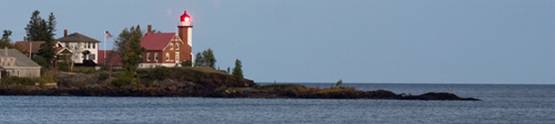
Figure 1: Eagle Harbor Lighthouse and
Lake Shore Traps.
Materials
Needed for your Visit
The
information provided, GPS, topographic map of the area, a compass,
a ruler, and a homemade clinometer (see
directions provided)
Directions:
- Check the
battery level in your GPS and make sure you know how to use it to
enter and label waypoints and navigate to a waypoint.
- Assemble
your clinometer.
- Navigate
to each of the stops.
- Read the
background material and answer the questions associated with each
stop.
Coordinates:
N 47°27.588’ W 88°09.614’
The
History of Eagle Harbor Light Station
The
lighthouse was built at Eagle Harbor to help mariners navigate the
treacherous waters of Lake Superior and to mark this rocky point
along the Keweenaw Peninsula. It was
first constructed in 1851 as a wooden structure with a Fresnel lens
lit by a sperm oil flame. When the
structure began to crumble under the harsh weather conditions along
the shore, the current lighthouse was constructed next to
it. The new lighthouse boasted a two
story keeper’s home and a 44-foot hexagonal light tower with
walls 18 inches thick. The Fresnel lens
was replaced by an aircraft-beacon-type lamp in 1962, and the
lighthouse was automated in 1980. It
remains operational today and is visible a full 29 miles from
shore. While the grounds and buildings
are maintained by the Keweenaw County Historical Society, the U.S.
Coast Guard is responsible for the routine maintenance of the light
itself (“Eagle Harbor Light Station”, 2011).
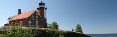
Figure 2: Eagle Harbor Lighthouse.
The
Formation of Lake Superior
Lake
Superior’s
history differs greatly from that of the other great
lakes. About 1.1 billion years ago, the
North American continent attempted to break apart along what became
known as the Mid-Continental Rift. This is one of the deepest rifts
in the world (Linder, 2006) and its curving path above
Michigan’s Upper Peninsula helped define the shape of Lake
Superior (Miller, n.d.).
|
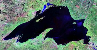
Figure 3: Lake Michigan. Satellite Image.
|
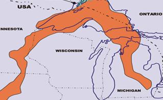
Figure 4: Mid-Continent Rift. The Rift
(in orange) extends from Detroit to the Midwest.
|
Continental
rifting has occurred repeatedly in the history of the
earth. It leads to the formation of
ocean basins and the fracturing of continents. In essence, the earth’s crust cracks and
begins to spread apart.
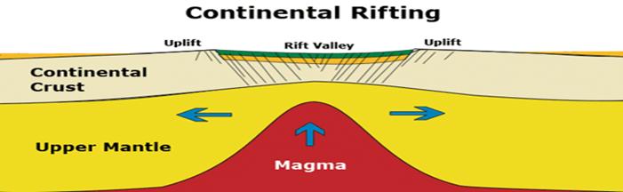
Figure 5: Continental Drifting.
Magma pushes up from the upper mantle as the two plates spread
apart.
A more recent example of
this can be seen in the active East African Rift zone, where the
African plate is breaking apart into two new tectonic plates, the
Nubian and Somalian plates.
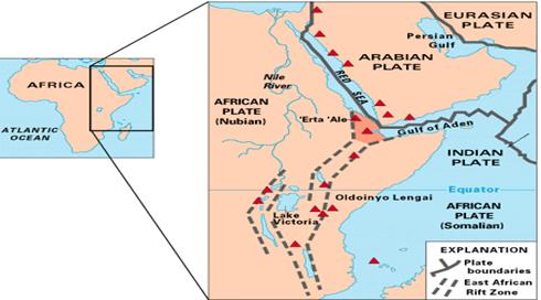
Figure 6: East African Rift. This rift
is a developing divergent plate boundary.
As
the crust spread apart in the Mid-Continental Rift, basaltic magma
rose to the surface and cooled. This
happened repeatedly as the rift expanded, erupting layer upon layer
of lava on the surface. In the time
between flows, sediments were deposited on top of these
layers. The rifting activity stopped
abruptly about 1 billion years ago. As
the dense layers of basalt cooled, they caused the rift valley to
sink (Miller, n.d.). Sediments
continued to fill this valley. Later,
compression (pressure coming from all sides) of this region caused
uplift, forcing the layers of basalt at the edges of the rift
upward until they were almost vertical in some places, forming what
is known as the Lake Superior Syncline.
The rocks on the shore of the Keweenaw Peninsula dip toward the
north, while the rocks on the southern edge of Isle Royale dip
southward, marking the edges of the syncline (Rose, n.d.). Examining the rocks in either location
allows visitors to glimpse some of the layers of the
syncline.
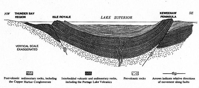
Figure 7: Midcontinent Rift System. Layers of
lava pooled on top of one another, causing the heavy center to
sink. Later, compression applied to the
region caused further uplift of the edges, forming what is known as
the Lake Superior Syncline.
Lake
ShoreTraps
As the
exposed layers of the Lake Superior Syncline have weathered over
time, they have created Lake Shore Traps in some areas. The word “trap” originated from a
Swedish term used to describe stacked lava flows that have
weathered to form a stair-step pattern (St. James,
2010). The traps visible along the
shoreline at Eagle Harbor were formed by the final lava flows of
the Mid-Continental Rift which occurred 1087 million years ago,
burying the conglomerate under 31 different flows with a maximum
thickness of 600 meters. The resulting layers of flood basalts and
conglomerates of the exposed Lake Superior Syncline have weathered
differentially to form this “stair-step”
pattern. Softer materials, usually the
basaltic flow tops have eroded away.
These become the bays in the harbor, while the more resistant rock
remains to become points or ridges (Rose, n.d). Some of these
ridges of resistant basalt are visible, but others create submerged
reefs in Eagle Harbor and along the shore of Lake Superior, which
make navigation in these waters extremely dangerous. The Lake Shore Traps seen along Eagle Harbor are
similar to the famous West Indian Deccan Traps.
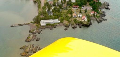
Figure 8: Eagle Harbor Light Station.
The lighthouse is seen here, along with the Lake Shore Traps that
shelter Eagle Harbor and are responsible for the jagged profile of
the coastline.
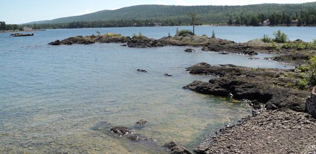
Figure 9: Lake Shore Traps. These
traps, remnants of the final lava flows that formed the Lake
Superior Syncline, jut out into Lake Superior making navigation in
these areas treacherous.
Tour of
Eagle Harbor Lake Shore Traps
Tour of
Eagle Harbor Light Station
Starting
Point: Lighthouse
Rd. off of
North St. Park in lot at N 47°27.588’ W
88°9.614’. Proceed
on foot to the Platform at Stop 1 while staying on established
trails.
Stop 1:
N47°27.599’ W88°9.602’ – overlooking
Northward Dipping Flood Basalts of the Lake Superior
Syncline
Several
layers of the flood basalts which comprise the Lake Superior
syncline are visible here. They
dip, or tilt, northward into the water due to the sinking of the
dense basalts into the rift zone in the basin of Lake Superior and
because of the compression applied to the syncline.
Logging
Q1: Gaze out into the lake a sketch your general location along the
Lake Superior Syncline. Which everyday
object(s) does the syncline resemble?
Look closely at the rock around you and describe it. What is its color and composition? Is it all basalt, or can you see other rock types
in the layers? Finally, use your
clinometer to measure the dip of these layers.
Stop 2:
N47°27.564’ W88°9.525 – Lake Shore Traps
Eagle
Harbor
is
sheltered by the trap lavas, which stretch out like long, thin
fingers into the water along the shore. The more resistant layers
of the basalt flows are all that remain. Softer materials have been worn away by waves and
glaciers over time, leaving the bays and pools between the ridges
or points of the traps.
Logging
Q2: Look at the traps along the shore.
Can you see any pattern or alignment among them? Describe the color and consistency of rock of
which they are comprised. Is it all the same? How do you think these geological features
impacted navigation in the waters in and around Eagle
Harbor? Why is the presence of a
lighthouse at this location of vital importance?
|
Making
and Using your own Clinometer
(Directions provided by Mark Klawiter)
A
clinometer (also known
as an inclinometer) is a tool used to measure the dip (tilt or
slope) of a geological feature. It’s easy and inexpensive to
make your own.
Materials
Needed:
a protractor with a hole in it, string, and a metal
nut
Directions:
Tie one end of the string through the hole in the protractor and
the other end to the nut.
Readingthe
clinometer:
Hold the clinometer upside down so that
the flat end is horizontal to the ground. This shows a slope of zero. Notice that the string hangs straight down,
measuring 90 degrees on the protractor.
When the slope is zero, your clinometer
will show a measurement of 90 degrees.
To find the dip of an outcrop, match the angle of the flat side of
the clinometer to the dip of the rock
you want to measure. The string will
hang straight down, pointing to the new measurement on the
protractor. To find the dip, subtract
90 from the new measurement.
Example:
If the clinometer string points to 135
degrees on the protractor, subtract 90 to find the true dip, or 45
degrees.
|
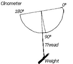
Figure 10: Clinometer Diagram. The
weight on the string causes it to hang straight down.
|
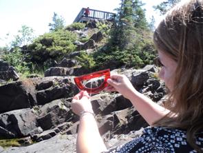
Figure 11: Reading
the Clinometer. Align the flat base of
the protractor with the rock layers you are measuring to find the
dip.
|
|
(This
EarthCache was created after visiting the Eagle Harbor on July 23,
2011.)
|
|
References
Clinometer
.
(2011).
Retrieved August 8, 2011, from Wikipedia
Website: http://en.wikipedia.org/wiki/Clinometer
Compression.
(2011). Retrieved August 8, 2011, from Wikipedia
Website: http://en.wikipedia.org/wiki/Compression_(geology)
Conglomerates,
(2011).
Retrieved August 8, 2011, from Wikipedia Website: http://en.wikipedia.org/wiki/Conglomerate_(geology)
East
African Rift. (2011).
Retrieved August 8, 2011, from Wikipedia Website:http://en.wikipedia.org/wiki/East_African_Rift
Fresnel
lens. (2011).
Retrieved August 8, 2011, from Wikipedia Website:
http://en.wikipedia.org/wiki/Fresnel_lens
Keweenaw
County
historical
Society.
(2011). Eagle Harbor Light Station [Brochure]. Eagle
harbor, MI: Kordes, M.
Lake Superior. (2011). Retrieved July 29, 2011, from Wikipedia Website:
http://en.wikipedia.org/wiki/Lake_Superior
Linder,
D.O., (2006). Simply superior: The world’s greatest lake.
Retrieved July 29, 2011, from:
http://law2.umkc.edu/faculty/projects/ftrials/superior/superior.html
Miller,
J. (n.d.). An
introduction to the geology of the north shore. Retrieved
July 29, 2011, from: http://www.lakesuperiorstreams.org/understanding/geology.html
Rose,
B. (n.d.). Eagle Harbor. Retrieved July 28, 2011, from: http://www.geo.mtu.edu/~raman/SilverI/MiTEP_ESI-1
Schaetzl,
R.J, Darden, J.T., & Brandt, D.S. (2009).
Michigan geography and geology. New York, NY: Pearson Custom
Publishing.
St.
James, J. (2010). Lake shore traps. Retrieved July 27, 2011 from:
http://www1.newark.ohiostate.edu/Professional/OSU/Faculty/jstjohn/UP%20Michigan%20geology/Lake%20of%20the%20Clouds.htm
Images
Aerial of
Eagle Harbor [Photograph].Retrieved
July 30, 2011, from:
http://www.geo.mtu.edu/~raman/SilverI/MiTEP_ESI-1/Eagle_Harbor.html
Clinometer
[Diagram].
Retrieved
July 30, 2011, from: http://www.glf.dfo-mpo.gc.ca/e0005794
Continental
Drifting [Diagram]. Retrieved
July 31, 2011, from: http://www.igorilla.org/assets/images/where/rifting.gif
Eagle
Harbor,
MI. [Photograph]. Retrieved July 30, 2011, from:
http://www.panoramio.com/photo/11492253?source=wapi&referrer=kh.google.com
Lake
Superior [Satellite
image]. Retrieved
July 30, 2011, from:http://en.wikipedia.org/wiki/Lake_Superior
Lake SuperiorSyncline [Diagram].
Retrieved
July 31, 2011, from: http://en.wikipedia.org/wiki/Midcontinent_Rift_System
Leonard,
K. (n.d.). Eagle HarborLighthouse [Photograph]. Retrieved July 30, 2011,
from: http://www.panoramio.com/photo/39496285
Mid-African Rift [Diagram].
Retrieved
August 8, 2011, from: http://en.wikipedia.org/wiki/East_African_Rift
Mid-Continent Rift [Diagram].
Retrieved
July 30, 2011, from: http://www.bitterrootresources.com/i/maps/Mid-Continent-Rift.gif |