Go To English Text
Kazalo
*
Uvod
*
Obmocje zgornjega Krasa
*
Geologija in nastanek jame
*
Opis jame
*
EarthCache
*
Viri
Skok na konec
teksta
Uvod
Divaška jama je nekoliko manj znana, a
zato nic manj impozantna podzemna kraška jama v bližini
Divace. Tudi njo je, podobno kot Škocjanske jame in še
nekaj drugih, ustvarila skozi milijone let reka Reka, ki pa zdaj
tece drugje in je zato Divaška jama suha jama.
Odkril jo je leta 1884 Gregor Žiberna,
imenovan Tentava. Za turisticni obisk so jo uredili že tri
leta za tem. Tentava se je pred tem prvi spustil v številne
jame, med njimi tudi v 180 m globoko vhodno brezno Kacne Jame, ki
leži nedalec stran od Divaške jame in vodi do podzemnega
toka Reke. S tem se je proslavil kot veliki raziskovalec
kraškega podzemlja ob koncu 19. stoletja.
Jama je eden najstarejših ohranjenih
rovov reke Reke, ki danes nedalec stran ponika v znamenite
Škocjanske jame. Ogled je zanimiv, saj je jama z množico
udornih dolin in brezen v okolici Divace del nekdaj aktivnega
jamskega sistema, ki ga je na tem obmocju oblikovala Reka. Je
izvrstna priložnost za spoznavanje in razumevanje razvoja
kraških pojavov na Divaškem Krasu. Skozi dolgo
geološko zgodovino se je skoraj v celotnem rovu odložilo
veliko sige, ki z zanimivimi tvorbami krasi njeno notranjost.
Že v preteklosti so jamo obiskovale znane osebnosti. Med njimi
velja izpostaviti prestolonaslednika princa Rudolfa, po katerem se
je nekaj casa tudi imenovala Rudolfova jama (Rudolfsgrotte), in
slovitega psihoanalitika Sigmunda Freuda.
Obmocje zgornjega Krasa
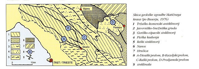
Geološka zgradba Maticnega krasa
Generalizirana geološka karta Krasa (Cerkvenik, 2005)
Celotni Maticni Kras, apnencasto podolje med
Tržaškim zalivom in Vipavsko dolino, je razgibana enota.
Eocenski fliš, morski sediment, ki je na debelo prekrival to
podrocje, se je dvignil nad morsko gladino in nato vzdrževal
površinsko recno mrežo. Ob dvigovanju, gubanju in nato
prelamljanju plasti je bila antiklinalna guba Krasa razgaljena in
erodirana do starejših apnencev, vecinoma kredne starosti,
kjer so se zaceli kraški procesi. Za Zgornji Kras je znacilno
stikanje med apnenci in fliši, tako da so apnenci spodaj,
fliš pa je naložen na njih. Vzhodno od Zgornjega Krasa so
flišni Brkini, kjer je recna mreža površinska,
celotna recna mreža pa se steka vecinoma na zahod, kjer se
ponori Reke koncajo v Škocjanskem jamskem spletu, in na jug z
mnogimi krajšimi vodotoki, ki se koncajo v ponorih v tako
imenovanih slepih dolinah Matarskega podolja.
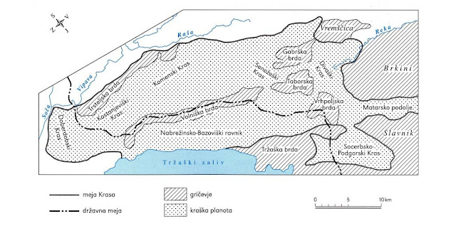
Morfološke enote Krasa in okolice (Gams, 2003)
Ponori primorske Reke so v geološki
zgodovini ustvarili velikanski sistem podzemeljskih rovov in
dvoran, v razlicnih višinah in v razlicnih smereh proti
zahodu, severozahodu in jugozahodu. Erozijsko širjenje in
poglabljanje ter znižanje korozijskega površja je
ustvarjalo notranje podore, ožine in udorne vrtace s
površja, zato je Reka stalno spreminjala svoj tok v globini,
ceprav je vsaj v prvih desetih kilometrih sklenjen. Ob poplavah
voda Reke zapolni višje rove. Škocjanske jame in Kacna
jama sta del tega sistema, del starega višjega in zdaj mrtvega
sistema pa je tudi Divaška jama.
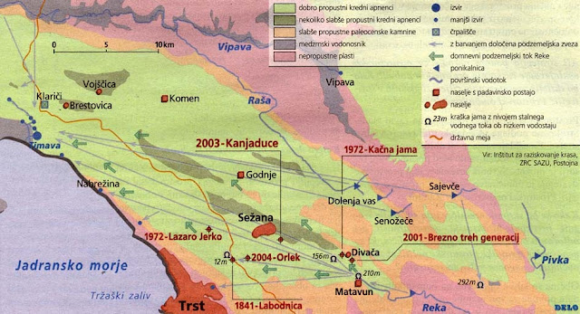
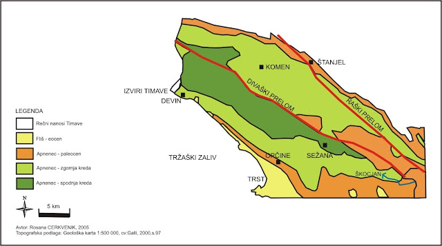
Hidrogeološka karta Krasa (Mihevc, 2004)
Geologija in nastanek jame
Širše obmocje Divaške jame
tvorijo mikritni in sparitni kredni apnenci turonijske starosti,
ki sestavljajo veliko geološko gubo tako imenovanega
tržaško-komenskega antiklinorija. Skladi upadajo za 20
stopinj proti jugu in jugozahodu. Skladi so
prelomljeni, vendar le malo zdrobljeni.
Podzemlje Divaške jame je v skladovitih
apnencih, ki so v prvi polovici jame nagnjeni za 15-20 stopinj
proti jugozahodu, v drugi polovici pa za prav toliko proti jugu.
Ker skalni profili jame niso nikjer v celoti razgaljeni, je
težavno spoznati tudi razsežnosti in oblike skalne
izvotlitve. Gre za enotni rov, ceprav skorajda popolnoma
preoblikovan. Zelo verjetno je sedanji rov le vrh velikega
podzemeljskega kanjona. Lepo so razvidne velike zapolnitve
prostorov z ilovico, podori in sigami skorajda do vrha, nato pa je
z mocnim izpiranjem z meteorskimi vodami prišlo do ponovne
izvotljenosti podzemeljskega rova med vhodom 426 m do 350 m
nadmorske višine z dolžino kakšnih 700 m. V zadnji
fazi se je jama ponovno mocno zasigala z mnogimi sigastimi oblikami
(stalagmiti, stalaktiti, stebri, zavese, baldahini itd.), tako da
težko najdemo živo skalo.
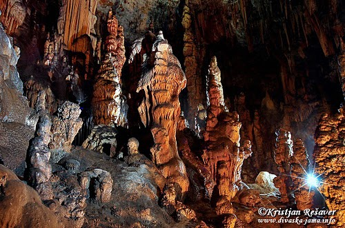
Opis jame
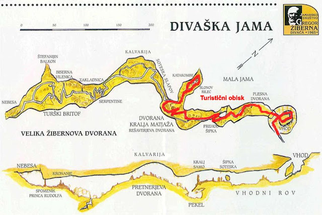
Nacrt jame
Divaška jama ima dva vzporedna navpicna
vhoda na nadmorski višini 427 m. Zdajšnji glavni je vhod
skozi udorno vrtaco, kjer je speljana pot, ter se na dnu zoži
(tu je bil skopan umetni prehod že leta 1886) in pride po
podornem nasipu v Vhodno dvorano. Ob robu podorne vrtace pa se v
Vhodno dvorano navpicno spusti v 25 m globoko brezno, prva leta
edini prehod v jamo, ki so ga premošcali z vrvnimi in nato z
lesenimi lestvami.
V vhodnem prostoru, imenovanem Plesna
dvorana (Vhodna dvorana), kamor še sega dnevna
svetloba, so tla umetno poravnana. Od tu vodi
17 m širok in 15 m visok podzemeljski rov in jamska pot
pod podrtim stalagmitom. Na JZ skalni steni se vzpenjajo kope sige
in debeli stalagmiti, od katerih sta dva v podnožju
prelomljena in nagnjena. Dno vhodnega rova se spušca do
najnižjega dela prostora, kjer se pozimi zadržuje hladen
zrak, poleti pa se zrak dnevno ohlaja zaradi nocnih temperatur.
Zaradi tega je siga v rovu posebne sive barve in oblike. Po
80 m se vhodni rov konca, dvigne in zoži do stranske
niše, imenovane Samotarjeva molilnica.
Jamska pot pelje cez Prehod Šipka
(Obhod) v Šipka sotesko, 20 m dolg odsek jame,
posut z množico velikih stalagmitov, kjer se mešata
vhodni in jamski zrak. Šipka (robidovje) je staro ime za ta
del jame zaradi koralastih izrastkov po stenah in kapnikih.
Rov se rahlo spusti in tu ni vec vplivov
z vhoda in pozimi nas objame toplejši in vedno vlažen
zrak. Tla rova, polnega kop, sigovih cipres in svec, se
znižajo, rov pa se poveca in razširi v 40 m dolgo
Dvorano kralja Matjaža (Rešaverjevo dvorano),
z markantnimi kapniškimi oblikami in podrtim mogocnim
stalagmitom Kralj Matjaž, po Gospodaricu imenovanem
Harambaša, nad njim pa stoji stalagmit Kralj
Samo (nekaj casa znan tudi kot Tegethoffov spomenik). Na
steni je lep bel sigast Slap Savice. Na dnu dvorane je udor
Pekel, po Gospodaricu Hram; od tu vodi odcep v
stranski rov v Malo jamo, po Žiberni imenovan Muzej
umetnosti.
Glavni rov se nato zožuje cez Sotesko
slapov (Hodnik), dolžine 30 m, kjer se zoži na
5m širine, z znacilnimi slapovi sige na stranskih stenah. Rov
se kmalu razširi in dvigne v 70 m dolgo Kalvarijo
( po Gospodaricu Pretnerjevo dvorano), kjer je znacilno
kapniško pobocje z gozdom stalagmitov in stebrov. Tu se jamska
pot razcepi - na levi strani Kalvarije poteka glavna pot ob
vznožju pobocja, na desni strani pa se dvigne in spusti ter se
spet združi z glavno levo potjo.
Turisticna jamska pot se nadaljuje
na razgledni rob Belvedere, kjer se odpre pogled na
Veliko dvorano, kot so jo imenovali Tentava in
tovariši. Rov je 100m dolg, do 40 m širok in do 20m
visok. Zdaj ga imenujemo Žibernova dvorana. Jamska pot
se strmo serpentinasto spusti na dno dvorane, ki je tudi
najnižja tocka jame, 72 m nižje in 500 m dalec od vhoda.
Tu je prehod v 20 m globoko ožje brezno. Ob poti je zanimiv
stalagmit Atilova pipa, kot ga je poimenoval Tentava. Jamska
turisticna pot se spet dvigne na Turški britof,
kjer se na desno odcepi stranska pot v Biserno
Vilenico in Zakladnico z mnogimi belo-rdecimi
zavesami, helektitnimi izrastki in velikimi kristali. Glavna pot se
v zgornjem delu dvorane spet razcepi. Na desni strani je stranski
strmi kapniški rov, nekoc imenovan Štefanijin
balkon, na levi strani pa lepo zasigan podor s kapniškimi
skupinami Kronski gric in Spomenik princa Rudolfa.
Jama se konca z dvignjenim kapniškim rovom,
imenovanim Nebesa ali Paradižem in
Nebeškimi orglami.
V dvorani kralja Matjaža, kjer je severni
odcep v Malo jamo, ki jo je Tentava imenoval Muzej
umetnosti, je jamska pot prehodna samo z mostom cez
prepad Pekel (po Gospodaricu Hram), ki je do 10
m globok s 30 m dolgim rovom na dnu. Mala jama je dolga do 60 m,
posejana z mnogimi lepimi kapniškimi oblikami:
stalagmiti Mumije, Cipresa in Kitajska vaza, s
strani pa visi velik baldahin, s katerega raste
stalaktit Slonov rilec. Kapniški rov se
konca z udorom v sigini plošci, poimenovan
Katakombe.
Celotna dolžina Divaške jame je 700
m, globina pa 95 m. V njej je speljanih 1500 m poti, za
turisticne oglede pa je le poredko odprta. Za vec informacij o
ogledu se velja obrniti na skrbnika, Jamarsko društvo Gregor
Žiberna iz Divace.
EarthCache
Vhod v Divaško jamo je enostavno dostopen
s ceste Divaca – Lokev na Krasu - Lipica, kjer nas po
kilometru ali dveh izven Divace obcestna tabla usmeri desno. Nekaj
deset metrov naprej je parkirišce (tocka PARK), do vhoda pa je
še nekaj metrov hoje, ki nas spusti v kraško vrtaco, na
dnu katere je vhod v jamo (tocka CAVE).
Za registracijo te
EarthCache tocke morate odgovoriti na naslednja vprašanja:
1.
Ocenite dimenzije (globina in premer) vrtace, v kateri je vhod v
jamo.
2.
Konec Divaške jame (Nebesa) sega skoraj do še ene
kraške jame v bližini, le da je približno 50 m pod
njo. Za katero jamo gre?
3.
Koliko stopnic je do železnih vrat, ki zapirajo vhod v
jamo?
4.
Kot neobvezno nalogo pa naredite fotografijo vas ali vašega
GPSja pri jami in jo pripnite vašemu vpisu.
Odgovore mi
pošljite skozi GC profil. Potem lahko zabeležite vaš
obisk, ne da bi cakali na posebno dovoljenje. Ce ste fotografirali,
priložite zanimive fotografije.
Table of
Contents
*
Introduction
*
Upper Karst
area
*
Geology and formation of the
Cave
*
Description of the
Cave
*
EarthCache
*
Sources
Go To Bottom
Introduction
Divaca cave is somewhat less known, but no less impressive
underground Karst cave near Divaca. It was, like Škocjan caves
and a few others, created over millions of years by the river Reka,
which now runs elsewhere, making Divaca cave a dry cave.
Cave was discovered in 1884 by Gregor Žiberna, called
Tentava. It was arranged for tourist visits three years after that.
Tentava was the first to go into a number of caves before that,
including the 180-meter deep entrance shaft of Kacna cave, which
lies not far from Divaca cave, leading to an underground river
Reka. These successes made him one of the greatest explorers
of karst underground in the late 19 century.
The cave is one of the oldest surviving passages of the
river Reka, which currently terminates near the famous Škocjan
caves. Visiting Divaca cave makes an interesting tour, since
together with numerous collapse valleys and shafts in the vicinity
of Divaca it is a part of once active cave system, which was formed
by river Reka. It is an excellent opportunity to learn and
understand the development of karst phenomena in Divaca Karst.
Through a long geological history, almost the entire tunnel became
richly decorated with interesting calcite formations. Historically,
many celebrities have visited this cave. Among them, we should
mention Crown Prince Rudolf, after whom the cave was one time
called Rudolph Cave (Rudolfsgrotte), and the famous psychoanalyst
Sigmund Freud.
Upper Karst
area
Karst geological structure
Generalized Geological Map of Karst (Cerkvenik, 2005)
Whole central Karst, limestone valley between the Gulf of
Trieste and Vipava Valley, is a very diverse area. Eocene flysch,
marine sediment, which was thickly covering this area, rose above
the sea level and then maintain the surface river network. When
lifting, corrugation, and then breaking of layers, Karst anticlinal
fold was exposed and then eroded to the older limestone, mostly of
Cretaceous age, where karst processes began. Characteristic for the
upper Karst is juncture between the limestone and flysch, so that
the limestone is on the bottom while flysch is loaded on it. East
of the Upper Karst lay flysch Brkini, where the water network runs
on the surface. Entire water network is channeled mainly to the
west, where the river Reka sinks in Škocjan Caves, and to the
south with many short streams that end up in the sinks of Matarska
valley.
Morphological units of Karst and surroundings (Gams, 2003)
River Reka created in the geological history a huge
underground system of tunnels and chambers in various heights and
in different directions: towards the west, northwest and southwest.
Erosion and reduction of surface materials caused surface cavings
and sinkholes which have been constantly changing flow of the
river, although at least the first ten kilometers are
uninterrupted. During floods river Reka still fills some of the
higher galleries. Kacna Cave and Škocjan caves are part of
this system, whereas the Divaca cave is higher and part of the old
and now dead cave system.
Karst Hydrogeological map (Mihevc, 2004)
Geology and
formation of the Cave
The wider area of Divaca cave consists of cretaceous
limestone, which forms a geological fold. These limestone
stratification decreases by 20 degrees to the south and southwest.
They are broken, but only a little crushed.
Divaca cave underground lies in stratified limestone which
in the first half is inclined 15-20 degrees to the southwest, in
the second half by as much towards the south. Since the rock
profiles are nowhere in the cave completely stripped down, it is
difficult to know the dimensions and shape of rock hollowing. The
cave is a single tunnel, although almost completely reshaped. It is
likely just the tip of the large underground canyon. In the final
stage the cave again became filled with many forms of calcite
(stalagmites, stalactites, columns, curtains, canopies, etc.),
which makes finding bedrock very difficult.
Description
of the Cave
Cave plan
Divaca cave has two parallel vertical inputs at an altitude
of 427 m. The current main entrance is through a karst sinkhole,
where the path leads and narrows at the bottom (there was an
artificial passage dug already in 1886) to eventually enter the Entrance Hall. By the edge of the
sinkhole there’s a vertical 25 m deep shaft that leads
directly to the Entrance Hall. In the first few years this was the
only way to enter the cave, with ropes or wooden
ladders.
In the entrance room,
called the Dance Hall (Entrance Hall), where there’s
still daylight, floor was artificially leveled. From here the
path leads through 17 m wide and 15 m high underground tunnel,
under a fallen stalagmite. On the SW rock wall there are piles of
calcite and thick stalagmites, two of which are at the foot broken
and skewed. The bottom of the input shaft descends to the lowest
part of the area where in the winter cold air is trapped and in the
summer air is cooled by the night temperatures. Because of this
calcite formations have special gray color and shape. After 80 m,
the input shaft ends, ascents and tightens into a side niche,
called Samotarjeva Molilnica (Loner’s
Oratory).
Cave path then leads through the Šipka Pass
(Bypass) into the Šipka gorge, 20 m long section of the cave,
strewn with a multitude of large stalagmites, where the cave and
outside air are mixing. Šipka (bramble) is an old name for
this part of the cave because of coral-like growths on the walls
and dripstones.
Passage then drops slightly and outside air can no longer
be felt but instead there’s warmer and always moist cave air.
Soon passage widens to 40 m long Hall of King
Matjaž (a.k.a. Rešaver Hall), with impressive
dripstones and mighty fallen stalagmite named King
Matjaž (Gospodaric called it Harambaša) and above it
there’s stalagmite King Samo (also known for some time
as a monument of Tegethoff). On the wall is a beautiful white
Savica Waterfall. At the bottom of the hall there’s
landslip Pekel (Hell) and from there tunnel branches to
Little cave, which Žiberna called Art
Museum.
The main tunnel then narrows into the 30 m long Gorge of
Waterfalls (Hallway), where it narrows to a width of 5m, with
typical calcite waterfalls on the side walls. The tunnel will soon
expand and rise into the 70 m long Calvary (Gospodaric
called it Pretner Hall), which is characterized by slope with a
forest of stalagmites and columns. Here are the cave path splits -
on the left side of Calvary the principal route runs at the foot of
the slope while on the right hand side it raises and drops again to
join the main left path.
Tourist cave path continues to the edge of the
Belvedere lookout, where the view opens to the Great
Hall, as was dubbed by Tentava and comrades. The tunnel is 100m
long, up to 40 m wide and up to 20m high. Nowadays it is called
Žiberna Hall. Path then descends sharply to the bottom
of the hall, which is also the lowest point of the cave, 72 m lower
and 500 m far from the entrance. Here is a passage to the 20 m deep
narrow pit. On the way there’s an interesting stalagmite that
Tentava named Attila's pipe. Tourist trail rises again to
the Turkish graveyard where on the right side road branches
off to Pearl Vilenica and Treasury with many
white-red curtains and large crystals. The main trail splits again
in the upper part of the hall. On the right hand side there’s
steep tunnel, once called Štefanija balcony, and on the
left side a beautiful rockfall with stalactite groups, Crown
Hill, and Crown Prince Rudolf Monument. The cave ends
with a raised tunnel called Heaven or Paradise and
with Heaven organ.
In the hall of King Matjaž with the branch to the
Little cave, which was called by Tentava the Art
Museum, the cave trail is only transitive over a bridge across
the abyss of Hell which is up to 10 m deep with a 30 m long
tunnel at the bottom. Little cave is 60 m long, planted with many
beautiful calcite forms: Mummies stalagmites, Cypress
and China vase, while on the side hangs a large canopy, from
which the stalactite Elephant Trunk grows. Passage ends with
a landslip, called the Catacombs.
The entire length of the Divaca cave is 700 m and it is 95
m deep. There are 1500 m of visitor’s route, but it is seldom
open for visitors. For more information about visiting contact the
administrator, the Speleological Society Gregor Žiberna in
Divaca.
EarthCache
The entrance to the
Divaca Cave
is easily
accessible from the road
Divaca -
Lokev na Krasu
- Lipica,
where after a kilometer or two outside Divaca a roadside
sign will direct you to
the right. Very soon you’ll arrive to the parking space (waypoint
PARK). From there one has to walk for a
few meters into
the karst sinkhole at the bottom of which
the entrance to the cave
is (waypoint CAVE).
To register this EarthCache you must answer
the following questions:
1.
Assess the
dimensions (depth and diameter) of the
sinkhole in which
the entrance to
the cave is.
2.
End of the Divaca Cave (Heaven = Nebesa)
extends almost to
another cave
nearby, but is approximately
50 m below it. Which cave is this?
3.
How many
steps are there on the
staircase to the iron
gate that closes the entrance to the
cave? Count all steps not just the metal
ones.
4.
Optionally, take a photo of yourself or your GPS
and attach it to your log.
Send your answers through my GC profile. After that you can
log your visit, don't wait for permission from me. If you took
photos, attach them to your log.
Logs without the answers sent to me or logs containing the
answers will be deleted!
Skok na zacetek teksta / Go To
Top
Viri / Sources:
*
Wikipedia
*
Jamarsko društvo Gregor Žiberna, Divaca
*
Rosana Cerkvenik, 2006. Speleološke znacilnosti krasa,
Diplomsko delo
*
Gams, I., 2003. Kras v Sloveniji v prostoru in casu, Ljubljana,
Založba ZRC, ZRC SAZU
*
Mihevc, A., 2004. Iskanje podzemnega toka reke Reke. Delo. Znanost,
(26.4.2004)