Deutsch:
Die Entstehung Andalusiens
Wie ein Gebirge aus dem Meer stieg
Die nördliche Grenze Andalusiens bildet ein 400 Kilometer langes und etwa 900 Meter hohes Mittelgebirge, die Sierra Morena. Erdgeschichtlich ist sie das älteste Gebiet Andalusiens. Im Erdaltertum (Paläozoikum) vor rund 420 Millionen Jahren war dort noch ein Meer. Die Erdkruste war in Bewegung, sie hob und senkte sich. Die Ablagerungen am Grund des Meeres bildeten gewaltige Sedimentschichten. Durch Bewegung und Druck der Erdkruste entstand aus diesen Schichten Schiefer, Gneis und Quarzit.
Flüssige Gesteinsschmelze (Magma) drang aus dem Erdinneren nach oben und erstarrte zu Granit. Ein Gebirge bildete sich und erhob sich vor rund 300 Millionen Jahren aus dem Meer. In Gesteinsgängen sonderten sich dabei Erze ab: Eisen, Blei, Gold und Silber. Schon in der Antike wusste man, dass dieSierra Morena reich an Bodenschätzen ist.
Die Falten der Sierra Nevada
Zu Beginn des Erdmittelalters (Mesozoikum), vor rund 200 Millionen Jahren, trennte sich, was zuvor vereint war: Europa und Afrika drifteten auseinander. Das Tethys-Meer entstand, ein Vorläufer des Mittelmeers, das aber fünf Mal so groß war wie das heutige Mittelmeer. Dort lagerten sich im gesamten Erdmittelalter riesige Sedimentschichten ab, bis es in der Erdneuzeit (Känozoikum), 150 Millionen Jahre später, wieder zu Umbrüchen kam. Die Kontinentalplatten Europas und Afrikas kamen jetzt aufeinander zu und das Tethys-Meer wurde immer schmaler.
Dadurch schoben sich die inzwischen 2000 Meter dicken Sedimentschichten zu einem Faltengebirge zusammen. Auf diese Weise entstand in Andalusien ein 600 Kilometer langer Gebirgszug, die BetischeKordillere mit der Sierra Nevada. Durch die gewaltige Bewegung erhoben sich in Europa und Asien weitere Faltengebirge wie der Himalaja, der Kaukasus, der Apennin, die Alpen und die Karpaten.
Ursprünglich war die Betische Kordillere mit dem marokkanischen Rif-Gebirge verbunden, da es die Straße von Gibraltar, die Meerenge zwischen Mittelmeer und Atlantik, noch nicht gab. 20 Millionen Jahre lang hob und faltete sich das Gebiet in Andalusien, bis sich vor fünf Millionen Jahren ein Teil wieder senkte. Da erst entstand im Süden Andalusiens die Straße von Gibraltar.
Um diesen Cache zu loggen, mailt mir die Antworten auf diese Fragen:
1) Erstelle eine Zeichnung mit der Darstellung des Tethysmeer mit Europa und Afrika im Vergleich zum heutigen Mittelmeer mit Europa und Afrika.
Diese bitte mit dem Log uploaden.
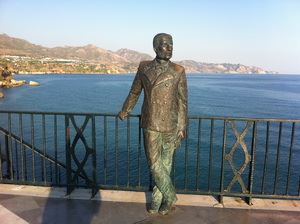
2) Welcher Name steht als letztes auf dem Schild von "El Rey Alfonso XII"?
Über ein Bild von Euch neben "El Rey Alfonso XII" würde ich mich freuen.
Danach könnt Ihr loggen, wenn etwas nicht stimmen sollte, melde ich mich.
English:
The origin of Andalusia
How mountains from the sea rose
The northern border of Andalusia forms a 400-kilometre-long and about 900 metre high low mountain range, the Sierra Morena. She is geological the oldest area of Andalusia. In the earth antiquity (Paläozoikum) before about 420 million years was there one more sea. The earth's crust was in movement, she lifted and fell. The depositions in the reason of the sea formed immense sediment layers. From movement and pressure of the earth's crust originated from these layers of slates, gneiss and quartzite.
Liquid rock glazes (magma) penetrated from the interior of the earth upwards and solidified to granite. Mountains formed and rose before about 300 million years from the sea. Besides, in rock ways ores secluded themselves: Iron, lead, gold and silver. Already in the antiquity one knew that dieSierra Morena is richly in mineral resources.
The folds of the Sierra Nevada
At the beginning of the earth Middle Ages (Mesozoikum), before about 200 million years, separated what was united before: Europe and Africa drifted apart. The Tethys sea originated, a precursor of the Mediterranean Sea which was so big, however, five spots as the today's Mediterranean Sea. There gigantic sediment layers deposited in the whole earth Middle Ages, until it came in the earth modern times (Känozoikum), 150 million years later, again to layouts. Now the continental records of Europe and Africa came up on each other and the Tethys sea became always narrow.
The sediment layers 2000-metre-thick in the meantime thereby telescoped to a Faltengebirge. In this manner a 600-kilometre-long mountain range, the BetischeKordillere with the Sierra Nevada originated in Andalusia. By the immense movement other Faltengebirge rose in Europe and Asia like the Himalayas, the Caucasus, the Apennines, the Alps and the Carpathian Mts.
Originally was connected the Betische Kordillere with the Moroccan Rif mountains, because there was not the street of Gibraltar, the strait between the Mediterranean Sea and the Atlantic, yet. The area lifted and folded 20 million years in Andalusia, until before five million years a part fell again. There only originated in the south of Andalusia the street of Gibraltar.
To log these Cache, mails me the answers to these questions:
1) Provide a drawing with the representation of the Tethysmeer with Europe and Africa in comparison to the today's Mediterranean Sea with Europe and Africa.
These please with the log uploaden.
2) Which name stands as last on the sign of "El Rey of Alfonso XII"?
I would be glad about a picture of You beside "El Rey of Alfonso XII".
Then you can log if a little bit should not be right, I contact.
español
El origen de la Andalucía
Cómo montañas del mar subían
La frontera del Norte de la Andalucía forma una montaña de media altura de 400 kilómetros de largo y de aproximadamente 900 metros de alto, Sierra Morena. Ella es geológica la región más vieja de Andalucía. En Erdaltertum (Paläozoikum) antes de aproximadamente 420 millones de años era allá todavía un mar. Erdkruste era en el movimiento, ella levantaba y se bajaba. Los sedimentos en la causa del mar formaban capas de sedimento tremendas. Del movimiento y presión de Erdkruste se producía de estas capas al esquisto, gneis y cuarcita.
Esmaltes de roca (magma) líquidos insistía de Erdinneren arriba y se solidificaba al granito. Montañas se formaban y se levantaban antes de aproximadamente 300 millones de años del mar. Con esto en marchas de roca minerales se aislaban: Hierros, plomo, oro y plata. Ya en la Antigüedad se sabía que dieSierra Morena es muy en riquezas del subsuelo.
Los pliegues de Sierra la Nevada
A principios de Erdmittelalters (Mesozoikum), antes de aproximadamente 200 millones de años, se separaba que estaba unido antes: Europa y África derivaban por separado. El Tethys mar se producía, un precursor del Mar Mediterráneo que era tan grande sin embargo cinco veces como el Mar Mediterráneo de hoy. Allá capas de sedimento gigantescas se posaban en Erdmittelalter todo, hasta que se produjeran en Erdneuzeit (Känozoikum), 150 millones de años más tarde, de nuevo revoluciones. Ahora las placas continentales de Europa y África se dirigían uno sobre el otro y el Tethys mar se hacía siempre más estrecho.
Por ahí las capas de sedimento de 2000 metros de espesor entretanto se aproximaban a montañas de pliegues. De este modo un tren de montañas de 600 kilómetros de largo, BetischeKordillere con Sierra la Nevada se producía en la Andalucía. Por el movimiento tremendo otras montañas de pliegues se levantaban en Europa y Asia como la Himalaya, el Cáucaso, los Apeninos, los Alpes y los Cárpatos.
Originalmente estaba ligado Betische Kordillere con las Rif montañas marroquíes, dado que aún no había la calle de Gibraltar, el estrecho entre el Mar Mediterráneo y Atlántico. La región se levantaba y plegaba 20 millones de años en la Andalucía, hasta que antes de cinco millones de años una parte se bajara de nuevo. Allí sólo la calle de Gibraltar se producía en el sur de la Andalucía.
Para medir con corredera estos Cache, me manda por correo electrónico las respuestas a estas preguntas:
1) Haz un dibujo con la representación de Tethysmeer con Europa y África en comparación con el Mar Mediterráneo de hoy con Europa y África.
Estos por favor con la borda.
2) ¿Qué nombre está como último en el letrero de "El Rey de Alfonso XII"?
Me alegraría por una imagen Vo junto a "El Rey de Alfonso XII".
Después podéis medir con corredera si un poco no debía ser cierto, me presento.