Belvédère de Navoirat Traditional Geocache
-
Difficulty:
-

-
Terrain:
-

Size:  (regular)
Please note Use of geocaching.com services is subject to the terms and conditions
in our disclaimer.
FRANCAIS
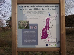
Le site domine par un point de vue remarquable le bourg de Menat,
offre une vue exceptionnelle sur Château-Rocher et surplombe le
méandre de Rochocol sur la Sioule. II est situé sur Ie territoire
des sites Natura 2000 des Gorges de la Sioule. * N° FR 830 1034 de
la Directive Habitats, * N° FR 831 2003 de la Directive Oiseaux. Ce
point de vue est fréquenté régulièrement par un large public. Les
équipements qui y sont proposés méritent d’être remis à jour.
Pour arriver au point de vue, les visiteurs utilisent une piste en
terrain naturel aménagée par quelques marches visant à en faciliter
I’accès et en limiter I’érosion. Cette voie traverse
une ”lande sèche à callune”, habitat protégé identifié
dans Ie cadre de la gestion des sites Natura 2000 des ”Gorges
de la Sioule”. Cet habitat subit actuellement diverses
perturbations : > il est possible d’y constater une
présence de plus en plus importante de bouleaux, de genêts et de
ronces qui colonisent Ie site au détriment de la callune, > de
plus, la fréquentation des lieux entraîne un piétinement diffus des
zones à callune par un public parfois ignorant de la nécessité de
protéger un tel milieu. Afin de réhabiliter ce point de vue
remarquable constituant un complément à I’offre touristique
locale, la commune de Menat souhaite revoir I’aménagement des
lieux tout en informant et sensibilisant Ie public et les acteurs
locaux sur la nécessité de protéger les habitats et espèces
remarquables pouvant s’y rencontrer. Le projet est une
reprise d’un aménagement existant et dégradé qui consiste en
un belvédère situé à I’aplomb d’un méandre de la Sioule
et à proximité de falaises riches en avifaune. Le cheminement pour
accéder au belvédère est également tracé et chemine dans la lande
sèche. Les travaux prévoient : > l’organisation de la mise
en défens de la zone. > la restauration de cette lande en 2010
en limitant la végétation envahissante, suivie d’opérations
d’entretien annuelles pendant quatre ans. Organisation de la
mise en défens de la zone L’intervention consistera à agir
sur le mode de fréquentation du site par le public : - Des
barrières alternées avec des blocs de pierres protègeront
l’entrée et le début de la lande, - Le stationnement des
véhicules motorisés sera transféré plus haut sur un espace parking
indiqué par deux panneaux, - En bordure de la route goudronnée, une
clô-ture deux fils sera installée sur une longueur d’environ
50 m pour éviter toute pénétration. L’accès piétonnier au
belvédère sera canalisé. Pour améliorer le cheminement, 18 marches
constituées de rondins de 2 mètres y seront implantées. Une lisse
sera posée sur 60 mètres de manière à éviter la divagation sur la
lande. Aménagements visant à informer les usagers pour limiter leur
impact L’information sera dispensée à deux niveaux : - sur le
panneau d’accueil du site avec une portée locale Iiée à la
lande à callune, sur le visuel du belvédère avec une portée plus
générale liée au point de vue et aux sites Natura 2000. Accueil des
visiteurs : En complément de l’information, deux tablesbancs
seront installées à l’entrée ainsi que deux dispositifs
”assis-debout” au niveau du belvédère. Une barrière de
protection limitera l’accès aux pentes abruptes.
L’étude et les travaux sont conduits par l’Office
National des Forêts Auvergne-Limousin. Le financement du projet est
assuré par un contrat ”Natura 2000” intégrant des
subventions de l’État et du Fond Européen à hauteur de 71,5 %
et une participation communale de 28,5 %.Ainsi, cet aménagement
pourra contribuer à mieux faire connaître le patrimoine de la
vallée de la Sioule. II servira aussi de base démonstrative à la
sensibilisation des populations locales et de leurs représentants
que sont les élus locaux. II constitue un véritable outil de
développement durable qui doit permettre de combiner protection du
milieu et développement local.
ENGLISH
The site overlooks an outstanding view of the town Menat offers an
exceptional view of Castle Rock-and overlooks the meander on
Rochocol Sioule. It is located on Ie territory Natura 2000 sites
Gorges Sioule. * No. 830 FR Of 1034 Habitats Directive, * No. FR
831 2003 Directive Birds. This view is regularly attended by a wide
public. The facilities that are offered are worth be updated. To
get to the point of view, visitors use a track natural terrain
fitted by a few steps in to facilitate I'accès and limit I'érosion.
This path crossing a "dry heather moor", protected habitat
identified within the framework of the management of Natura 2000
sites "Gorges The Sioule ". This habitat is undergoing various
disturbances:> it is possible to see a presence of more and more
of birch, broom and Ie that colonize brambles site at the expense
of heather, > Of Moreover, visits to places entails a trampling
diffuse heather areas by a public sometimes unaware of need protect
such areas. To rehabilitate this point view outstanding which would
complement I'offre tourist local commune Menat wishes to review
I'aménagement of places while informing and educating the public
and Ie actors premises on the need to protect habitats and cash
remarkable that can meet there. The project is a recovery of an
existing development and that degraded consists of gazebo located
in a meander of plumb Sioule and near cliffs rich in birdlife. The
path for access the gazebo is also plotted and runs through the
moor dry. The work will include:> the organization the placing
of grazing area. > Restoring the moor in 2010 limiting invasive
vegetation, followed Operations annual maintenance for four years.
Organization of the exclosure area of ??intervention will to act on
the mode of use of the site by the public: - The barriers
alternating with blocks of stone protect entry and the beginning of
the moor - Parking of motorized vehicles will be moved higher on a
space parking indicated by two panels - edge of the road asphalt, a
clos-ing son two will be installed over a length about 50 m to
prevent entry. Access pedestrian gazebo will be channeled. To
improve tracking, 18 steps consist of two meters of logs will be
located. A smooth will be placed on 60 meters so as to avoid
straying on moor. Facilities to advise users to limit their impact
information will be provided at two levels: - On panel's home with
a local scope IIEE to heather moor, on the lookout with a visual
reach more general related terms and Natura 2000 sites. Home
Visitors: In addition to the information, two tablesbancs will be
installed at the entrance and two devices "Sit-stand" at the
gazebo. A barrier protection limit access to steep slopes. The
study and work is conducted by Office National Forestry
Auvergne-Limousin. Financing for project is insured under a
contract "Natura 2000" integrating of state subsidies and the
European Fund in the amount 71.5% and communal participation of
28.5%. Thus, this planning can help raise awareness of heritage the
Sioule Valley. It will also provide a basis the demonstrative
awareness among local populations and their Representatives that
are local elected officials. It is a real tool of Sustainable
Development to be able to combine protection environment and local
development.
Additional Hints
(No hints available.)