
Le nouveau forum du Geocaching en France
Similaires dans le chaos à Huelgoat et les Gorges du Corong, le chaos granitique de rochers dans la Gorges du Toul-Goulic est le résultat de l'action volcanique, suivie par l'érosion.
Ce site Earthcache fournit un exemple clair d'un type de errosion du plateau granitique qui se trouve presque uniquement en Bretagne.
Earthcaches autres en Bretagne de fournir succinct et appris des descriptions de la formation de granit, et le lien de causalité de la grande variété de couleurs et de textures trouvées à la suite des processus complexes de la bio-rhexistasie.
Ici, nous nous concentrons sur la résolution du diachotimy de gros rochers dans une petite vallée.
Vu dans l'isolement, une gorge remplie de grosses pierres suggère le résultat deerrosion glaciaire. Il serait le résultat de transport mécanique des éléments importants de debris bas d'une vallée de la rivière, ce qui nécessite de grandes quantités d'eau se déplaçant à la vitesse sur une pente raide. Toutefois, cela ne regarde pas le cas ici. Nous sommes presque sur le sommet d'un plateau, à proximité du bassin versant, et où sont les autres indicateurs de l'activité glaciaire? Dans une région plus montagneuse, on peut trouver vallées suspendues, aujourd'hui abandonnées à la suite de la capture rivière. Signes trop plat pour que, et sans une activité volcanique récente de cataclysmique pour changer la géomorphologie sous-jacente.
La solution est que les roches ont seulement été déplacés par gravité. Vers le bas!
This Earthcache site provides a clear example of a type of errosion of the granite plateau which can be found almost uniquely in Brittany. Other Earthcaches in Brittany provide succinct and learned descriptions of the formation of granite, and the causation of the wide variety of colours and textures found as a result of the complex processes of bio-rhexistasy.
Here, we concentrate on resolving the diachotimy of big rocks in a small valley.
Seen in isolation, a gorge filled with large boulders would suggest the result of glacial errosion. It would be the result of mechanical transport of large items of debris down a river valley, requiring large volumes of water moving at speed down a steep gradient. However, that does not look the case here. We are almost on the top of a plateau, close to the watershed, and where are the other indicators of glacial activity? In a more mountainous region, we may find hanging valleys, now abandoned as the result of river capture. Too flat for that, and without signs of recent cataclysmic volcanic activity to change the underlying geomorphology.
The solution is that the rocks have only been moved by gravity. Downwards!
Etape 1
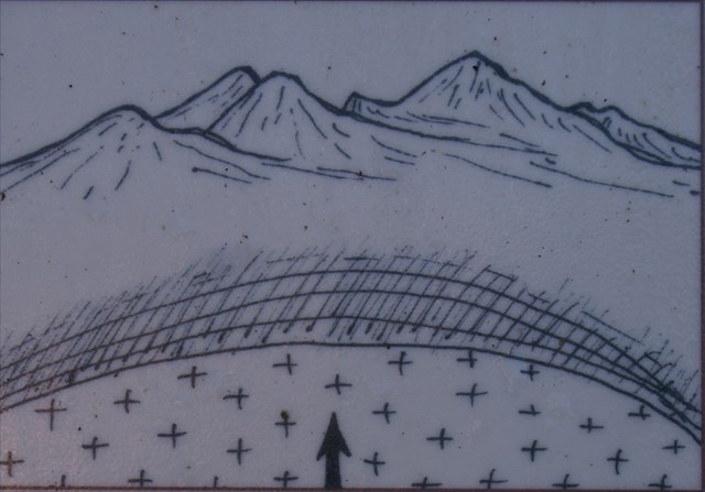
Granit appartient à la famille de la roche ignée. Granite commence comme un morceau de magma en profondeur. L'activité sismique lentement poussé le gros morceau de magma vers la surface de la planète. Bien que cela se produit, le magma cristallise lentement comme il se refroidit. Le granit dans ce domaine est évalué à 300 à 330millions d'années.
Granite belongs to the igneous family of rock. Granite starts out as a lump of magma deep underground. Seismic activity slowly pushed the large lump of magma up towards the surface of the planet. While this happens, the magma slowly crystallizes as it cools. The granite in this area is assessed to be 300 to 330 million years old.
Etape 2
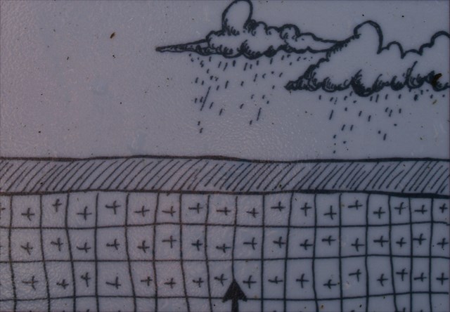
Sur une période de temps, la surface a été érodée par les intempéries, tandis que legranite sous-jacent s'est fracturé à la suite de mouvements tectoniques.
Over time, the surface has been eroded by the weather, while the underlying granite fractured as a result of tectonic movements.
Etape 3
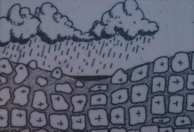
L'eau de pluie infiltrée dans les fissures, et l'expansion et la contraction saisonnière, aidé par l'érosion chimique du matériau, formé les rochers et a élaboré un bassin sous-jacent.
Rainwater seeped into the cracks, and the seasonal expansion and contraction, aided by chemical weathering of the material, formed the rocks and developed an under-lying basin.
Etape 4
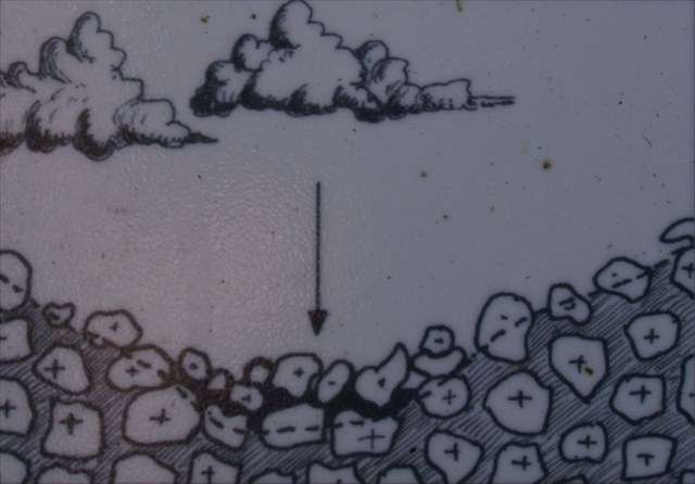
Enfin, le Blavet emporté les petits grains de granit et les sédiments. Les rochers exposés, roulaient sur la pente, et accumulés au fond de la vallée pour former le"Chaos".
Finally, the Blavet washed away the small grains of granite and sediments. The exposed rocks rolled down the slope and accumulate at the bottom of the valley to form the "Chaos".

Remerciements à l'Office du Tourisme Kreiz Breigh pour le mentorat cela EarthCache. Vous pouvez voir une vidéo d'une visite à Goulic Toul ici
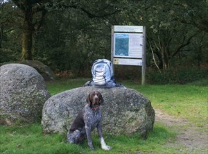
Pour réclamer ce cache, s'il vous plaît mesurer la profondeur verticale du ravin du haut de la roche derrière le chien dans la photographie au niveau de l'eau à l'emplacement du cache. Un sentier relie les deux positions, mais il pourrait être difficile d'utiliser un ruban à mesurer conventionnelle! Deuxièmement, en supposant que le ravin est en «V», 150m de large et 1km de longet, quel est le volume total de sédiments enlevés par le Blavet?
Envoyez votre réponses par email à la geocaching@juliadream.eu ou utilisez le lien Groundspeak pour réclamer votre trouvaille.
Lorsque vous visitez Toul Goulic, s'il vous plaît restez sur les sentiers et ne pas entrer dans toutes les zones marquées comme «propriété privée». S'il vous plaît respecter le code de Geocaching en laissant ce magnifique gorge propre et rangé.
Grateful thanks to the Office du Tourisme Kreiz Breigh for mentoring this Earth Cache. You can view a video of a visit to Toul Goulic here
To claim this cache, please measure the vertical depth of the ravine from the top of the rock behind the dog in the photograph to the water level at the cache location. A path links the two positions, but it might be difficult to use a conventional tape measure! Secondly, assuming the ravine is “V” shaped, 150m wide and about 1km long, what is the total volume of sediment removed by the Blavet?
Email your answers to geocaching@juliadream.eu or use the Groundspeak link to claim your find.
When you visit Toul Goulic, please stay on the paths and do not enter any areas marked as "Private Property". Please respect the Geocaching code by leaving this beautiful gorge clean and tidy.