Ball's Pyramid: World's Tallest Volcanic Stack EarthCache
Ball's Pyramid: World's Tallest Volcanic Stack
-
Difficulty:
-

-
Terrain:
-

Size:  (large)
Please note Use of geocaching.com services is subject to the terms and conditions
in our disclaimer.
Ball's Pyramid is the world's tallest volcanic stack. It is part of
the Lord Howe Island Marine Park, which is recorded by UNESCO as a
World Heritage Site of global natural significance. The pyramid
does not receive many visitors due to its remote location, but
scuba diving, sport fishing, and climbing are all available.
Ball's Pyramid is an erosional remnant of a shield volcano and
caldera that according to potassium-argon dating, (a technique that
determines the approxiamte age of something) formed about 7 million
years ago. It is located approximately 20 kilometres (12 mi)
southeast of Lord Howe Island in the Pacific Ocean. It is 562
metres (1,844 ft) high, while measuring only 1,100 metres (3,600
ft) in length and 300 metres (980 ft) across, making it the tallest
volcanic stack in the world.
Ball's Pyramid also has a few satellite islets. Observatory Rock
and Wheatsheaf Islet lie about 800 metres (2,600 ft) west-northwest
and west-southwest respectively, of the western extremity of Ball's
Pyramid. Southeast Rock is a pinnacle located about 3.5 kilometres
(2.2 mi) southeast of Ball's Pyramid. Like Lord Howe Island and the
Lord Howe seamount chain, Ball's Pyramid is based on the Lord Howe
Rise, part of the submerged continent of Zealandia.
Ball's Pyramid is composed of nearly horizontally-bedded basalt
lava flows, the remnants of a volcanic plug formed in a former vent
of a volcano. Basalt is a common rock that is typically formed by
melting of the Earth's mantle. Basalt has also been found on the
Earth's Moon, Mars, Venus, and even on the asteroid Vesta.
After the eruption of the shield volcano, the slopes became
truncated (top was removed) to form a broad submarine shelf (see
diagram below).
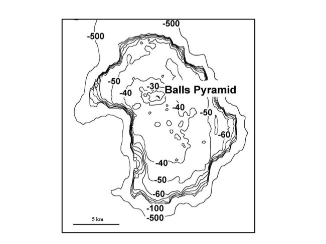
Ball's Pyramid is located in the centre of the shelf, which forms a
platform that is about 20 km from north to south, and averages 10
km wide. The average water depth above the shelf is around 50
metres. A similar but slightly larger shelf surrounds Lord Howe
Island, and the two platforms are separated by a canyon that
exceeds 500 m in depth. Eventually due to erosion by waves the
volcanoes will be completely gone, unless a coral reef forms around
it and protects its shoreline.
Ball's Pyramid is home to a small population of Lord Howe Island
stick insects, a species previously thought to be extinct. For
scuba divers, there is also the Lord Howe Island batfish only found
at this location.
To log this EarthCache, you must visit Balls's Pyramid in person
and answer the following questions:
1. What type of rock is basalt? (igneous, metamorphic,
sedimentary)
2. What is the prominent colour of the rock of Ball's Pyramid and
describe to me the physical appearance of the rock. (Examples could
be bubbles, crystals, striations, etc.)
3. How tall is Ball's Pyramid?
4. Why would the basalt that form's Ball's Pyramid remain when the
rest of the volcanoe is gone?
5. Basalt is typically formed by the melting of the Earth's
what?
6. Why do you think the formation of a reef around Ball's Pyramid,
(as continental plates slowly move it northward into reef forming
seas) would help to decrease erosion due to waves?
Pictures of you with Ball's Pyramid would be greatly
appreciated.
Sources:
www.wikipedia.com
http://serc.carleton.edu/vignettes/collection/35376.html
Additional Hints
(No hints available.)