|
Connection to the Earth Science Curriculum
Essential
Lessons:
1. How do currents
change the shape of Earth’s surface?
2. How can human
activities impact and accelerate these changes on Earth’s
surface?
Earth Science Literacy
Principles-
Big Idea 4.8 – Weathered and unstable rock
materials erode from some parts of Earth’s surface and are
deposited in others.
Big Idea 5.6 – Water shapes
landscapes.
Big Idea 9.5 – Human activities alter the natural land
surfaces
Common misconceptions
· Earth
has always been the way it is now.
· All
rocks are more or less the same
· The
Great Lakes were always here
· Rock
layers are always flat
Michigan State Science Content Expectations
Addressed:
· Grade
3- E.SE.E.2- Surface Changes- The surface of the Earth
changes. Some changes are due to slow
processes, such as erosion and weathering; and some changes are due
to rapid processes, such as landslides, volcanic eruptions and
earthquakes
· Grade
6- E.SE.M.4- Rock Formation- Rocks and rock formations bear
evidence of the minerals, materials, temperature/pressure
conditions, and forces that created them.
· Grade
6- E.ST.M.4- Geologic Time- Earth Processes seen today (erosion,
mountain building, and glacier movement) make possible the
measurement of geologic time through methods such as observing rock
sequences and using fossils to correlate the sequences at various
locations.
· High
School- E3.1c- Advanced Rock Cycle- Explain how the size and shape
of grains in a sedimentary rock indicate the environment of
formation (including climate) and deposition.
Vocabulary
moraine An area
of unsorted and angular rocks carried and deposited by glaciers at
the location where the ice melts.
outwash A
deposit of sand and gravel carried by running water from the
melting ice of a glacier and laid down in layered deposits.
albedo The fraction of Sun’s radiation
reflected from a surface.
katabatic winds A wind that carries high density air from a higher
elevation down a slope under the force of gravity
vernal ponds Temporary pools of water created by snow melt
and spring rains. The word ‘vernal’ refers to
‘occurring in the spring’.
Date Visited
July 11,
2011
|
Vernal Pools
at Redwyn’s
Dunes
EarthCache
Located on the coast of Lake Superior in the Keweenaw Peninsula,
Redwyn’s Dunes display evidence
of recent glaciations and forestation.
Visitors can observe vernal pools at this location created by the
unique geologic conditions present.
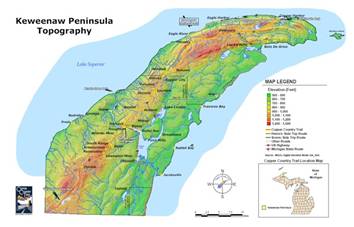
Figure 1. Keweenaw Peninsula Topography. Color map of the Keweenaw
Peninsula topography.
http://www.geo.mtu.edu/~raman/SilverI/MiTEP_ESI-1/Maps.html
Coordinates
N47°26.196’ W88°13.147’ (Trail Head)
N47°26.154’ W88°13.166’ (Waypoint)
Figure 2. Redwyn Dunes Google Earth
Waypoint. Jill
Weatherwax.
http://www.google.com/earth/index.html
Figure 3. Keweenaw Peninsula Eagle
Point. Google Earth. http://www.google.com/earth/index.html
Matertials Needed:
Metric Ruler, GPS, Hiking Shoes, Compass, Sketch Pad, Writing
Utensil
Sand
dunes can form anywhere there is sand and wind. Redwyn’s Dunes
are “perched dunes” which means they are located on a
surface higher than the lake surface.
They were formed approximately 10,000 years ago during the last
glacial recession of the Great Lakes.
Outwash sand deposits from the glaciers were left on the newly
exposed barren lands. This ground was
able to quickly heat up due to its low specific heat, causing
strong katabatic winds to form as the cold glacial air rushed
toward the warmer terrain nearby. These
winds blew sands and outwash up the glacial moraine forming the
perched Redwyn’s
Dunes. The dunes stabilized over time
as the winds became weaker and different species of plants and
animals moved into the area. Today you
can see this unique ecological system at Redwyn’s Dunes.
Perhaps
one of the most interesting habitats at Redwyn’s Dune are
the vernal ponds or pools located at the lowest elevations of the
dunes. These wetlands are temporary
small ponds of water that are dry for at least part of the
year. The vernal pools formed after
glaciers scraped away the most of the surface soils leaving the
bedrock close to the surface. Clay
layers and hard underlying bedrock impedes surface water
infiltration, creating conditions for water to pool and drain
slowly. The pooling can be at various depths throughout the
seasons, higher in the rainy season and after snow melt and lower
at other times of the year. Due to their concave shape and lack of
direct support of a permanent water table, they are often described
as “perched.”
The
unique geologic conditions that make vernal pools, also create unique communities of
organisms. These temporary pools are
home to many reptiles and amphibians.
Fish do not live in these ponds since they are not connected to
other water and sometimes dry up completely. Vegetation that is common here includes jack pine,
red pine ferns, reindeer moss and other various deciduous plants
that are well-adapted to the specific characteristics of vernal
pools. Many organisms associated with
vernal pools spend dry seasons as eggs, seeds, or cysts and then
grow and reproduce when the pool is again filled with
water.
The land
was cared for, in the past, by Native Americans who integrated
their culture into protecting these dunes. Today, people manage this land with rules that aim
to preserve the site and also meet the needs and wants of various
people and groups of people.
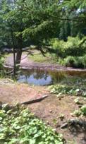
Figure 4. Vernal
Pond. Jill
Weatherwax.
Logging Questions-
Follow the trail system and answer the following questions along
the way:
- Describe the sediments found at Redwyn’s
Dunes. Sketch the color and shape of the
sediments you find.
- Describe and sketch at least two pieces of fauna you find near
the vernal pond
- Find the highest point of the dunes. What do you see from this vantage
point?
Access Information
This site is owned and managed by
The Michigan Nature Association and was given to the MNA via a
private donation by Mr. and Mrs. William Skora. Many of its features are named after
Skora
relatives and characters from novels Mr. Skora wrote.
Michigan Nature Association
326 E. Grand River Ave.
Williamston, MI 48895
(517) 655-5655
michigannature@michigannature.org
www.michigannature.org
References
Forgrave, Mike and Tricia (2011, August
6). Retrieved from
http://keweenawfreeguide.com/redwyns-dunes/
Michigan Nature Association (2011, August
6). Retrieved from
http://www.michigannature.org/
Rose, William (2011, August 6). Retrieved from
http://www.geo.mtu.edu/~raman/SilverI/MiTEP_ESI-1/Dunes.html
Schaetzel, R., Darden, J., & Brandt,
D. (Eds.). (2009). Michigan geography and geology. New York, NY: Custom Publishing.
Unknown. (2011, August 6).
Retrieved from
http://www.enotes.com/earth-science/dunes
Images
MIGOL Digital Elevation Model
24k-30m. Retrieved August 6, 2011, from:
http://www.geo.mtu.edu/~raman/SilverI/MiTEP_ESI-1/Maps.html
Redwyn Dunes Google Earth
Waypoint. Retrieved August 6, 2011, from:
http://www.google.com/earth/index.html
Tera
Metrics. (2009). Great Sand Bay -
OwlCr. [satellite image], Retrieved
August 6, 2011, from:
http://www.geo.mtu.edu/~raman/MiTEP-ESS-1/GreatSandBay-OwlCr.JPG
Weatherwax, J.
(Photographer). (2011). Vernal pond at redwyn’s dunes.
|