
Wichtig: Um alle Aufgaben loesen zu koennen muesst ihr einen Hammer mitbringen!
Vulkankegel Zeilberg
Aufschlussart: Basaltbruch 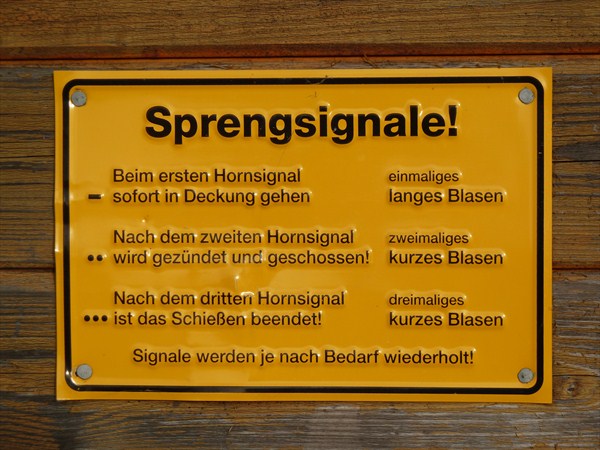
Geologie: Tertiaerbasalt und Tuffe mit dunklen Auswuerflingen (Dunit), metergroße Sandstein- und Kalk-Schollen und verschiedenste Mineralien in den Hohlraeumen des Basalt sowie in den Duniteinschluessen.
Status der Lagerstaette: in Betrieb – Da der Steinbruch noch in vollem Betrieb ist, sind unbedingt die Warnhinweise zu beachten! Das Betriebsgelaende darf nicht Betreten werden!
In den Haßbergen sind Muschelkalk, Keuper, Loess, Gips - und Sandsteinkeuper weit verbreitet deshalb ist der Basalt des Zeilberg, welcher durch Vulkanismus entstanden ist, eine Besonderheit in der Region.
Der Basaltbruch Zeilberg ist in Betrieb deshalb bleibt bitte auf den ausgeschilderten Wegen des Steinlehrpfads welcher um das Steinbruchgelaende herumfuehrt und beachtet unbedingt die Warnhinweise. Dort findet ihr auch Informationen und einen Multi rund um das Thema Steine.
Ein Meer auf dem Zeilberg?
Zu Beginn der Jurazeit, also vor 170 Millionen Jahren, bedeckte ein Meer fast ganz Europa uns somit auch unsere Landschaft.
Erdgeschichte 
Oestlich von Maroldsweisach steigt der Zeilberg 464 Meter steil empor und ueberragt knapp den Buechelberg mit 463 Meter westlich des Gemeindebereiches. Im Weisachtal neigt sich das Gelaende bis zu 300 Meter ueber Normalnull ab.
Vor 200 Millionen Jahren schichteten Wind und Wasser den roetlichen Sand des Trias zu Buntsandstein auf. Als dann im Jura vor 180 Millionen Jahren das Meer einbrach, lebten darin Massen von Ammonshoerner, Muscheln und Schnecken. Im Meerschlamm versteinerten die Tiergehaeuse. Wieder erhob sich der Meeresboden, das Meer trocknete aus. Dann schichteten Wind und Wasser im stetigen Wechsel Sand und Ton aufeinander und so entstand der Keuper unserer heimischen Landschaft.
Die Entstehung
Vor etwa 20 – 10 Millionen Jahren kam es im Gebiet des Vogelsberges und der der Roehn zu vulkanischer Taetigkeit.
Im Zusammenhang damit rissen in den Nord-Sued gerichteten Stoerungszone Spalten auf und fuellten sich mit Lava.
Die Geologen nennen dieses System „Heldburger Gangschar“.
**
Die Heldburger Gangschar
Die Heldburger Gangschar bezeichnet ein tertiaeres Vulkansystem in den fraenkischen Teilen Nordbayerns und Suedthueringens. Der Begriff Gangschar bezieht sich darauf, dass nur wenige der Vulkane heute noch als Oberflaechenform erhalten sind, indes ihre einstige Aktivitaet durch "Gaenge" genannte Spaltenfuellungen nachgewiesen werden kann. Diese Gaenge sind groeßtenteils in suedsuedwestliche Richtung ausgebildet, ihr Querschnitt betraegt oft weniger als einen Meter.
Lage der Heldburger Gangschar
Die Heldburger Gangschar stellt keine in sich geschlossene Landschaft dar und verteilt sich in der Hauptsache auf die naturraeumlichen Haupteinheiten Grabfeld, Itz-Baunach-Huegelland und Haßberge. Suedlich des Mains ist ihre einstige Aktivitaet jedoch auch im jeweiligen Norden von Steigerwaldvorland, Steigerwald und Fraenkischer Alb nachweisbar. Ihre Kernzone erstreckt sich von Hildburghausen im Nordnordosten bis Gerolzhofen im Suedsuedwesten, allerdings wird auch das deutlich oestlich dieser Linie gelegene Basaltvorkommen am Vulkan von Oberleinleiter im Norden der Frankenalb auf das Vulkansystem zurueckgefuehrt.
In einer dieser Spalten entstanden neben dem Zeilberg im Bereich des Naturparks Haßberge noch der Bramberg (Saeulenbasalt) und das Ostheimer Huegelhaeuschen. Die Gleichberge in Thueringen entstanden auch in diesem Zusammenhang.
Vulkan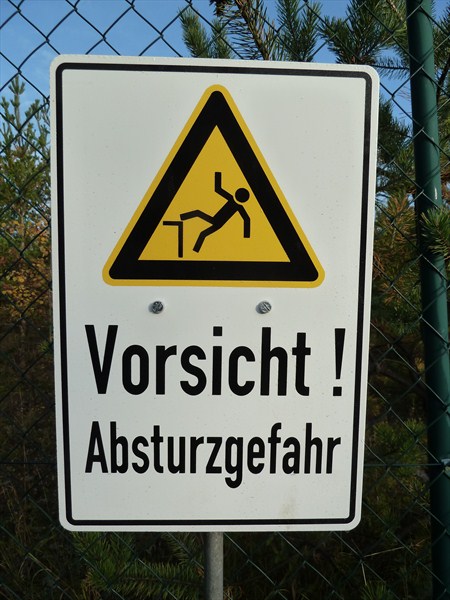
Ein Vulkan ist eine geologische Struktur, die entsteht, wenn Magma (Gesteinsschmelze) bis an die Oberflaeche eines Planeten (z.B. der Erde) aufsteigt. Alle Begleiterscheinungen, die mit dem Aufstieg und Austritt der glutfluessigen Gesteinsschmelze verbunden sind, bezeichnet man als Vulkanismus.
In einer Tiefe ab 100 km, in der Temperaturen zwischen 1000 und 1300 Grad Celsius herrschen, schmelzen Gesteine zu zaehplastischem Magma, das sich in großen, tropfenfoermigen Magmaherden in 2 bis 50 km Tiefe sammelt. Wenn der Druck zu groß wird, steigt das Magma über Spalten und Kluefte der Lithosphaere auf. Magma, das auf diese Weise an die Erdoberflaeche gelangt, wird als Lava bezeichnet.
Bei einem Vulkanausbruch werden nicht nur glutfluessige, sondern auch feste oder gasfoermige Stoffe freigesetzt (Vulkanismus). Die meisten Vulkane haben annaehernd die Form eines Kegels, dessen Hangneigung von der Zaehigkeit der Lava abhaengt. Die Gestalt kann aber auch unregelmaeßig sein oder eine kuppelfoermige Aufwoelbung bilden.
Der durch die vulkanische Aktivitaet entstandene Berg wird je nach seiner Form Vulkankegel oder Vulkandom genannt, und die Oeffnung, aus der Lava aus der Tiefe aufsteigt, heißt Vulkanschlot. Die mehr oder minder breite Oeffnung an der Spitze eines Vulkans ist der Vulkankrater. Bricht ein Schlot über einer oberflaechennahen Magmakammer zusammen, und es bildet sich ein großer Einbruchskrater, wird dieser als Caldera bezeichnet
Vulkankegel
Nachfolgend werden die bekanntesten erhaltenen Vulkankegel aufgefuehrt, in Klammern ihre Hoehe ueber NN und, falls bekannt, ihr geschaetztes Alter und ihr Gestein:
-
Großer Gleichberg (679 m, 15 Millionen Jahre, Alkaliolivinbasalt) – Grabfeld
-
Kleiner Gleichberg (641 m) – Grabfeld
-
Bramberg (495 m, 15 Mio. Jahre, Alkaliolivinbasalt) – Haßberge
-
Zeilberg (463 m, 16 Mio. Jahre, Nephelinbasanit) – Zeilberge im Itz-Baunach-Huegelland
-
Straufhain (449 m) – Itz-Baunach-Huegelland
-
Veste Heldburg (405 m, 12 Mio. Jahre, Phonolith und Olivintephritgang) – Itz-Baunach-Huegelland
Aeltere Vulkane wie der Vulkan von Oberleinleiter in der Fraenkischen Alb (31 Mio. Jahre, Olivinmelilithnephelinith und Olivinnephelinit) sind heute nicht mehr als Oberflaechenform erkennbar. So erreicht der letztgenannte zwar eine Hoehe von 505 m, ist jedoch vollkommen in die Juragesteine der Alb eingesenkt
Der Zeilberg
Der Zeilberg ist ein 463 m hoher Berg in Naturpark und Landkreis Haßberge im Osten Unterfrankens, etwa 2 km oestlich von Maroldsweisach. Er ist einer der wenigen heute erkennbaren Vulkane der Heldburger Gangschar und Namensgeber der Zeilberge, die als hoechster Teil des Itz-Baunach-Huegellandes nach Westen geologisch fließend, jedoch durch das Baunachtal abgetrennt, in die „eigentlichen“ Haßberge uebergehen.
Der Vulkan entstand vor 16 Mio. Jahren im Tertiaer und besteht aus Nephelinbasanit.
Tertiaer – 65 Mio. bis 2 Mio. Jahre vor heute Ausbreitung der Saeugetiere
vor 55 Mio. Jahren: Trennung von Australien und Antarktis
vor 38 Mio. Jahren: Kollision von Indien und Asien
vor 15 Mio. Jahren: Bildung des Himalaja; Oeffnung des Roten Meeres
Durch den Abbau im Basaltsteinbruch hat er bereits an Hoehe verloren.
*
Der Basalt 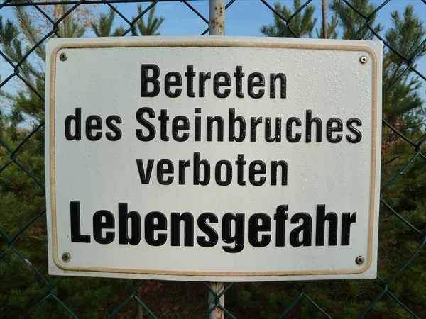
(16 Millionen Jahre alt) ist ein vulkanisches, meist grauschwarzes bis gruenschwarzes, dicht- bis feinkoerniges Gestein (Ergussgestein), mit oft zentimetergrossen Olivin-Einschluessen. Wenn Lava erkaltet, entstehen nicht selten mehreckige meterlange Basaltsaeulen (zu sehen im Basaltbruch Bramberg), die sich senkrecht zur Abkuehlungsflaeche bilden.
Alle Boeden der Weltmeere bestehen aus Basalt.
Basalt ist darueber hinaus ein haeufiges Gestein auf allen erdnahen Planeten (Merkur, Venus, Mars) und dem Mond.
Viele Meteoriten besitzen die gleiche chemische Zusammensetzung wie Basalt. Mit ihrer Hilfe koennen wir Rueckschluesse ueber die Entstehung unseres Sonnensystems ziehen.
Als Baustoff findet Basalt aufgrund seines druckfesten, schwer zu bearbeitenden aber nicht sproeden Charakters hauptsaechlich für den Unterbau von Strassen und Bahngleisen Verwendung.
**
Beantwortet bitte folgende Fragen vor Ort und sendet die Antworten an unser Profil.
Wichtig: Um alle Aufgaben loesen zu koennen muesst ihr einen Hammer mitbringen!
Loggen koennt ihr sofort, sollte etwas nicht stimmen, melden wir uns bei euch.
-
Am ersten Wegpunkt koennt und muesst ihr eure Kraefte messen Versucht mit dem mitgebrachten Hammer einen Gesteinsbrocken zu zerschlagen (es ist an dieser Station ausdruecklich erlaubt zu versuchen den Basalt zu zerschlagen, das koennt ihr an der Tafel nachlesen). Als Belohnung findet ihr vielleicht schoene Mineralien. Beschreibt in euren eigenen Worten a) den Basalt und b) euren Versuch des zerschlagens.
-
Nennt 2 der 4 Abgebildeten Mineralien im Basalt (QTA Wegpunkt)
-
Fertigt eine Zeichnung der Basaltsteine (QTA Wegpunkt) an. Es sollte dabei die charakteristische Form und Farbe des Basalt zu Erkennen sein.
-
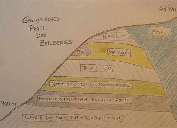
Anhand des "geologischen Profil des Zeilbergs" kann man sehen, dass der Zeilberg aus mehr als nur Basalt besteht. Weshalb sind diese Schichten nicht vulkanisch und wie sind diese entstanden?
-
Macht ein Foto von euch oder einem persönlichen Gegenstand vor dem Hintergrund des besuchten Ortes ohne zu spoilern und hängt dieses Foto an euren Log mit an. Dieses Foto ist eine Logbedingung welche auf grund der massenweise im Internet weitergegebenen EC Lösungen von mir gefordert wird. Logs ohne Foto werden nicht mehr akzeptiert.
Aufgrund der massenweisen Weitergabe von EC Lösungen im Internet stellen GSA und Groundspeak es den EC-Besitzern seit dem 10. Juni 2019 frei, ein Foto als Beweis für den Besuch vor Ort zu fordern. Ein Foto von sich selbst oder eines persönlichen Gegenstandes vor dem Hintergrund des besuchten Ortes ohne zu spoilern.
Ein Bild am Gipfelkreuz ist eine Bedingung zum Loggen.
* Quelle: Wikipedia Die Freie Enzyklopaedie ** Quelle: Tafel des Steinlehrpfades vor Ort
Important: In order to solve all tasks you need to take a hammer with you!
Volcanic cone Zeilberg
Digestion type: basalt quarry
Geology: Tertiary basalt and tuff with dark ejecta (dunite), meter-sized sand- and limestone flakes and various minerals in the cavities of the basalt and in the Dunite inclusions.
Status of the deposit: in operation - in operation - because of the quarry is still in full operation, the warnings must be observed! The premises must not be entered!
In the “Haßberge” limestone, keuper, loess, gypsum and sandstone is widespread therefore the basalt of the “Zeilberg” is a special feature in the region formed by volcanism.
The basalt quarry “Zeilberg” is in operation so please stay on the marked trails of the stone path which leads around the quarry site and observe the warnings. There you will also find information and a and a multi-cache on stones.
A sea on the Zeilberg?
At the beginning of the Jurassic period, 170 million years ago, a sea covered most of Europe are thus also our landscape.
Earth
East of Maroldsweisach the Zeilberg rises steeply 464 meters and dominates nearly the Buechelberg with 463 meters west of the municipal area. In the Weisachtal the terrain tends from the ground up to 300 meters above sea level.
200 million years ago - wind and water coated the reddish sands to the Triassic Sandstone on. Then in the Jurassic period 180 million years ago when the sea broke, it lived masses of ammonites, bivalves and gastropods in it. In the sea mud fossilized animal housing. Again rose the seabed, the sea dried up. Then in constant change wind and water coated sandy clay together the result was the Keuper of our local landscape.
The emergence
About 20 - 10 million years ago there where volcanic activity in the area of the Vogelsberg and the Rhoen. In connection with this in the north-south oriented fault zone columns torn up and were filled with lava. Geologists call this system "Heldburger Gangschar"
**
The Heldburger Gangschar
The "Heldburger Gangschar" refers to a tertiary volcanic system in Franconia in northern Bavaria and parts of southern Thuringia. The term "Gangschar" refers to the fact that few of the volcanoes are still preserved as surface shape, while their former activity by "transitions" called fissure fillings can be detected. These courses are mostly trained in SSW direction, its cross-section is often less than one meter.
Location of the „Heldburger Gangschar“
The "Heldburger Gangschar " is not a self-contained landscape and distributed mainly to the major biogeographic units "Grabfeld, Itz-Baunach-Huegelland" and the “Haßberge”. South of the River Main, her former activity is also relevant in the northern foothills of the “Steigerwald”, the “Steigerwald” and Franconian Alb detectable. Their core zone extends from “Hildburghausen” in the northeast to “Gerolzhofen” in south-southwest but also the further east east of this line located basalt at the volcano of “Oberleinleiter” in the north of the Franconian is attributed to the volcanic system.
Volcano
A volcano is a geological structure that is formed when magma (molten rock) to the surface of a planet (eg earth) rises. All side effects associated with the rise and exit of molten rock is known as volcanism.
Prevail at a depth of 100 km, in the temperatures between 1000 and 1300 degrees Celsius, to melt rocks viscoplastic magma that accumulates in large, teardrop-shaped magma herds in 2 to 50 km depth. When the pressure becomes too great, the magma rises through cracks and crevices on the lithosphere. Magma that reaches the earths surface in this way is called lava.
During a volcanic eruption not only molten, but also solid or gaseous substances are released (volcanic activity). Most volcanoes have approximately the shape depends on a cone, the slope of the viscosity of the lava. The shape can be irregular or form a dome-shaped bulge.
The mountain caused by the volcanic activity, is called vulcanic dome or volcanic cone depending on its form , and the opening in which the lava is rising from the depths, is called a volcanic vent. The more or less wide opening at the top of a volcano is the volcanic crater. Collapses a volcanic vent above a close to the surface located magma chamber and forms a large crater collapse it is called a Caldera.
Volcanic cone
Below are the most famous preserved volcanic cones listed in parentheses their height above sea level and, if known, its estimated age, and its rocks:
-
Großer Gleichberg (679 m, 15 million years, Alkaliolivinbasalt) – Grabfeld
-
Kleiner Gleichberg (641 m) – Grabfeld
-
Bramberg (495 m, 15 million years, Alkaliolivinbasalt) – Haßberge
-
Zeilberg (463 m, 16 million years, Nephelinbasanit) – Zeilberge at the Itz-Baunach-Huegelland
-
Straufhain (449 m) – Itz-Baunach-Huegelland
-
Veste Heldburg (405 m, 12 million years, Phonolith and Olivintephritgang) – Itz-Baunach-Huegelland
Older volcanoes such as the volcano of “Oberleinleiter” in the Franconian Albs (31 million years, Olivinmelilithnephelinith and Olivinnephelinit) are now no longer recognizable as the surface shape. Although it reaches a height of 505 m, but it sunk in the Jurassic rocks of the Alb completly.
The Zeilberg
The “Zeilberg” is a 463 m high mountain at the park and district “Haßberge” in the east of Lower Franconia, about 2 km east of “Maroldsweisach”. It is one of the few visible volcanoes in the "Heldburger Gangschar" today and namesake of the “Zeilberg” which is the highest part of the "Grabfeld, Itz-Baunach-Huegelland" geologically westward flowing, but separated by the "Baunachtal", passing to the "real" Haßberge.
The volcano was formed 16 million years ago in the Tertiary and consists of Nephelinbasanit.
Tertiary - 65 million to 2 million years before present:
Spread of mammals
55 million years ago: separation of Australia and Antarctica
38 million years ago: collision of India and Asia
15 million years ago: formation of the Himalayas; opening of the Red Sea
By degradation in the basalt quarry it has already lost altitude.
*
The basalt
(16 million years old) is a volcanic, mostly gray-black to greenish black, dense to fine-grained rock (volcanic rock), often with centimeter-large olivine inclusions. When lava cools, often creates more square yards of basalt columns (see the basalt quarry Bramberg) that form perpendicular to the cooling surface.
All grounds of the oceans are made of basalt.
Basalt is also a frequent rock on all near-Earth planets (Mercury, Venus, Mars) and the moon.
Many meteorites have the same chemical composition as basalt. With their help, we can draw conclusions about the origin of our solar system.
When building basalt is due to its pressure-resistant, difficult to work but not brittle character mainly for the substructure of roads and railway lines used.
**
Please answer the following questions and send the answers to our profile.
Important: In order to solve all tasks you need to take a hammer with you!
You can log your visit without waiting for our o.k. to log, if something is wrong we will contact you.
-
At the first waypoint you have to measure your powers. Try to smash a basalt rock buck with the hammer you have to take with you. As a reward, you may find beautiful minerals. Describe in your own words a) the basalt and b) your attempt to smash. You can read on the blackboard that at this point it is explicitly permitted to try to smash a basalt rock buck.
-
Call 2 of the 4 depicted minerals in the basalt (QTA waypoint).
-
Create a drawing of the basalt stones (QTA waypoint). It should show the characteristic shape and color of the basalt stones.
-
Using the "geological profil of the Zeilberg" you can see that the Zeilberg consists of more than only basalt. Why are these layers not volcanic and how they were created?
- Take a photo at the place and add it to your log as a proof of your visit.
A picture at the mountain cross is a condition to log.
* Source: Wikipedia The Free Encyclopedia ** Source: Panel of local stone trail