(Original Description Circa 2002)
Somewhere in Orangeville Ontario is a nest of six geocache travel bugs but a virus has presented itself within the nest. Somehow an infected monkeycache.com migrating monkey has found its way into the nest (See pictures). The monkey's virus is a powerful and deadly disease. The geocache travel bugs must be saved.
Your mission is to quickly find the nest and rescue one geocache travel bug. The travel bug will survive if it’s placed in another cache within 3 days. The other cache will have enough positive energy to rid the travel bug of any residual harm and save the world from a disaster. Your adventure begins with:
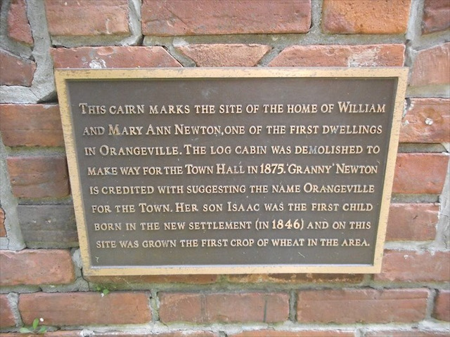
Stage One - The Virtual Cache - This site is found at the co-ordinates listed above. It will bring you to the location of one of Orangeville’s first dwellings. Record in the space below the year that the dwelling had changed.
___ ___ ___ ___
a b c d
There is no actual container at this location (that’s why it’s virtual). The difficulty and terrain rating of this stage is 1/1.
(Update 2021) - The coordinates will take you to a monument. Sadly, it has been damaged and the original brass plaque is gone. Use the image below to gather the information you seek.
Stage Two – The Micro Cache – The Micro Cache is located at S 98’00.789 and E535’50.104. Use the co-ordinate decryption code below:
N E 1 2 3 4 5
--------------
S W 6 7 8 9 0
If the outbreak were to occur, stage 2 displays the type of fire power the world will need to use to regain control. The micro cache is located 22.5m from stage one but be careful not to electrocute yourself one the way. Record the 5 digit number as indicated by the micro cache.
___ ___ ___ ___ ___
e f g h i
This container is 1.5” in diameter and 2” tall. The difficulty / terrain of this stage is 3/1. 2002 Update: In recent months Cedardoggy has had to replace the micro cache many times. If this stage is missing when you arrive, use the hint below for instructions to stage three.
(Update 2021) The micro cache is too difficult to maintain at this site, use this information to continue your adventure. Find the REG. number and record it above. Cache 3 is found at North forty three° 53.678 / West eighty° 06.683
Stage Three – The Mystery Cache – The co-ordinates to this cache are found in the micro cache. This cache will take you up but never let you down. Record the 3 digit number found at this site in the space below.
___ ___ ___
j k l
You are looking for something not normally associated with geocache containers. The difficulty and terrain rating of this stage is 3/3.25
(Update 2021) This section requires you to summon your inner billy-goat. Climb high and get the last set of numbers.
Stage Four – The Offset Cache – By definition an offset cache is one located near the co-ordinates given. In this case the ‘nest’ is nearby. The co-ordinates to this cache are revealed up by using the recorded clues given in the previous 3 stages. Simply match the numbers and letters to reveal the final set of co-ordinates.
N ___ ___ º ___ ___ . ___ ___ ___
j k º d k . d d a
W ___ ___ ___ º ___ ___ . ___ ___ ___
l b l º l f . i e j
This container is an ammo box 4” x 11” x 7”. The difficulty is rated 4 due to the unique hiding spot of this cache. The terrain on this stage is also rated 4 due to an overgrown forest with a barely defined trail.
The co-ordinates will bring you to a clearing on top of a hill. The nest is well hidden but look for the cluster of 4 birch trees. One of the trees will have a rope tied to it. The actual cache will be revealed when you unhook the rope and let it out slowly. It is not necessary to untie any of the knots.
For the first 7 geocachers: Please take one travel bug. In the interest of fair play and good sportsmanship please allow 6 other geocachers to share in the thrill of finding and moving a travel bug. Also remember to bring something to replace the travel bug otherwise the cache will be empty once the bugs are gone. There is one Ziploc bag in the cache which stays with the cache. You will find a logbook and camera inside. Please take a picture of you or your team with the travel bug you are taking. Once the bugs are gone please take a picture of you with the cache.
This cache can be done all year round. Remember stage 4 is best done with proper footwear and clothing for hiking.
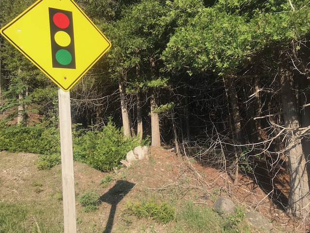
(Update 2021) Enter the forest near 3rd cache. Finding this sign nearby will help. (Note: the most direct route is unsuitable due to swampy terrain). Climb up the hill and stay on the ridge until you are very close to the coordinates - this route will require the least bushwhacking. The cache is down one side of the ridge 15-20ft and hanging from a birch tree 3-4ft off the ground. It is in your interest to bring appropriate bug protection.
On June 6, Westwinds and the next generation (kids 8yo and 10yo) found the original geocache. Inside were several original items including the logbook, pencils and travel bug description cards. It was a unique experience being back there after 20 years and to watch the excitement in their eyes as they are introduced to Geocaching. It took us 114min from the time we found the first coordinates to when we returned from the forest to our vehicle. This included usual geocaching situations and delays along with some time to photograph every page of the original logbook.
We added a new logbook (leaving the original), several more goodies and one more trackable for good measure.
Enjoy this one and have fun. Westwinds and the next Generation
All references to virus, disease or infection are purely for dramatic effect.
As of June 11, 2021 this cache was #205 of Canada's oldest and still active caches
As of June 11, 2021 this cache was #73 of Ontario's oldest and still active caches