Saint Sauveur Traditional Cache
-
Difficulty:
-

-
Terrain:
-
Size:  (small)
Please note Use of geocaching.com services is subject to the terms and conditions
in our disclaimer.
À une altitude de 1200 mètres au chef-lieu, la commune regroupe 17 hameaux à flanc de montagne. Depuis ce chef-lieu, il est possible d'admirer nombre des sommets alentours, le Pouzenc, le Grand Morgon, les Aiguilles de Chabrières, le mont Guillaume et le panorama incomparable sur la vallée Embrunaise avec le lac de Serre Ponçon.
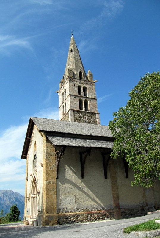
Attardez-vous près de l'église de la Transfiguration construite au 15ème siècle. Le clocher a été classé aux monuments historiques en 1949. Elle est dotée d'un auvent (restauré) initialement destiné à protéger les peintures des murs extérieurs.
A l'intérieur, elle possède de superbes fresques très récemment restaurées aussi, tout comme l'ensemble de sculptures et de peintures de l'arc triomphal.
Se renseigner à la mairie sur la possibilité de visiter l'église.
[Eng] Located on a mountainside at an altitude of 1200 meters in the chief place, the municipality gathers 17 hamlets. From this chief place, enjoy many of the surrounding peaks, the Pouzenc, the Grand Morgon, the needles Chabrières, Mount William and the incomparable view over the valley and the lake of Serre Ponçon. Take time to watch the Church of the Transfiguration built in the 15th century. It has a restored canopy, originally designed to protect the the exterior walls decorated with paintings. Inside, it has beautiful frescoes, recently restored too, as well as all of sculptures and paintings of the triumphal arch. The steeple has been classified as historical monument in 1949.
Additional Hints
(No hints available.)