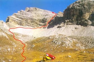
 [ITA] "Piz Duleda - Via ferrata" Dal parcheggio della strada forestale si cammina inoltrandosi nel bosco su una leggera salita che conduce alla Malga Ciancenon/Tschantschenon Alm. Da qui si prosegue fino alla Forcella de Furcia/Kreuzjoch su una salita più o meno ripida, e poi in leggero saliscendi fino alla Forcella de la Roa/Roa-Scharte.
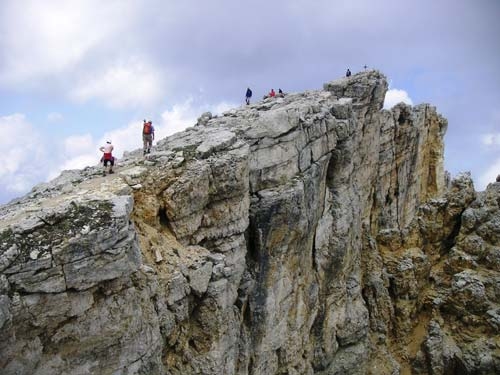
... si snodano nuove ripide serpentine che conducono sulla Forcella de la Roa/Roa-Scharte e procedendo a sinistra, su un terreno pianeggiante, si raggiunge la ferrata assicurata (segnaletica come segue: alla Forcella de Nives/Nives-Scharte passando per la via ferrata). La ferrata non è esposta (non richiede arrampicata, solo salita), è ben assicurata, ma a causa della friabilità della roccia richiede un passo sicuro.
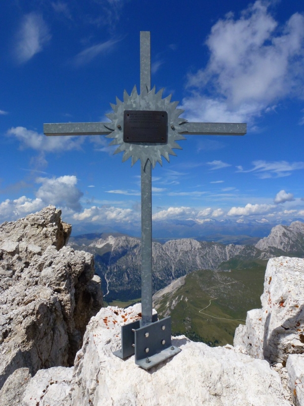
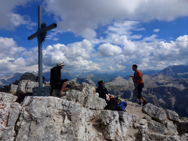
Tramite una scala (ca. 2 m) si supera un gradino roccioso, per raggiungere poi la Forcella de Nives/Nives-Scharte. Su un terreno in parte caratterizzato da detriti e da prato, si segue la salita, non più difficoltosa, fino alla vetta. Il panorama è meraviglioso, la vetta esposta offre una vista “a precipizio”, prevalentemente caratterizzata da nebbia in ascesa.
-
Gruppo montuoso: Puez - Odle
-
Tragitto: Bressanone - Val di Funes
-
Punto di partenza: albergo Sas Rigais presso la Malga Zannes/Zanser Alm (1.689 m)
-
Salita: sentiero n° 32, n° 33, n° 3, o Alta Via delle Dolomiti, segnavia n° 2c
-
Tempo di percorrenza: 3 - 4 ore
-
Dislivello: ca. 1.300 m
-
Discesa: vedi salita
-
Tempo di percorrenza totale: 6 ore
-
Grado di difficoltà: medio
 [DEU] "Piz Duleda - Klettersteig" Vom Parkplatz auf dem Forstweg gerade aus in den Wald, sanft ansteigend zur Tschantschenon Alm, dann steiler bis steil aufs Kreuzjoch, von dort in leichtem Ab- und Aufstieg zur Roa-Scharte.
... in wieder steileren Serpentinen auf die Roa-Scharte und flach nach links queren zum gesicherten Steig (Beschilderung folgend: zur Nives-Scharte über Klettersteig). Steig nicht exponiert (kein Klettern, sondern nur Steigen), gut gesichert, Trittsicherheit aufgrund des brüchigen Gesteins vorteilhaft.
Eine kleine Felsstufe überwindet man mittels einer Leiter (ca.2m), und schon erreicht man die Nives-Scharte. Über Geröll und wiesenartiges Gelände folgt der nicht mehr schwierige Aufstieg auf den Gipfel. Super Panorama, der Gipfel ist ausgesetzt und gibt Blicke in den Abgrund frei, meist aufsteigende Nebel.
-
Gebirgsgruppe: Puez - Geisler
-
Anfahrt: Brixen - Villnösstal
-
Ausgangspunkt: Hotel Sas Rigais bei Zanser Alm (1689 m)
-
Aufstieg: Weg Nr. 6, Kreuzjoch,Weg Nr. 3 bzw. Dolomitenhöhenweg, Weg 3A Piz Duleda
-
Gehzeit: 3 - 4 Stunden
-
Höhenunterschied: ca. 1300m
-
Abstieg: wie Aufstieg
-
Gehzeit gesamt: 6 Stunden
-
Schwierigkeit: mittlere
 [ENG] "Piz Duleda - Secured Climbing Trail" From the parking lot, proceed along the forest trail straight ahead into the forest. Continue along the slight uphill grade until you reach the Tschantschenon/Ciancenon Alm. It gets steeper as you approach Kreuzjoch / Passo Furcia. From there, the trail goes up and down until you get to the Roascharte / Forcella Roa.
… the trail becomes more serpentine and steeper as you approach the Roascharte / Forcella Roa. Take the level turn to the left to get to the secured climbing trail (follow the sign reading "zur Nives-Scharte über Klettersteig" = to the Nives Gap via secured climbing trail). The climbing trail is not exposed (you won't have to scale the mountainside, but only ascend on foot) and is well-secured. Because of the crumbly, rocky surface, sure-footedness is an advantage.
You will have to scale a small (approx. 2-meter-high)rocky step using a ladder. You have now reached the Nives Gap. The terrain is covered with rubble and occasional meadow-like patches. The rest of the way to the summit is no longer very difficult. You will be able to enjoy a magnificent panoramic view. The summit is exposed and affords a look right down into the abyss, out of which fog rises much of the time.
Group: Puez - Geisler
Arrival: Brixen/Bressanone – Villnoesser Valley / Val di Funes
Starting-point: Hotel Sas Rigais near the Zanser Alm (1,689 m above sea-level)
Ascent: Trail No. 32, Trail No. 33, Trail No. 3 or the High Dolomite Trail, Trail No. 2c
Duration: 3 - 4 hours
Altitude differential: approx. 1,300 m
Descent: like the ascent
Total round-trip time: 6 hours
Level of difficulty: medium