Velký Sokol / Róthova roklina
Najmohutnejšia a najdivokejšia roklina v Slovenskom raji
The most robust and wildest ravine in Slovak paradise
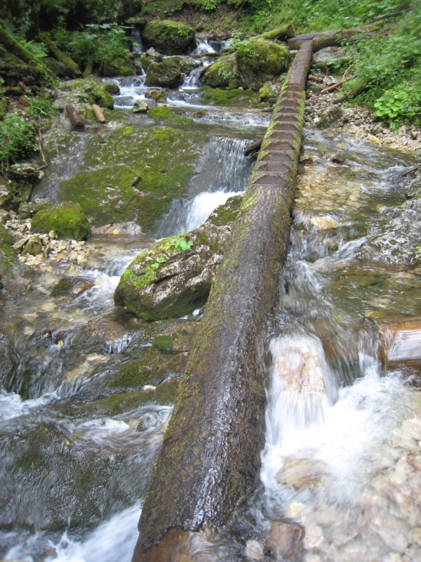
SK: Velký Sokol je mohutná a dlhá tiesnava na západnom okraji planiny Glac. Ukoncuje ju romantická Róthova roklina, ktorá je pomenovaná po jednom z priekopníkov turistiky v Slovenskom raji Martinovi Róthovi, profesorovi gymnázia v Spišskej Novej Vsi. Profesor Róth uskutocnil úplne prvý prechod rokliny Velký Sokol dna 20.8.1898 spolu s N. Filarským a M. Karolinym. Jednalo sa o prvý turistický prechod rokliny Slovenského raja. O mesiac neskôr tá istá skupina doplnená umeleckým fotografom V. Forbergerom prešla tiesnavou druhýkrát. Fotografie V. Forbergera boli prvými zábermi z tiesnav Slovenského raja. Roku 1956 namontovali clenovia Horskej služby v tiesnave prvé kovové rebríky.
V porovnaní s inými tiesnavami Slovenského raja, Velký Sokol vyniká svojou mohutnostou a divokostou. Oba brehy tiesnavy vytvárajú skalné svahy casto až 300 m vysoké. Prevýšenie rokliny je 289m na dlžke 6 km. Velký Sokol je súcastou národnej prírodnej rezervácie Sokol s piatym, najvyšším stupnom ochrany.
(Zdroj: www.slovenskyraj.sk)
Geomorfologický vývoj Slovenského raja zacal v neogéne. Povrch Slovenského raja v tomto období nemal horský charakter. V tomto období sa v tejto oblasti už nachádzali niekolko sto metrov hrubé usadeniny druhohorného mora ( staré cca 220-200 miliónov rokov). More sa nazývalo Tethys a po dobu viac ako 100 miliónov rokov nazhromaždilo na svojom dne niekolko kilometrov mocné usadeniny organického bahna so schránkami morských živocíchov a rastlín. Usadeniny sa pod vlastnou váhou spevnili do mohutných vrstiev vápencov a dolomitov. Reliéf krajiny bol plochý. Neexistovali ešte nijaké kanony a tiesnavy, ktoré sú pre dnešné územie také charakteristické. Vtedajšie rieky tiekli v podstate po rovnom povrchu. Takýto charakter povrchu územia trval do doby stredného pliocénu (asi pred 4 mil. rokmi), v ktorom nastalo silné zvrásnenie. Zdvihlo sa i územie Slovenského raja a na druhej strane klesla Hornádska kotlina. Rieky a potoky zväcšili svoj spád a zacali sa prudko zarezávat do plochého, väcšinou vápencového podkladu.
Z chemického hladiska je základom krasových javov reakcia vzdušného oxidu uhlicitého s vodou za vzniku slabej kyseliny uhlicitej. Málo koncentrovaná kyselina postupne preniká puklinami vápencov a rozrušuje ich. Okrem chemickej erózie prebieha aj erózia mechanická spôsobená samotnou vodou, ktorá preniká do puklín a rozrušuje štruktúru horniny. V zime je tento vplyv umocnený faktom, že lad má v porovnaní s vodou väcší objem, v dôsledku coho v puklinách vznikajú mechanické sily pôsobiace deštruktívnym spôsobom na kamen. Mechanická erózia je podporovaná aj vegetáciou, ktorá zadržiava vodu a okrem toho rozrušuje horninu svojimi korenmi. Chemické a mechanické rozrušenie horniny neustále postupuje a umožnuje tak vytvárat krajinné prvky, ktoré majú neraz velmi bizarné tvary.Takmer každý vodný tok v Slovenskom raji takýmto spôsobom vyerodoval do svojho dna zaujímavý kanon alebo roklinu s vodopádmi prekonávajúcimi skalné prahy.
Turistické informácie:
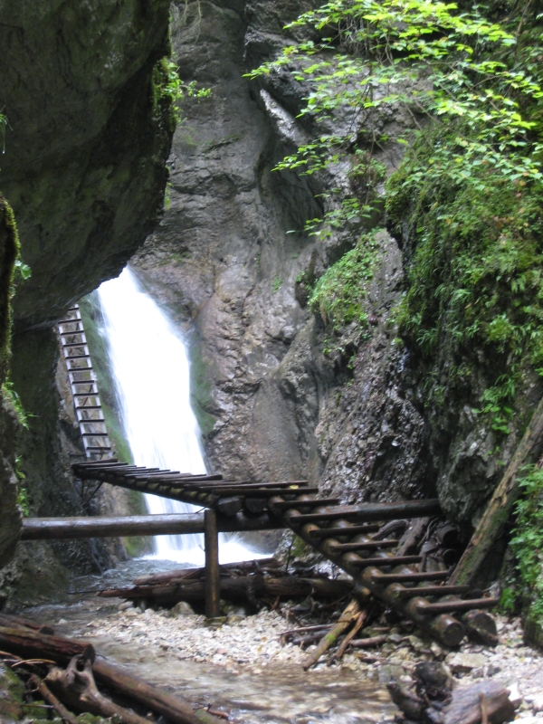
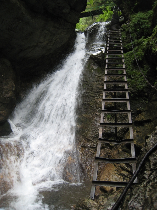
Ústie rokliny je prístupné z osady Píla nachádzajúcej sa na severozápadnom okraji Slovenského raja. Samotnou roklinou prechádza žlto znackovaný turistický chodník. Cas prechodu je cca 2,5 hodiny.
Upozornenie:
Roklina je v exponovaných miestach zabezpecená rebríkmi, lávkami a retazami. Jej prechod si vyžaduje pevnú obuv a je možný zásadne len jedným smerom - zdola nahor. V prípade nepriaznivého pocasia alebo vysokého stavu vody sa môže priemerný cas prechodu výrazne predlžit.
Podmienka pre uznanie logu:
Je potrebne splnit nasledujúce úlohy a poslat správne odpovede e-mailom ownerovi (použite údaje z profilu). Pri nesplnení bude log vymazaný. Prosím nepíšte správne odpovede do logu.
- Odhadnite šírku tiesnavy Velký Sokol v jej kanonovitom useku na jej najužšom a najširšom mieste.
- Odhadnite šírku Rothovej rokliny na jej najužšom a najširšom mieste.
- Porovnajte velkosti oboch roklín. Popíšte vlastnými slovami, co je podla Vášho názoru prícinou rozdielu .
EN: Velky Sokol is a robust and long ravine at the western end of the Glac plateau. At the end of the ravine, there is situated the Róth ravine, named after one of the most famous Slovak Paradise guide Martin Róth who was a professor of the secondary school in Spisska Nova Ves. Professor Róth performed the first tour through the ravine Velky Sokol on August 20, 1898 with Dr. N. Filarský and M. Karoliny. It was the first hike through the gorge of Slovak Paradise. One month later the same group enhanced with the art photographer, Mr. R. Forberg, overpassed the ravine for the second time. Mr. Forberg´s photos were the first photos of the Slovak Paradise ravines. In 1956, the Mountain Rescue Service members put the first metal ladders into the ravine.
In comparison with the other ravines of Slovak Paradise, Velky Sokol stands out with its robustness and wildness. Both banks of the ravine have the shape of very steep stone walls that are up to 300 m high. The superelevation of the gorge is 289m on the length of 6 km. Velky Sokol is a part of Sokol national natural reservation with the fifth, highest level of the protection.
(Source: www.slovenskyraj.sk)
The process of evolution of Slovak Paradise started in neogen. Landscape of the Slovak Paradise in that time didn’t have mountain character. At that time there were several hundred meters thick sediments of Mesozoic’s sea (approx. 200-220 million years old). The sea was called Tethys and during more than 100 million years period it gathered several kilometres thick sediments of organic mud with shells of sea animals and plants at its bed. These sediments were strengthened to huge stone beds of limestone and dolomites under the influence of its own weight. Relief of the landscape was flat. There were no canyons and ravines, so characteristic for today’s landscape. The rivers in that time flew on practically flat surface. This landscape character remained till the middle pliocen (4 mil. years ago) whe the landscape was wrinkled. The land of Slovak Paradise lifted up and in the same time the land of surrounding Hornadska kotlina territory dropped down. Rivers and streams heightened their gradient and started to penetrate to flat limestone basement.
From the chemical point of view the base for carst phenomenon is reaction of air carbon dioxide with the water resulted to creation of sparse carbonic acid. Low concentrated acid penetrates piecemeally through rifts in limestone rock and destroys it. Except of chemical erosion, also mechanical erosion caused by the water itself is in the progress. Water penetrates to the rimes and destroys the structure of rock. During winter this influence is strengthened by the fact that ice has bigger cubature as water. Because of this the mechanical forces results in the rimes with the destructive effect to the stone. The mechanical erosion is also supported by the vegetation which keeps water and also destroys stones by its roots. Chemical and mechanical erosion of the rock permanently proceedes and creates landscape elements of the bizarre shapes. By this way nearly every water flow in Slovak Paradise made as a result of bed erosion interesting canyon or ravine with waterfalls fetching through rock brims.
Tourist information:
The start point of the ravine is accessible from the Píla village placed on the north-west part of Slovak Paradise. Ravine itself is passed by yellow marked tourist path. The crossing time is approx. 2,5 hours.
Attention:
The gorge is at dangerous places secured by technical aids - ladders, bridges, chains. It is possible to walk alongside the gorge only from below upstream and you need appropriate equipment including firm hiking boots. The estimated travel time of hiking tour can be significantly prolonged due to bad weather conditions or high water level.
Conditions for accepting your log:
It is necessary to fill following tasks and to send correct answers to owner’s e-mail (Use information from profile). If you didn’t fulfill tasks, your log would be deleted. Please don’t write correct answers to your log.
- Estimate the cross size of the Velky sokol canyon on its narrowest nad widest place.
- Estimate the cross size of the Rothova roklina ravine on its narrowest and widest place.
- Compare the sizes of both ravines. Explain using your own word, what is according your opinion cause of difference.