
Le cycle hercynien
Le cycle hercynien est responsable de la formation de la chaîne de montagnes appelée chaîne hercynienne (ou chaîne armoricaine, ou encore chaîne varisque) par la collision des supercontinents Euramérique (ou Laurussia, aujourd'hui: l'Amérique du Nord, Mexique, Grœnland et Grande Bretagne) et Gondwana (aujourd'hui: l'Afrique, l'Amérique du Sud, l'Australie, l'Inde, l'Arabie, l'Antarctique et les Balkans) il y a 300 à 400 million d'années. Après le mouvement tectonique depuis des millions d'années, on retrouve aujourd'hui le résultat du cycle hercynien sous la forme des Appalaches aux États-Unis et en tant que chaîne hercynienne Européenne. Si cela vous intéresse, vous trouvez des informations plus détaillées ici.
Chaîne hercynienne Européene: La Corse
La Corse hercynienne occupe les deux tiers de l’île. Ce socle cristallin est constitué de roches plutoniques (granites, diorites, gabbros) et d’un complexe volcanique rhyolitique. Ce massif hercynien qui s’allonge du NO au SE est dissymétrique, les longues pentes à l’est contrastant avec la retombée brutale sur le bas pays à l’ouest, en liaison probable avec le contrecoup hercynien. Vous trouvez plus d'informations sur la géologie de la Corse ici.
Aspect géologique actuel
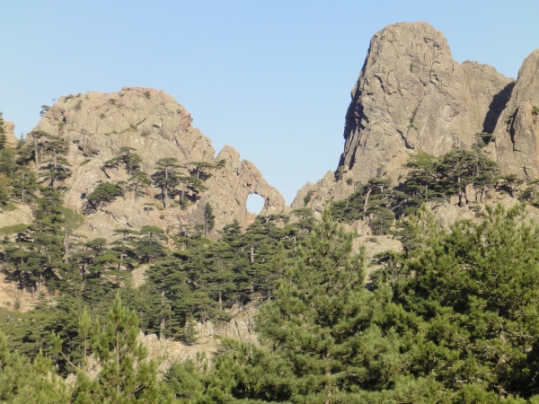
Pendant que les parties plus basses du massif protégées par la végétation ont gardé leur forme, les parties émergeantes des montagnes ont été ablatées par l'érosion (pluie, courants, gel, chaleur) depuis le cycle hercynien et donnent ainsi l'aspect actuel que vous pouvez observer. On trouve un effet particulier de l'érosion dans une partie de la chaîne hercynienne de la Corse, le massif de Bavella : "Le trou de la bombe" en Français ou "U tafunu diu cumpuleddu" en Corse.
La raison de cette formation c'est que la roche granitique compacte qui semble être d'une composition uniforme s'est érodée très irrégulièrement, donnant naissance à des cavités. Des différences presque indétectables de la structure de la roche sont à l'origine de ce phénomène. La strate plus souple s'érode plus rapidement tandis que la roche plus dure qui resiste plus à l'érosion va former le trou.
La cache
Vous arrivez au trou de la bombe par une randonnée d'un peu plus d'une heure (simple). Nous vous conseillons de démarrer la ballade au parking à coté de la D268 (N 41° 47.740 E 009° 13.480) à proximité de l'Auberge du Col de Bavella, en suivant le chemin avec les balisages rouges. Faites attention à ne pas rater le passage au point N 41° 46.753 E 009° 14.118. Le trou n'est presque pas visible de ce point!
On vous recommande de passer en chemin à la cache GC147ZE: La Bomba d'ou vous avez une magnifique vue sur le trou de la bombe.
Trouvez ce phénomène naturel et répondez aux questions suivantes:
1. Quel taille a le diamètre du trou?
a. 4 m
b. 8 m
c. 16 m
d. 32 m
2. De quoi est constituée la roche dans laquelle se trouve le trou?
a. Basalte
b. Schiste
c. Granit
d. Grès
3. Comment le trou s'est-il formé?
a. Volcanisme
b. Tremblement de terre
c. Bombe de la deuxième guerre mondiale
d. Érosion
et envoyez une e-mail à tafunu.réponse1réponse2réponse3@googlemail.com, par exemple tafunu.abc@googlemail.com (ce n'est qu'un exemple!)
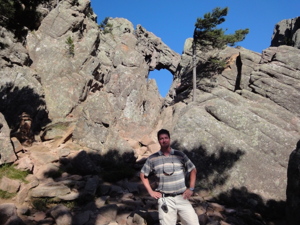
Merci de prendre une photo de vous ou votre unité de GPS devant le "Trou de la bombe" au point N 41° 46.745 E 009° 14.135 (voir exemple ci-dessous) et télécharger la photo avec votre log.

Variscan orogeny
The Variscan (or Hercynian) orogeny is a geologic mountain-building event caused by a collision 300 to 400 million years ago between the northern supercontinent Euramerica (today: North America, Mexico, Greenland and Great Britain) and the southern supercontinent Gondwana (today: Africa, South America, Australia, India, Arabia, Antarctica and Balkans).
By the effect of the tectonic displacements during millions of years the mountains created by this event are nowadays distributed and visible in the so called North American and European Variscan Belt. You can find more information about that here.
European Variscan Belt: Corsica
The Corse part of the Variscan Belt occupies two-thirds of the island. This crystalline basement is composed of plutonic rock (granite, diorite, gabbro) and a rhyolite volcanic complex. This Varsican Belt is extended from the Northeast to the southwest in a very asymmetrical way: very smooth flanks in the east contrast to the brute dips in the west. That is the result of the collision of the Variscan orogeny in Corse. Some more information about the Corsican geology is available here (in French).
Current geological appearance
While the lower parts of the massif kept their form protected by vegetation, the emerging parts of the mountains have been largely worn down by erosion (rainwater, streaming, freezing, heat) since the orogeny and got so the appearance that you can see today. A particular effect of the weathering can be observed in a Corsican part of the Variscan Belt, the Bavella massif: the natural arch called "The hole of the bomb", "U tafunu diu cumpuleddu" in Corse or "Le trou de la bombe" in French.
The reason of that formation is that massive granitic rocks seemingly of quite uniform composition will sometimes weather very irregularly, giving rise to hole-like cavities. The cause of this is presumably due to slight textural differences that are not readily discernible in the decomposed rock. The softer rock stratum is gradually eroding out until the rock shelters that remain are forming the hole.
The Cache
You can reach the hole of the bomb by a walk of more than 1 hour. We recommend you to start at the parking near the "Auberge du Col de Bavella", at route D268 (N 41° 47.740 E 009° 13.480). From there you follow the path which is marked with red dashes. Take care at the waypoint N 41° 46.753 E 009° 14.118. Here you have to turn up to the hole that is not really visible from this place!
We suggest you to visit during the walk the cache GC147ZE: La Bomba, from where you have a marvellous view of "Le trou de la bombe".
Find this natural phenomenon and answer the following questions:
1. What is the diameter of the hole?
a. 4 m / 13 feet
b. 8 m / 26 feet
c. 16 m / 52 feet
d. 32 m / 104 feet
2. Of which kind of material is the rock surrounding the hole?
a. Basalt
b. Shale
c. Granite
d. Sandstone
3. What caused the formation of the hole?
a. Volcanism
b. Earthquake
c. Bomb from the second world war
d. Erosion
send an e-mail to tafunu.answer1answer2answer3@googlemail.com, for example tafunu.abc@googlemail.com (this is just an example!)
It would be nice if you post a foto at N 41° 46.745 E 009° 14.135 from yourself or your GPS at the hole (see example below) with your log.
Pour les drapeux nous utilisons des images gratuites de / for the flags we use free images from / für die Flaggen verwenden wir kostenlose Bilder von Flaggenbilder.de