Hall's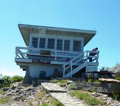 Point Lookout began about 1912 with a tree crow's nest platform. Then in the 1930's an L-4 tower was built on the top of this rocky knob. This lookout tower was replaced with the current structure in 1956, but didn't change much from the previous one. The US Forest Service maintains and operates this lookout tower.
The view to the north and east from this location is incredible! Mt. Thielsen looms up in the sky and is the first mountain you recognize. On a clear day look around and you can see more mountains beyond Thielsen! Don't forget to look down too! You are over the Needle Rocks which loom so high from Rd 66.
We had a very nice visit with the lookout attendant. She has been at this lookout for 18 years and is very knowledgeable on the area. Just ask permission and she will be happy to give you a tour around the catwalk, and sign her guest book too! PLEASE DO NOT DISTURB HER BEFORE 10:00AM. These people work until after dark watching for smokes, so they like to sleep in!
The cache is a regular size container and is hidden where the lookout lady can clearly watch you search. If you choose to skip the tour of the lookout you can find it without disturbing her. It has the usual log book and trade items.
Getting there - On Hwy 62 at Prospect, take Forest Service Rd 64 for about 3 miles to the 200 road on the left. Stay on the 200 road all the way. (There are side roads off this road but road markers are present). You will come to a major intersection with Rd 290 which goes to White Point Lookout. Stay to the right to get to Hall's Point. There is a good parking and turnaround area at the locked gate and then you have to hike about 1/4 mile down and up a very steep road to the final destination. (But it is worth the hike!!) Most any high clearance vehicle can drive in here. At an elevation of just over 5000' this will NOT be accessible when it snows!
![]()