Looping the Bluff ! Traditional Geocache
-
Difficulty:
-

-
Terrain:
-

Size:  (regular)
Please note Use of geocaching.com services is subject to the terms and conditions
in our disclaimer.
The Bluff River Gorge is situated about an hour northeast of Hobart in the Swansea State Forest. This is a scenic walk of approximately 12 km around a loop track of the gorge. There are a couple of steeper slopes to be negotiated. The cache is approximately halfway around the loop.
This is one of a series of 3 caches placed to highlight different features of the gorge.
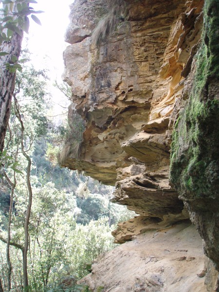
The narrow Bluff River Gorge is up to 80m deep and is notable for its steep sides and spectacular sandstone cliffs and caves. The winding river twists through the gorge forming many pools and runs.
The track is a little overgrown and indistinct in some places but should be relatively easy to follow for those with bushwalking experience as it is quite well marked with tape.
To get to the start of the walk you must first travel to Buckland, then turn off to the north onto the Buckland Road and travel for approximately 11km. There is a clear boundary between private property (open paddocks) and the state forest, which crosses the road in an obvious straight line, where the parking coordinates are located.
The track starts parallel with the fence line, and after a short distance you reach a small clearing where there is a fork in the track and a big tree with an arrow on it. The easier but slightly longer route is to take the right fork (in the direction of the arrow). This eventually leads to another small clearing where the gorge walk proper starts (see photo). You will need to leave the fire trail at this point and the trail to the gorge is narrow but defined. Head downhill to another not so obvious fork where the track branches off either around a tree (to GC2ZFA) or downhill, which is the way you need to go. Watch out for stinging nettles at this spot. After approximately 30 m there is another fork; you need to go left down the slope, NOT straight ahead across the creek. The track you take leads down to the base of the gorge and the Bluff River. At normal or low levels you can cross easily over the river (only narrow at this point) using the stepping stones. Look carefully for the ribbon that marks the track on the other side - it goes right a little then winds uphill to the left. From here on it is a little easier to follow, but waypoints along the track are included below. A more complete track description can be found here.
As the area is isolated and the walk is not described in any guidebooks, you can also download a gpx file of the route, if required. Note that Mapsource or Roadtrip will show the track but not GSAK.
Additional Hints
(Decrypt)
Haqre ebpx va sebag bs pnir, oruvaq zbffl ebpx
Frr fcbvyre cvpgherf