Tschafonwasser EarthCache
-
Difficulty:
-

-
Terrain:
-

Size:  (not chosen)
Please note Use of geocaching.com services is subject to the terms and conditions
in our disclaimer.
 Dolomitklippen des Tschafon mit der Völsegg-Spitze (links)
Ein Earth-Cache zum Thema Wasserversorgung im Schlerngebiet.
Seit 2009 gehören 9 ausgewählte Berggruppen der Dolomiten zum Weltnaturerbe "Dolomiten" und sind als eine der schönsten Berglandschaften in ihrer Einzigartigkeit und ihrer geologischen/geomorphologischen Bedeutung weltweit anerkannt.
Rund 250 Millionen Jahre alt sind die Dolomiten, die zu einem großen Teil aus Sediment- und Kalkstein bestehen. Kaum vorstellbar ist heute, dass die mächtigen Felsen und Gipfel einst ein riesiges Korallenriff waren, das sich im Urmeer Tethys gebildet hatte.
Ein typisches Kennzeichen der Dolomitberge ist der plötzliche Wechsel zwischen schroffen Felsen und sanften, grünen Almflächen. Der Grund dafür liegt in verschieden harten Gesteinsschichten, im unterschiedlichen Schichtaufbau sowie die abwechselnde Hebung und Senkung ganzer Gesteinsblöcke aufgrund von Überflutungen. |
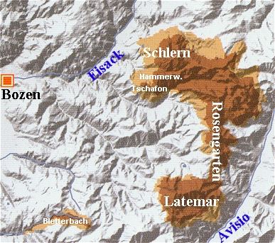
Auf der Suche nach dem "Tschafonwasser"-Earthcache wanderst du durch einen Teil des Dolomiten-Weltnatuerbes: der Schlern-Rosengarten- und Latemargruppe und zwar südlich des Schlern. Dabei hast du vom Gipfel des Tschafonbergzuges, der Völsegg-Spitze, einen tollen Rundblick über diesen Teil. Bei deinem Weg um die Völsegg-Spitze sind die den Gipfel bildenden Dolomitgesteine auch an der Hammerwand besonders gut zu sehen.
Der Tschafon zusammen mit der benachbarten Hammerwand ist vom Schlernmassiv durch ein Tal, geschaffen vom Schlernbach, getrennt. Vor allem auf der südlichen und südwestlichen Seite des Tschafon entspringen viele Quellbäche, die zum Breibach hin entwässern. |
 |
Der Wasserreichtum wird zur Trinkwasserversorgung der Region genutzt. Dazu sind unterhalb der Völsegg-Spitze verschiedene technische Anlagen gebaut worden.
Um den "Tschafonwasser"-Earthcache zu loggen, schicke die Antworten auf folgende 2 Fragen an die
e-Mailadresse des Owners.
1. In welchem Jahr ging die Trinkwasseranlage am Ort des Caches in Betrieb?
2. In welcher Höhe befindet sich die Anlage?
Bei richtigen Antworten erhältst du schnell eine Logfreigabe. |
(ita) (Molte grazie alla signora Weissenegger per la traduzione.)
Acqua della cima Tschafon
Una Earth-Cache sull'approvvigionamento idrico in altipiano dello Sciliar.
Dal 2009 comprende nove gruppi dolomitici selezionati come Patrimonio Mondiale Naturale "Dolomiti" e sono considerati uno dei paesaggi montani più belli della loro unicità e la loro importanza geologico / geomorfologico riconosciuto a livello mondiale.
Circa da 250 milioni di anni esistono le Dolomiti, che sono in larga misura di sedimenti e di calcare. Difficile da immaginare oggi che le scogliere massiccia e cime una volta erano una barriera corallina enorme, che era stata formata nel mare della Tetide. Una caratteristica tipica delle montagne dolomitiche, l'improvviso cambiamento tra scogliere e colline verdi di pascoli. Il motivo risiede in diversi strati di roccia dura, nella struttura dei livelli differenti e l'ascesa e la caduta di alternanza interi blocchi di roccia risultante dalle inondazioni.
Alla ricerca del "Acqua della cima Tschafon" Earthcache attraversi una parte del meraviglioso mondo naturale delle Dolomiti: il gruppo Latemar e il gruppo Rosengarten che in effetti si trova a sud dello Sciliar.
Qui dall'alto trovi la cima Tschafon, la punta Völsegg, e da qui hai una splendida vista panoramica su questa parte.
Nel percorso per la punta Völsegg le forme delle rocce dolomitiche sono ben visibili anche sulla parte della parete martello (Hammerwand).
La cima Tschafon insieme a parete martello vengono separati, dal massivo monte Sciliar, da una valle creata dal fiume Sciliar.
Soprattutto sul lato sud e sud-occidentale della cima Tschafon sporgono tanti ruscelli che scorrono in un enorme fiume. L'abbondanza di acqua è utilizzata per la fornitura di acqua potabile nella regione. Per questo motivo sotto la punta Völsegg sono stati costruiti diversi impianti tecnici.
Per accedere alla Earthcache "Acqua della cima Tschafon" invia le risposte alle seguenti due domande al indirizzo e-mail del proprietario.
1) In che anno è entrato in funzione l’impianto acqua potabile della zona del proprietario?
2) in che altezza si trova l’impianto?
(eng) (Thank you, Bernd, for translation.)
An earth cache with the subject "water supply in the Schlern district".
Since 2009 nine selected mountain ranges in the Dolomite Alps belong to the "Dolomites" World Heritage - natural site. They are known as one of the most scenic mountain landscapes. Because of their uniqueness and their geological/geomorphologic importance they are recognized worldwide.
The Dolomites are approximately 250 million years old. They consist in large parts of sedimentary rock and limestone. Today it is hardly imaginable that these mighty rocks and peaks were once an enormous corral reef which had formed in the primordial Tethys Sea.
A typical mark of the Dolomite Mountains is the sudden change between jagged rocks and gentle, green mountain meadows. This is because of varying rock layers, in different buildup as well as in alternating rise and decline of whole rocks resulting from flooding.
To find the "Tschafon Water" Earthcache, hike through a part of the Dolomite World Heritage natural site: the "Schlern Rose Garden" and the "Latemar Group" south of the Schlern. You will have from the peak of Tschafon Mountain Ridge, the "Völgsegg-Peak", a fantastic round-view across this part. On your way around the "Völsegg Peak" you will particularly well see a the peak-forming Dolomite rocks and the Hammerwand .
The Tschafon, together with the bordering Hammerwand, is separated from the Schlernmassiv by a valley, created by the Schlernbrook. Especially at the southern and south-west side of the Tschafon many springs flow towards the Breibach.
The wealth of water is being used for the supply of drinking water to the local region. For this purpose various technical installations were built below the Völsegg peak.
To log the "Tschafonwasser (Tschafon-Water) Earth-cache, send replies for the following 2 questions to the
E-mail address of the owner.
1. During which year did the drink water facility start at the place of the cache?
2. At which elevation is the water facility located?
Upon receipt of correct replies you will quickly receive a release of the log.
Additional Hints
(No hints available.)