Svenska
Postglacial landhöjning
I slutet av senaste istiden var delar av norra Europa och Nordamerika täckta av ett istäcke. Det var som tjockast 4 km, tjockleken avtog utåt kanterna.
Den tjockaste delen av inlandsisen utövar ett förhöjt tryck på jordskorpan, och det sammanlagda trycket av jordskorpa och inlandsis utövar ett förhöjt tryck på magman. Den rörelse som där av uppkommer i magman är inte riktad nedåt, utan åt sidorna.
Långsamt, långsamt förflyttas magman med hög densitet utåt periferin, och ersätts av ny magma underifrån, men inte snabbt nog för att fylla upp den ”hålighet” som bildats.
Inlandsisen och jordskorpan tillsammans verkar utåt från centrum, detta är vad som leder till ”landsänkning”. När inlandsisen försvinner, vänds kraftverkan. Inte uppåt som man skulle kunna tro, utan inåt. Detta leder då till ”landhöjning”.
I Skandinavien upplever vi en land höjning, andra delar av världen upplever en landsänkning.
Lite enkelt kan man likna denna process med att klämma på en ”stressboll”.
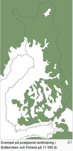
Inledningsvis var landhöjningen i storleksordningen 75mm/år. Denna fas pågick i ca 2000 år då isen tunnades ut och drog sig undan. När isen försvunnit , minskade landhöjningen till circa 25mm/år, och avtog sedan exponentillt. Landhöjningen beräknas pågå i circa 10 000 år till. Där landhöjningen är som störst kan 50-100m återstå.
I Sverige är landhöjningen som alldra störst i Norrland och i synerhet i Ångermanland (Höga kusten), där den vuxit med 5 meter de senaste 500 åren. Nuvarande maximum ligger vid Furugrund i Skellefteå kommun.
Den pågående klimatförändringen kan resultera i att landhöjningen minskar pga att medelhavsvattenytan höjs. I en prognos från ett FN-organ 2007 har prognosticerats en höjning av medelhavsvattenytan på 0,15-0,5 m under de närmsta 100 åren.
I Sverige trodde man på sjuttonhundratalet att det rörde sig om en vattuminskning. På initiativ av Anders Celsius inhöggs ett antal märken i bergväggar runt om i landet. Med hjälp av dessa kunde man redan 1765 konstatera att det inte var en vattenminskning utan en olikformig landhöjning. Bjuröklubb är en av platserna där man huggit in landhöjnings märken. Hela Bjuröklubb består av slipade berghällar täckta av vågspolad sten, bitvis av stora fält med klappersten.
Besvara följande frågor och maila svaren till mig:
- Vid cachekoordinaterna finns det två årtal inhuggna i berget, vilka?
- Hur stor har landhöjningen varit i snitt per år mellan dom två årtalen? (Mät från överkant på båda årtalen)
- Hur många år sedan steg den högsta klippan på Bjuruklubb ur havet?
- Hur stor är landhöjningen på denna platsen?
- Anta att landhöjning fortsätter i samma takt, hur många år kommer det då att ta innan Bottenviken är en insjö?
Bonus: Ta gärna en bild på dig och din GPS på platsen och bifoga i loggen.
Logga och skicka svaren, om svaren är fel så raderas loggen.
Inga svar i loggen tack.
Lycka till!
English
Post-glacial rebound
By the end of the last Ice Age, parts of northern Europe and North America were covered by an ice cover. It was as thick as 4 km in some places, the thickness decreased towards the edges.
The thickest part of the ice sheet exerted an increased pressure on the earth’s crust, and the total pressure of the crust combined with the ice exerted an increased pressure on the magma. The movement that occurred in the magma was is directed not downwards, but sideways.
Slowly, slowly high density magma was moved outwards and replaced by new magma below, but not fast enough to fill the cavities created.
The inland ice together with the earth’s crust pushed outwards from the center, this is what leads to "land subsidence". When the ice disappeared, the force in action reversed. However, the force was thus directed inwards, not upwards as one might think.
While Scandinavia is experiencing a rise of land, a post-glacial rebound, in other parts of the world land subsidence can be seen.
Initially, the rebound was as much as 75 millimeters per year. This phase lasted about 2000 years while the ice was thinned and retreated. When the ice was fully retreated, the rebound was reduced to about 25 millimeters per year, and then declined exponentially. The rebound is estimated to continue for another 10 000 years. In places where the rebound is especially large, the land might rise with another 50-100 meters.
In Sweden, the rebound is the greatest in the north. The current maximum is located in Furugrund, in Skellefteå. However, the climate changes might result in a decrease, due to a rise in sea water level.
During the eighteenth century in Sweden, people thought the rise in land was due to a decreasing water level. A man called Anders Celsius therefore initiated the process of carving marks in rocks and cliffs all around the country. With the help of these they did, already in the year 1765, realize that the sea level was not changing but that the land was rising (however at different rates). Bjuröklubb is one of the places where they carved markings into the rocks.
To log the cache answer the following questions and send the answers to me via e-mail:
- At the coordinates there are two separate dates carved into the rock, which?
- What is the average yearly rebound in the years between the two dates? (Measure from the top on both of the dates)
- What year did the highest rock in Bjuruklubb rise from the sea?
- How large is the post-glacial rebound on this site today?
- Assuming the rate of the rebound remains at today’s level, how many years will it take for the Gulf of Bothnia (Bottenviken) to turn into a lake?
Bonus: Take a picture of you and your GPS at the site and attach to the log..
Log and send the answers, if answers are wrong the log is deleted.
No answers in the log, thanks.
Good luck!