"A Bekkesrsdal Marathon" is a wonderful short story by Herman Charles Bosman. To understand the name of the cache a bit better, please read the story which can be found by clicking here.
The Pulpit is a inspirational spot, with majesty all around. It can be quite mesmerizing, and it is easy to imagine Dominee Welthagen saying "Sing Psalm 119", slumping forward and going into a trance!
 Dominee Welthagen, reading the sermon, just before slumping forward.
The way up to the cache involves climbing up steep slopes for most of the way. The climb is a kind of a marathon in it's own right. You will probably need to have a few swigs at some of your own refreshments on the way up. (I hope they don't cause any kind of swirls at all.)
If one walks form the forestry station via this route to Maclear's beacon there is about 1000m change in altitude. The highest ascent on Table Mountain. If other walks on the mountain are like psalms a few verses long, this is PSALM 119!
I highly recommend printing this description, with the photos, and taking it along for reference. Sometimes paperless caching just doesn't cut it.
The route to the cache is tough, and should only be done if you are accustomed to scrambles and long hikes. The climb took us about 4½ hours to get to the top. Just about the whole route will take you up steep gradients. There are various points along the way that require climbing up exposed rock faces. The longest of these climbs is at the top of the route, ABOVE the cache. You need a good level of fitness to ensure you have strength in reserve, to tackle the climb near the top of the ascent. DO NOT ATTEMPT THE CACHE FROM THE TOP OF THE MOUNTAIN! Climbing down these rock faces is much more dangerous than climbing up. Please consider the weather, much of the ascent is in sunlight in the morning.
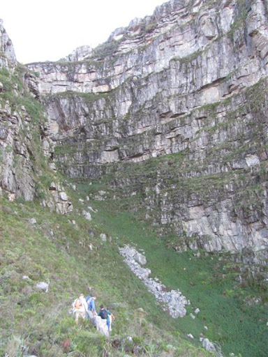
Below are two photos of the route:


Route Description:
Leave the contour path to enter Hidding Ravine at S33 58.246 E18 26.001 (1 in the photos). Follow the occasional cairns up the ravine, but don't stress if you don't see them often. Keep going up until the ravine narrows and becomes very green, with the path leading through ferns. At at this point, at about S33 58.184 E18 25.841 (GPS reception is very poor) look for a pair of cairns (2). They can be seen on the right of the picture below:

These mark the place to leave the ravine which is slightly up and to the right from the cairns. A slippery little scramble will lead you onto a traverse between rock bands. This is clearly marked with cairns. After a short traverse you will find a cairn at S33 58.168 E18 25.940, (shown as (3)) marking the place where you have to stop traversing and need to start the scrabble up a narrow gully on the left side of the buttress. Do not traverse right around the buttress. After a short bit if climbing, there is a short length of chain on one of the scrambles. The gully is very steep, with loose rock all the way up. Please exercise caution trying to ensure that if rocks are dislodged, climbers below will not be hit. At the top of the gully at S33 58.167 E18 25.865, (4) a horizontal promontory makes a great resting spot, with nice views into Hidding gorge. After a bit of a rest, traverse North, across the top of the gully, to a ledge. Traverse along the ledge on the very faint path. Once you reach the front of the butress at S33 58.138 E18 25.908, (5) look for cairns leading you up the spine of a ridge. Boulder hop your way up the spine. Often you will only see the cairns as you get to them, or pass them. Just proceed up the spine, heading for the base of the pulpit at S33 58.104 E18 25.815 (6). From there, traverse further to the right (north) into Ascension Ravine. Find the path near the stream in the middle of the ravine. Now it becomes quite a long climb up up the ravine until one can walk across the top of the pulpit to the cache. The path makes a small fork at about S33 58.075 E18 25.693 (7). Forking left will take you to the pulpit, a spectacular view (180º of which are the steep cliffs behind you) and the cache!!!
After finding the cache, gather your strength for the last climb up the ravine.
Follow the path to the top of the ravine and you will be lead onto another ledge traverse (8). After a short distance you will find an obvious cairn at the base of a rock face at about S33 58.102 E18 25.635 (9).It marks the beginning of a scramble up the rock face (this scramble can be skipped by traversing further round the buttress). It is quite a challenging scramble and can be tough after such a long hike. It is quite a long pitch. Take it slowly, it is the last real hurdle on the way to the top. After reaching the top of the scramble, simply follow your nose to the spine of the ridge, follow it, and within a short time you will be on top of the mountain. A mountain guide book stated that on can skip the scramble by traversing further round the buttress and finding your way up from there, but we did not follow that route.
The way down is pretty much your choice! We opted for Skeleton Gorge.